Jonathan Erdman
The Northeast urban corridor from Boston to Washington, D.C., is in a season-long snow drought, with some of the nation's most stunning snowfall deficits.
Let's dive into why this season has been so bizarre for the nation's most densely populated region.
Not Even An Inch All Season, Yet
Specifically, areas near Interstate 95 from southern Connecticut into New York City, New Jersey, southeast Pennsylvania, Maryland and Delaware haven't managed to scrape up even an inch of snow since fall.
Just a few hours after February began, New York City's Central Park finally picked up its first measurable snow of the season, the longest they've had to wait in records dating to 1869.
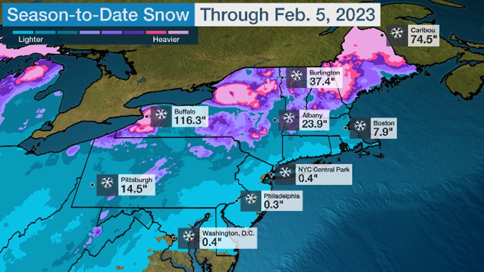 Season-to-date snowfall (in inches) through Feb. 5, 2023 in the Northeast.
The Deficits Are Throughout The Northeast
While the map above shows higher totals in the interior Northeast, most of those locations are also in snow deficits.
Boston's 7.9-inch total is 19 inches below the average through Feb. 5.
Snowfall totals in Albany, New York, and Burlington, Vermont, look more impressive, but they're 10 to 13 inches less snowy for the season than usual.
The only areas in the Northeast with snow surpluses for the season are parts of northern New England, the Adirondacks and the lakes Erie and Ontario snowbelts, including Buffalo's almost 52-inch snow surplus.
One Storm Track Has Been Dominant
A persistent storm track has been most favorable for snow from the West into the Northern Plains and northern Great Lakes.
Low-pressure systems have most often plowed into the West Coast, intensified in the High Plains of the Rockies, then tracked into the northern Great Lakes or eastern Canada. That's a pattern typical of late fall or spring, steering winter storms through the Dakotas or areas nearby.
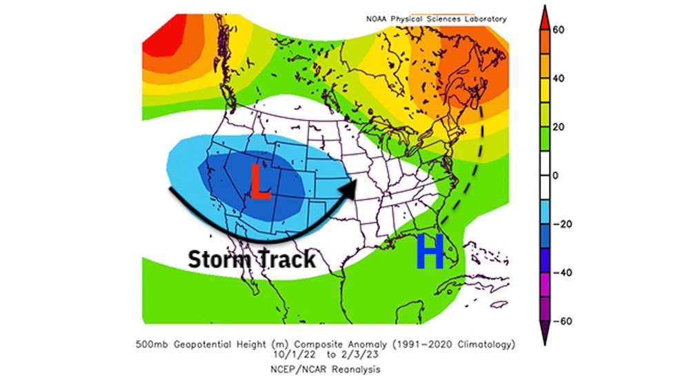 Anomaly in the upper-level weather pattern over the U.S. and Canada from Oct. 1, 2022, through Feb. 3, 2023. Areas of persistent lower pressure are highlighted by the "L" and the blue contours over the West and Plains. Areas of higher pressure are highlighted by the "H" and the green, yellow and orange contours along the East Coast from Florida to Atlantic Canada.
That pattern has also pumped warmer air northward along the East Coast.
January was the warmest on record in Allentown, Pennsylvania, New York City, and Worcester, Massachusetts, according to the Southeast Regional Climate Center. The three-month period ending Feb. 5 was among the warmest such early November through early February periods on record in the Northeast and New England.
But What About Coastal Lows?
When low pressure actually formed closer to the Northeast, it brought snow to the interior Northeast but pulled warm air into the I-95 Northeast Urban Corridor, with rain the result.
Three January storms, named winter storms Iggy, Jimenez and Kassandra by The Weather Channel, each dumped significant snow in the interior Northeast, but predominantly only rain from New York City southward.
Why Haven't Cold Snaps Produced I-95 Snow?
When cold air swept into the Northeast, it whipped across the Great Lakes and manufactured two rounds of prolific lake-effect snow in Buffalo and Watertown, New York, in late November and December.
And last Friday and Saturday's bitter arctic front set cold records in northern New England, but came through dry along the Interstate 95 urban corridor.
Any Snow Ahead?
For the I-95 urban corridor, the short answer is no.
Yet again, generally warmer-than-average air is expected to dominate the eastern U.S. until perhaps Presidents' Day weekend.
That means any weather systems affecting the Northeast are most likely to produce some interior snow, but, once again, mainly rain from coastal southern New England southward to New York City, Philadelphia, Baltimore and Washington, D.C.
 NOAA 8-14 Day Temperature Outlook
Is The Snow Season Over Already?
We can't completely close the book on the 2022-23 snow season, despite its pathetic showing so far. If this pattern suddenly changes in March or even April, significant East Coast storms can develop.
On average, New York City's Central Park picks up 5.4 inches of snow in March and April combined; That's the same amount the city averages in November and December combined.
Central Park has had 10-inch-plus March snowfalls in 2015, 2018 and 2019. That includes a stretch of four nor'easters in three weeks in March 2018.
So if you're looking to skate through a winter with almost no snow, enjoy this warmer spell while you can.
The Weather Company’s primary journalistic mission is to report on breaking weather news, the environment and the importance of science to our lives. This story does not necessarily represent the position of our parent company, IBM.
The Weather Company’s primary journalistic mission is to report on breaking weather news, the environment and the importance of science to our lives. This story does not necessarily represent the position of our parent company, IBM.


No comments:
Post a Comment