Linda Lam
Severe thunderstorms with damaging winds are expected to develop in parts of the Central and Southern Plains Sunday into early Monday.
Here's a closer look at what to expect with this upcoming severe threat.
Severe Outlook
Area Of Concern: Areas from northern Texas into Kansas and western Missouri have the highest chance of severe thunderstorms, especially in western Oklahoma. The chance for isolated severe storms extends into southern Nebraska, central Illinois and northwest Arkansas.
Threats: Damaging wind is the main concern but some large hail and few strong tornadoes are also possible.
Now is a good time to review or form a severe weather plan. Severe weather can occur year-round but usually ramps up in March, followed by the peak months of April, May and June.

The severe threat will continue on Monday for parts of the Ohio Valley as the system moves east.
Area Of Concern: Areas from central Illinois to southeastern Ohio and northern Kentucky have the highest chance of severe weather. This includes Cincinnati, Indianapolis and Springfield, Illinois.
The main threat will once again be damaging winds, but an isolated tornado or two can't be ruled out.

Timing
Sunday: Thunderstorm development may not occur until late Sunday afternoon or the evening hours and is most likely in areas shown in red on the map below.
A few supercell thunderstorms may form in the afternoon and early evening before a line of thunderstorms organizes.

Sunday Night: A line of severe thunderstorms is expected to push eastward from the evening possibly into the overnight.

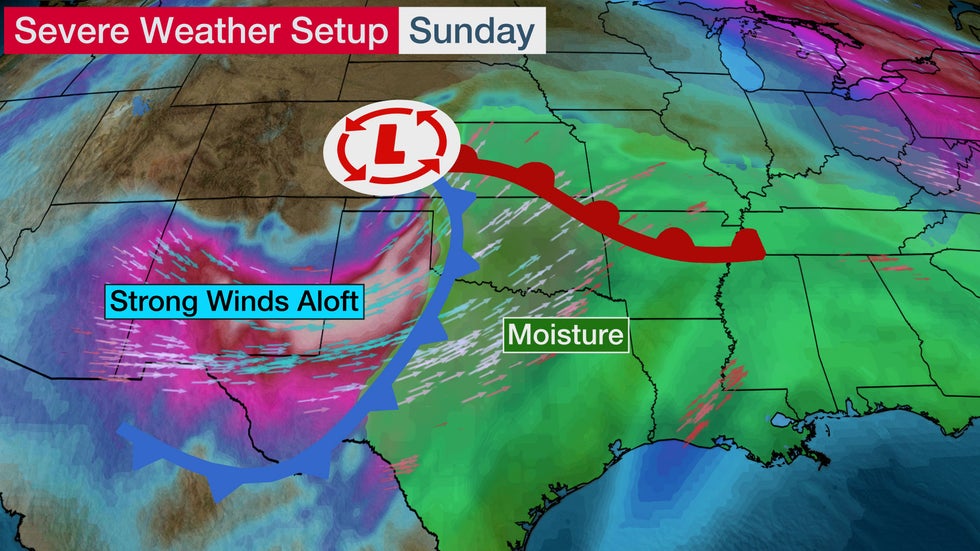
The Setup
An area of low pressure will emerge in the Plains on Sunday and strengthen as it tracks northeastward. This is the same system that is now pummeling California. More information about that part of this system can be found here.
Moisture will increase ahead of this system and temperatures will warm into the 60s and 70s, which will help to increase instability.
Strong winds just above the surface will contrast with lighter winds at the ground and will be favorable for supercell development.
The ingredients currently look to be favorable for at least some severe thunderstorms to form beginning late Sunday afternoon.
(MAPS: Weather And Highs Next 7 Days)
Unusual Threat For February?
Recent severe weather has primarily targeted the Deep South, but Sunday's threat is a bit farther west in portions of the Plains.
Severe thunderstorms are not as common in the central and Southern Plains in February, but can happen.
Usually, the Deep South is at an elevated risk in February because of its proximity to the Gulf of Mexico, where warm, moist air can surge northward, adding to the instability in the atmosphere.
(Deeper Look: February's Typical Tornado Threat)
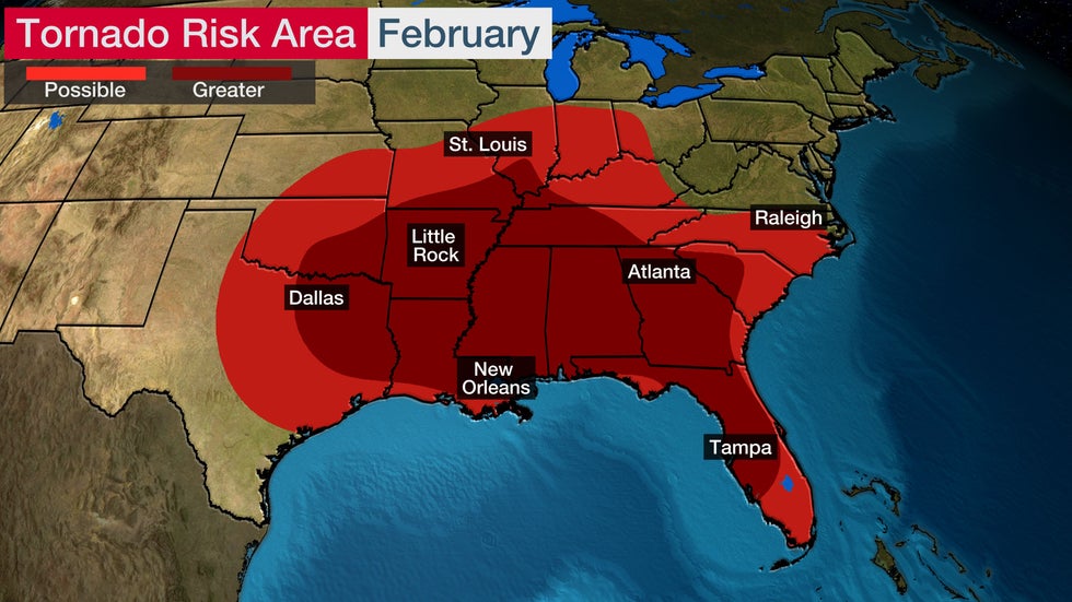 In the lighter red areas, there is a 0.1% probability of a tornado within 25 miles of a point by late February. The darker red shading is for locations that have a 0.2% probability of a tornado within 25 miles of a point by late February. Based on 1982-2011 averages.
The Weather Company’s primary journalistic mission is to report on breaking weather news, the environment and the importance of science to our lives. This story does not necessarily represent the position of our parent company, IBM.
The Weather Company’s primary journalistic mission is to report on breaking weather news, the environment and the importance of science to our lives. This story does not necessarily represent the position of our parent company, IBM.


No comments:
Post a Comment