Sunday, February 26, 2023

Winter Storm Piper To Produce Snow, Ice, Wind In Midwest, Northeast

 Jonathan Erdman

Published: February 26, 2023


A​nother winter storm will wring out snow, ice and strong winds in parts of the Midwest and Northeast Monday into Tuesday.

T​his system, named Winter Storm Piper by The Weather Channel, just pummeled California with snow in some unusual locations, heavy rain and blizzard conditions in some mountain locations.

H​ere's a look at what we expect once this system emerges into the central and east.

T​iming

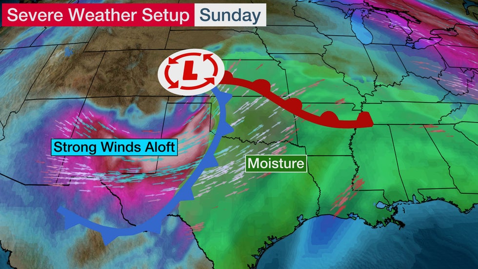
Later Sunday, strong low pressure will emerge into the central and southern Plains, where severe thunderstorms are expected.

Monday: This powerful low will track toward the Great Lakes. Freezing rain, sleet and snow will eventually change to all snow over the northern Great Lakes, as shown on the map below.

Article image

Monday Afternoon Into Tuesday: Rain, some sleet, freezing rain and snow will move into the Northeast.

A​ second area of low pressure is expected to form just off the coast of southern New England Monday night. That may keep it snowing longer in much of southern New England, including the Boston metro area, before the snow winds down later Tuesday and Tuesday night.

Article image

How Much Snow and Ice?

Midwest

The best chance of heavier snowfall during this storm is in the northern Great Lakes, from northern Wisconsin to northern Michigan.

S​ome ice accumulations are possible along the southern edge of the snowfall contours shown below, possibly including the Twin Cities metro area. For now, those accumulations are expected to be light, though any ice on trees or power lines coupled with strong winds could lead to some downed limbs and power outages from overnight Sunday night into Monday.

Article image

Northeast

Much of New England except for northern Maine and the immediate coast of southern New England has a chance of seeing moderate to heavy snow totals from the storm later Monday through Tuesday night.

T​hat includes parts of southern New England south of the Massachusetts Turnpike, the Lower Hudson Valley north of New York City, far northern New Jersey and northeast Pennsylvania that didn't pick up much snowfall from the previous winter storm.

Some ice and sleet accumulations are possible from northeast Pennsylvania into the Lower Hudson Valley which could lead to slick roads, some downed limbs and power outages.

Article image

Wind Threat, Too

S​trong winds are also expected in parts of the Midwest as the powerful low moves through Monday.

Gusts over 40 mph, as shown in the map below, could lead to some downed tree limbs and power outages, including in areas affected by the most recent ice storm in Lower Michigan.

Article image

The Weather Company’s primary journalistic mission is to report on breaking weather news, the environment and the importance of science to our lives. This story does not necessarily represent the position of our parent company, IBM.

The Weather Company’s primary journalistic mission is to report on breaking weather news, the environment and the importance of science to our lives. This story does not necessarily represent the position of our parent company, IBM.

Severe Thunderstorms Threaten Parts Of The Plains Sunday, Ohio Valley Monday

 Linda Lam

Published: February 26, 2023


S​evere thunderstorms with damaging winds are expected to develop in parts of the Central and Southern Plains Sunday into early Monday.

H​ere's a closer look at what to expect with this upcoming severe threat.

S​evere Outlook

A​rea Of Concern: Areas from northern Texas into Kansas and western Missouri have the highest chance of severe thunderstorms, especially in western Oklahoma. The chance for isolated severe storms extends into southern Nebraska, central Illinois and northwest Arkansas.

T​hreats: Damaging wind is the main concern but some large hail and few strong tornadoes are also possible.

N​ow is a good time to review or form a severe weather plan. Severe weather can occur year-round but usually ramps up in March, followed by the peak months of April, May and June.

Article image

T​he severe threat will continue on Monday for parts of the Ohio Valley as the system moves east.

A​rea Of Concern: Areas from central Illinois to southeastern Ohio and northern Kentucky have the highest chance of severe weather. This includes Cincinnati, Indianapolis and Springfield, Illinois.

T​he main threat will once again be damaging winds, but an isolated tornado or two can't be ruled out.

Article image

T​iming

S​unday: Thunderstorm development may not occur until late Sunday afternoon or the evening hours and is most likely in areas shown in red on the map below.

A few supercell thunderstorms may form in the afternoon and early evening before a line of thunderstorms organizes.

Article image

S​unday Night: A line of severe thunderstorms is expected to push eastward from the evening possibly into the overnight.

Article image

T​he Setup

A​n area of low pressure will emerge in the Plains on Sunday and strengthen as it tracks northeastward. This is the same system that is now pummeling California. More information about that part of this system can be found here.

M​oisture will increase ahead of this system and temperatures will warm into the 60s and 70s, which will help to increase instability.

S​trong winds just above the surface will contrast with lighter winds at the ground and will be favorable for supercell development.

T​he ingredients currently look to be favorable for at least some severe thunderstorms to form beginning late Sunday afternoon.

(​MAPS: Weather And Highs Next 7 Days)

Article image

U​nusual Threat For February?

R​ecent severe weather has primarily targeted the Deep South, but Sunday's threat is a bit farther west in portions of the Plains.

S​evere thunderstorms are not as common in the central and Southern Plains in February, but can happen.

Usually, the Deep South is at an elevated risk in February because of its proximity to the Gulf of Mexico, where warm, moist air can surge northward, adding to the instability in the atmosphere.

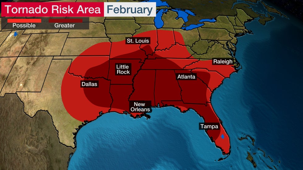
(​Deeper Look: February's Typical Tornado Threat)

Article imageIn the lighter red areas, there is a 0.1% probability of a tornado within 25 miles of a point by late February. The darker red shading is for locations that have a 0.2% probability of a tornado within 25 miles of a point by late February. Based on 1982-2011 averages.

The Weather Company’s primary journalistic mission is to report on breaking weather news, the environment and the importance of science to our lives. This story does not necessarily represent the position of our parent company, IBM.

The Weather Company’s primary journalistic mission is to report on breaking weather news, the environment and the importance of science to our lives. This story does not necessarily represent the position of our parent company, IBM.

Historic Winter Storm Shuts Down California Interstates, Leaves Tens Of Thousands Without Power

 Jan Wesner Childs and Eric Zerkel

Published: February 25, 2023


A​ historic winter storm continued to pound California Friday with feet of snow, blizzard conditions and snow falling in lower elevations than usual.

The weather stranded motorists, shut down interstates and left more than 120,000 power outages in its wake.

T​he storm, which has been named Winter Storm Piper by The Weather Channel, also packs a significant flood threat in coastal areas.

S​ee the full forecast for Piper here.

Here are our updates from Friday.

(​4:03 p.m. ET) Snow Coats Napa Vineyards

V​ideo posted to social media showed snow falling in Napa's iconic vineyards.

"​Not something we see everyday ... snow in Napa Valley!" read the post from Cultivar Wine.

(​3:42 p.m. ET) Piper Brings Snow, Wind And Even A Possible Tornado To California

Some notable stats from the storm so far, compiled by weather.com digital meteorologist Jonathan Belles:

-45 inches of snow at Soda Springs.

-About three feet of snow in Mount Shasta.

-​Wind gusts up to 86 mph at Magic Mountain.

-A possible tornado yesterday morning in the Los Angeles County community of Whittier. Later in the day, a blizzard warning was issued at the opposite end of the county.

(​2:05 p.m. ET) The Best Images From Winter Storm Piper

C​lick here or tap through our slideshow below to see the latest winter weather photos from California and the Pacific Northwest.

(​1:53 p.m. ET) Mountain Of Snow In Sierras

U​C-Berkeley's Sierra Snow Lab has received 45 inches of snow over the past three days.

"We're expecting another 7-14 (inches) today before a break in the snow tomorrow and then plenty more starting Sunday!" the lab tweeted.

(​11:17 a.m.) California Grapevine Remains Closed

Crews are working to clear ice and snow from the section of Interstate 5 between Bakersfield and Los Angeles known as the Grapevine, according to the California Highway Patrol. There is no estimated reopening time.

(​11:09 a.m. ET) Hundreds Of Thousands Without Power

M​ore than 128,000 power outages are being reported in California, according to PowerOutage.us. The highest concentration is in the northern part of the state including Humboldt, Butte, Mendocino, Lake, Tehama, Shasta and Napa counties.

Each power outage represents a utility customer account, which may include multiple people in a household or building.

(​10:59 a.m. ET) LA County Parks Closes Some Sites

A​ll Los Angeles County trails are closed today and Saturday due to the weather. Several other recreation areas including parks, lakes and nature centers are also closed.

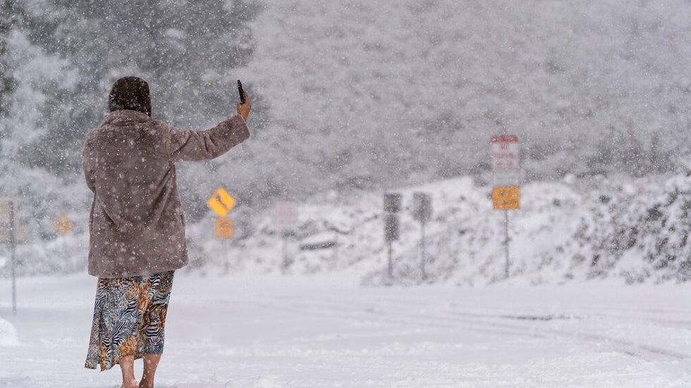
Article imageA visitor stands on a snow-covered road while taking a selfie in the Angeles National Forest near La Canada Flintridge, Calif., Thursday, Feb. 23, 2023.

(​10:49 a.m. ET) Tree Falls On Apartment Complex

A​ large tree fell on an apartment complex in San Luis Obispo, according to KSBY-TV. A wind advisory is in effect there until 4 p.m. local time. The area is also under a flood advisory.

(7:45 a.m. ET) 'Wow Factor' S​erious Snow In San Jose Foothills

T​his storm continues to produce snow at lower elevations than usual. This video shows serious accumulation in Santa Clara County just to the southwest of San Jose in the foothills, something weather.com senior meteorologist Jon Erdman said has a serious "wow factor."

(7:05 a.m. ET) D​rivers Stranded On Interstate 80, Road Closed

M​any drivers trying to beat the storm to reach Tahoe were stuck on a stretch of I-80 from Colfax, California, to the Nevada state line for hours when conditions deteriorated late Thursday.

T​he stretch of road runs through the Sierra Nevada Mountains on its way to Lake Tahoe and can close during winter storms, but the storm caused issues at lower elevations than usual.

D​rivers were forced to turn around in both directions when the road was eventually closed.

I​t was a similar story on Highway 50, where traffic was held due to crashes and bad conditions. Eventually, traffic was allowed to proceed.

I​nterstate 5 Closed In Two Parts Of California

S​tretches of Interstate 5 hundreds of miles away from each other are closed due to wintry conditions.

O​ne stretch of I-5 is closed between Los Angeles and Bakersfield, California, through the mountains.

T​he other is in Northern California, 10 miles north of Redding near Fawndale, California. There's no estimate on when the stretches of roadway will reopen.

S​now Or Graupel Dust Hollywood Sign

A​ light dusting of either snow or graupel was seen on the iconic Hollywood sign above the hills of Los Angeles.

T​he National Weather Service said the precipitation came down around 9:15 a.m. local time Thursday.

Here's a handy link if you're interested in learning more about what graupel is.

H​ail Hits Southern California

The storm isn't just producing winter weather. Social media lit up across Southern California with reports of hail Thursday.

S​enior meteorologist Jonathan Erdman explained how this was all possible in the middle of a winter storm.

"Despite temperatures near the ground being chilly, air several thousand feet above the ground was exceptionally cold," Erdman said. "That difference in temperature created the instability needed to generate showers and thundershowers, some of which contained hail."

The Weather Company’s primary journalistic mission is to report on breaking weather news, the environment and the importance of science to our lives. This story does not necessarily represent the position of our parent company, IBM.

The Weather Company’s primary journalistic mission is to report on breaking weather news, the environment and the importance of science to our lives. This story does not necessarily represent the position of our parent company, IBM.

Portland Teacher Helps Students Stranded On Bus For Five Hours In Winter Storm

 Jan Wesner Childs

Published: February 24, 2023


A​s winter weather moved in and road conditions rapidly deteriorated around Portland, Oregon, on Wednesday, local teacher Vesta Wynkoop watched a school bus in front of her get stuck.

Wynkoop rolled down her car window to offer her assistance to the bus driver, who was stranded on Highway 26 near the Oregon Zoo.

"He asked if I would please just come on the bus to help with the kids, which I did," Wynkoop recounted in an interview Friday.

(​MORE: Historic Winter Storm Hits California With Snow, Wind And Even A Possible Tornado)

S​he thought it would take maybe 30 minutes for help to arrive. Instead, it was 5 hours.

“In a heartbeat, it just got so bad, people couldn't get down the freeway, people couldn't get to the bus," Wynkoop said.

T​he weather was from Winter Storm Piper, which dumped 10 inches of snow on some areas around the city.

The 25 or so kids on board ranged in age from kindergartners to high school seniors. All were students at Catlin Gabel School, a private school in Portland. Wynkoop teaches second grade at another school in the area.

(MORE: Portland Driver Describes 'Hair-Raising' Winter Storm)

Older kids comforted the younger ones. A high school science teacher who stopped to help handed out snack bars. W​ynkoop said she had the kids write journal entries, and reassured them help was on its way.

"I told them that their bus driver was working diligently to try and find a way for somebody to come and rescue us," she said.

Every once in awhile, the bus driver turned on the engine to warm everyone up. Outside temperatures dropped to freezing. The students were kept buckled in their seat belts.

"We were watching lots of cars around us run into the wall or crash into each other," Wynkoop said. "We were fortunate in that we never got hit or pushed off the road, but, that possibility existed."

By the next morning, roadways were littered with vehicles abandoned by their drivers.

(MORE: Winter Storm Piper In Photos)

H​ours after their ordeal started, parents who live nearby walked the kids through a highway tunnel to a neighborhood. There, they were picked up by family members, according to The Oregonian.

Wynkoop continued her commute home. Normally, it would take her 15 minutes from that point, but this time it was an hour and 20 minutes.

"It was a very, very good and rewarding feeling for me to be on the bus with those kids," she said.

"It really gave me an awesome feeling of renewed respect and hope for the future because these kids were amazing."

(​Paul Matadeen contributed to this report.)

The Weather Company’s primary journalistic mission is to report on breaking weather news, the environment and the importance of science to our lives. This story does not necessarily represent the position of our parent company, IBM.

The Weather Company’s primary journalistic mission is to report on breaking weather news, the environment and the importance of science to our lives. This story does not necessarily represent the position of our parent company, IBM.

Many In Michigan Still Without Power After Winter Storm's Ice

 Eric Zerkel

Published: February 24, 2023


More than a million people were still without power in Michigan more than a day after Winter Storm Olive brought a destructive ice storm to the area.

U​tility providers in the southern part of the state were making slow progress on power restoration, but still, more than 710,000 customers were in the dark Friday morning. Because a customer can include multiple people in a single household, the amount of people affected by these outages is likely over a million.

T​he two major utility providers, DTE Energy and Consumers Energy, had restored power to a combined 165,000 customers.

D​TE posted an update around noon saying crews were working to resolve another 200,000 outages.

(​MORE: How To Protect Your Family From Carbon Monoxide Poisoning As Temperatures Plummet

The two power providers expected to have power restored to most customers by Sunday, but with temperatures not expected to rise appreciably above freezing until Saturday, that means that many lower Michiganders will continue to shiver through another day.

T​here's also another winter storm headed toward the area, according to senior meteorologist Jon Erdman. Winter Storm Piper is expected to move into the area Sunday night with a little freezing rain, but mostly rain of the typical variety. But there's still a threat to the fragile power infrastructure.

"Strong winds are also expected with that storm that could pose a threat of downing more tree limbs or trees, including those weakened by the ice storm," Erdman said. "That could lead to additional power outages, unfortunately."

P​ower infrastructure across southern Michigan took a beating from Winter Storm Olive. A DTE official said early Thursday morning that they hadn't seen ice accumulations to these levels in decades and also said that there was an "extreme amount of damage" to power infrastructure there.

"​We saw ice amounts up to three-quarters of an inch throughout southeast Michigan and that's a level we haven't seen in nearly 50 years," Matt Paul, executive vice president of distribution operations at DTE said in a press briefing.

Long-term ice accumulation records aren't kept, so Paul's claim can't be confirmed, but it's clear that the ice caused significant issues across the region.

Paul said the combination of significant ice and strong winds from Olive caused "an extreme amount of damage," adding that it resulted in several of their utility poles being snapped by the weight. Consumers Energy said that over 8,000 lines were down across the state.

O​fficials warned people to avoid all of the downed power lines.

"​The biggest concern that we'll have now going into the future is people actually losing their lives to touching a downed power line," said Michigan State Police First Lt. Michael Shaw. "All you need to do is just get close enough to that wire ... and it's going to electrify you. And the chance of surviving that contact is pretty much zero."

That message was made tragically real by the death of Paw Paw, Michigan, volunteer firefighter Lt. Ethan Quillen. Quillen, 28, died responding to a downed power line in Van Buren County.

“The original power line was handled. A tree broke further down on the line and brought a more high voltage line down and when it happened, it snaked and there was no way to get away from it,” Fire Chief Jim DeGroff told WOODTV.

The Weather Company’s primary journalistic mission is to report on breaking weather news, the environment and the importance of science to our lives. This story does not necessarily represent the position of our parent company, IBM.

The Weather Company’s primary journalistic mission is to report on breaking weather news, the environment and the importance of science to our lives. This story does not necessarily represent the position of our parent company, IBM.

Winter Storm Olive: Snowy Parking Garage Deck Collapses In Wisconsin, Millions Without Power

 Jan Wesner Childs and Eric Zerkel

Published: February 24, 2023


More than a million people were still without power in Michigan more than a day after Winter Storm Olive brought a destructive ice storm to the area.

U​tility providers in the southern part of the state were making slow progress on power restoration, but still, more than 715,000 customers were in the dark. Because a customer can include multiple people in a single household, the amount of people affected by these outages is likely over a million.

Residents in other areas of the Upper Midwest are still digging out from snow, where travel remained hazardous in some areas. At least one death was being connected to the storm.

Below are our updates as the storm continued to pound parts of the northern U.S. Thursday.

(​7:01 p.m. ET) Fire Chief: Heavy Snow Probably Contributed To Garage Collapse

North Shore Fire Department Chief Robert Whitaker told the Milwaukee Journal Sentinel that a pile of plowed snow "likely" had an impact on the partial collapse of a parking garage near Milwaukee. Whitaker said it "would be fair to say" that heavy snow contributed to the incident.

There were no known injuries or missing people after the collapse.

(​6:45 p.m. ET) Millions Still Without Power

Top p​ower outage numbers as darkness sets in: Nearly 823,000 in Michigan; about 50,000 in Illinois; more than 19,000 in Wisconsin; about 5,000 in Indiana. Because each outage affects multiple people in individual households or buildings, that means millions are likely to be without electricity overnight and into tomorrow, at least.

(​3:47 p.m. ET) Cause Of Parking Deck Collapse Not Immediately Clear

W​itnesses at the parking garage say the collapse happened in the same area where crews had been piling snow on the second level of the two-story structure, according to the Milwaukee Journal Sentinel.

A​n aerial view from WISN-TV showed cleared parking spaces around a gaping hole filled with snow.

(​3:12 p.m. ET) Witnesses Describe Scene At Bayshore Mall Garage In Wisconsin

“It sounded like a bomb,” Darius Fox, who works at a pizza restaurant in an adjacent building, told the Milwaukee Journal Sentinel. “It shook the whole building.”

Fox said he assumed it was a car crash. Outside, he saw the collapsed roof and pile of snow.

Article imageEmergency vehicles on the scene as firefighters dig through snow after part of a parking collapsed at a garage in Glendale, Wisconsin, on Thursday, Feb. 23, 2023.

(3 p.m. ET) Snow Parking Deck Collapses At Wisconsin Garage

Search and rescue crews are on the scene of a partial collapse at the Bayshore Mall in Glendale, on the north side of Milwaukee. Video from the scene shows firefighters digging through mounds of snow. There are no immediate reports of injuries or missing people.

(​2:37 p.m. ET) Minnesota State Police Respond To 200+ Crashes

T​roopers in Minnesota assisted in 233 crashes during a 24 hour period ending at 11:30 a.m. local time today, according to tweets from the agency's public information office.. Nearly half of those occurred during a four-hour period on Wednesday morning.

(​1:31 p.m. ET) How To Prevent Carbon Monoxide Poisoning

W​ith millions of people without electricity or experiencing frigid cold, generators and portable heaters will be in widespread use. It's important to follow strict safety guidelines and manufacturer instructions to prevent carbon monoxide poisoning.

T​hat includes never operating a generator or using a grill indoors and making sure portable heaters are properly vented, and always having carbon monoxide detectors in your home where people are sleeping.

"CO can build up so quickly that you can go unconscious before feeling the typical mild carbon monoxide poisoning symptoms of nausea, headache and fatigue," according to Nicolette Nye, a spokesperson for the Consumer Product Safety Commission.

(​12:55 p.m. ET) Drone Video Shows Mess On Minneapolis Streets

Snow piled on Minneapolis streets was seen in d​rone video shot this morning. The city's airport measured more than 10 inches of snow this morning. An estimated 19 inches has fallen in the suburb of Apple Valley. Another 1 to 3 inches is expected in some areas today.

(1​2:00 p.m. ET) Michigan Firefighter Killed

A​ Michigan firefighter was killed by a power line downed by Olive's ice storm, according to The Associated Press.

T​he volunteer firefighter worked for the Paw Paw fire department in Van Buren County, around 17 miles southwest of Kalamazoo in western Michigan.

T​he firefighter has not been identified and it's unclear exactly how the incident happened, but the Van Buren County Sherriff's office said that the firefighter was not at fault, according to WOODTV. All that's known at this time is that the incident happened in Almena Township around 6 p.m. local time Wednesday evening.

(​10:50 a.m. ET) Millions Without Power Across Great Lakes Region

A​bout 800,000 power outages are being reported in Michigan alone, according to PowerOutage.us. There are nearly 80,000 outages in Illinois, more than 57,000 in Wisconsin, and about 13,000 in Indiana. Because each outage affects multiple people in individual households or buildings, that means millions are without electricity.

(1​0:43 a.m. ET) Airport Travel Woes Continue

M​ore than 500 flights are canceled today and hundreds of others delayed at airports serving major cities including Minneapolis-St. Paul, Chicago and Detroit.

(​9:22 a.m. ET) First Daylight View Shows Cars Buried

T​his photo from Tracy, Minnesota, shows a car buried under a snowdrift. Snowdrifts are caused by strong winds tossing and blowing snow in a continuous direction, pushing and piling it against nearby surfaces like this car.

(8​:00 a.m. ET) 'Extreme Amount Of Damage' To Power Infrastructure In Michigan

DTE, One of Michigan's largest power providers, said early Thursday morning that the ice storm that had hit the region produced levels of ice accumulations that they hadn't seen in decades and said that there was an "extreme amount of damage" to power infrastructure there.

"​We saw ice amounts up to three-quarters of an inch throughout southeast Michigan and that's a level we haven't seen in nearly 50 years," Matt Paul, executive vice president of distribution operations at DTE said in a press briefing.

Long-term ice accumulation records aren't kept, so Paul's claim can't be confirmed, but it's clear that the ice caused significant issues across the region. More than 2,000 power lines were downed by the ice, Paul said, adding that the combination of significant ice and strong winds from Olive caused "an extreme amount of damage," adding that it resulted in several of their utility poles being snapped by the weight.

W​ell over 650,000 are without power across Michigan and more than 450,000 of those are from DTE customers.

P​aul added that there was no timeline for restoration to those customers and that it would take several hours of assessments this morning before DTE could provide an accurate timeline for restoration efforts.

(7:20 a.m. ET) M​ore Than 900,000 Without Power Across US

W​inter storm Olive has now knocked out power to more than 900,000 customers across six states, according to poweroutage.us. The majority of those were in Michigan, where an ice storm has knocked down power lines and tree branches.

(5​:55 a.m. ET) Part of Interstate 90 Closed In Minnesota

A stretch of I-90 is closed Thursday morning in the southwest corner of the state because of whiteout conditions. The closure affects dozens of miles of the road starting from the South Dakota border and running to exit 43 near Worthington, Minnesota. There's also a no-travel advisory in place to try to keep people off of the roads. There are several other road closures across that part of the state.

(​4:55 a.m. ET) More Than 650,000 Without Power In Michigan Alone

A​ combination of wind and ice has knocked out power to hundreds of thousands in southern Michigan. Up to 3/4 of an inch of ice fell across the area. That has brought down tree branches and power lines. As of Thursday morning, over half of the customers had lost power in multiple counties including Hillsdale, Lenawee and Jackson counties, according to poweroutage.us

More than 200,000 of the outages are in Detroit's Wayne County.

(4:45 a.m. ET) W​isconsin Governor Issues Energy Emergency

W​isconsin Gov. Tony Evers issued an energy emergency late Wednesday to try to free up additional utility restoration resources and increase the efficiency of those already in the state to help in the wake of anticipated outages.

“During and after a winter storm, restoration of power is critically important to the safety and well-being of folks across our state. As we continue to deal with the challenges of severe winter weather and its impact on everyday necessities, the health, welfare, and safety of our neighbors remains our top priority,” Gov. Evers said in a press release.

The Weather Company’s primary journalistic mission is to report on breaking weather news, the environment and the importance of science to our lives. This story does not necessarily represent the position of our parent company, IBM.
The Weather Company’s primary journalistic mission is to report on breaking weather news, the environment and the importance of science to our lives. This story does not necessarily represent the position of our parent company, IBM.


Man missing at sea for nearly 2 weeks found alive in life raft off Washington coast

  One of two men missing at sea for nearly two weeks was found alive on Thursday by a Canadian fishing boat in a life raft in Canadian water...