Jonathan Erdman
Northeast snowfall so far this season has been lighter than usual, with some locations such as New York City still waiting for their first measurable snow of 2022-23.
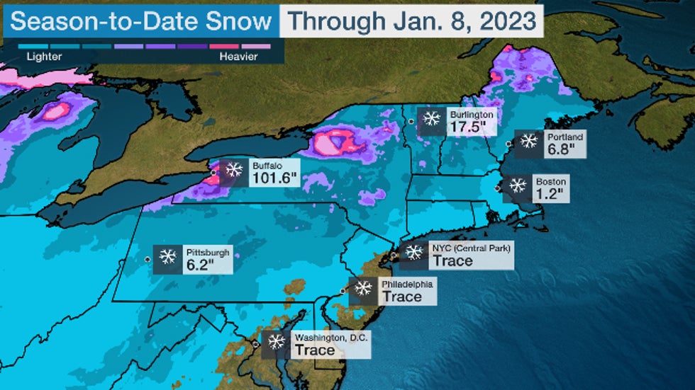
Through Jan. 12, New York City's Central Park has recorded only a trace of snow since fall. That's about 8 inches below their average season snowfall to date.
Usually, the city picks up its first measurable snow (at least 0.1 inches) by mid-December. But it's not unprecedented to wait until January.
It's the 15th time since 1869 that Central Park has failed to pick up any measurable snow through December. That last happened seven years ago, when the season's first slushy accumulations happened on Jan. 17, 2016.
The city's latest "first" accumulating snow of the season happened 50 years ago, when Central Park waited until Jan. 29, 1973.
But the lack of snow isn't confined to New York City.
Philadelphia, Baltimore and Washington D.C. are also awaiting their first measurable snow of the season. Boston's paltry 1.2 inches of snow this season is over 13 inches behind their average pace.
 2022-23 season-to-date snowfall (in inches) from the time of the season's first snow through Jan. 8, 2023.
Why The Lack Of Snow?
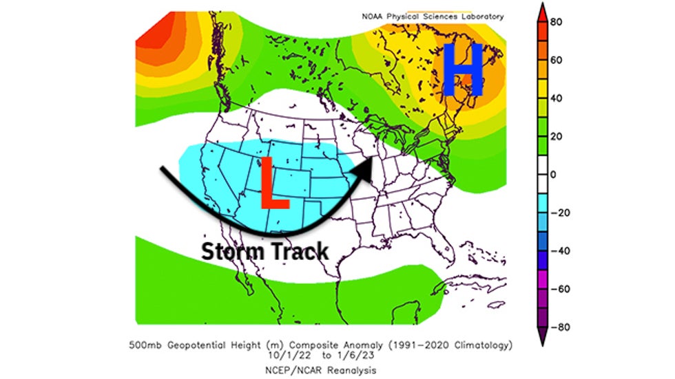
The weather pattern since fall has been most favorable for snow from the Rockies into the Northern Plains.
Namely, low-pressure systems have intensified in the High Plains of the Rockies, then tracked into the northern Great Lakes or eastern Canada. That's a pattern typical of late fall or spring, steering winter storms through, say, the Dakotas.
Meanwhile, high pressure has been stubbornly in place over eastern Canada and the Northeast, keeping much of that area warmer than average.
According to the Southeast Regional Climate Center, the three-month period ending Jan. 8 was among the warmest such early October through early January periods on record in New England.
When cold air has swept into the Northeast, it whipped across the Great Lakes and manufactured two rounds of prolific lake-effect snow in Buffalo and Watertown, New York, in late November and December.
 Anomaly in the upper-level weather pattern over the U.S. and Canada from Oct. 1, 2022 through Jan. 6, 2023. Areas of persistent lower pressure are highlighted by the "L" and the teal contours over the West and Plains. Areas of higher pressure are highlighted by the "H" and the green, yellow and orange contours over eastern Canada and the Northeast.
Heart Of The Season Is Still Ahead
The latest 8- to 14-day outlook from NOAA's Climate Prediction Center continues the much warmer-than-average, but also wetter-than-average East scenario that isn't the pattern to wring out significant snow in the Northeast.
But it's far too soon to proclaim the entire rest of the snow season a dud.
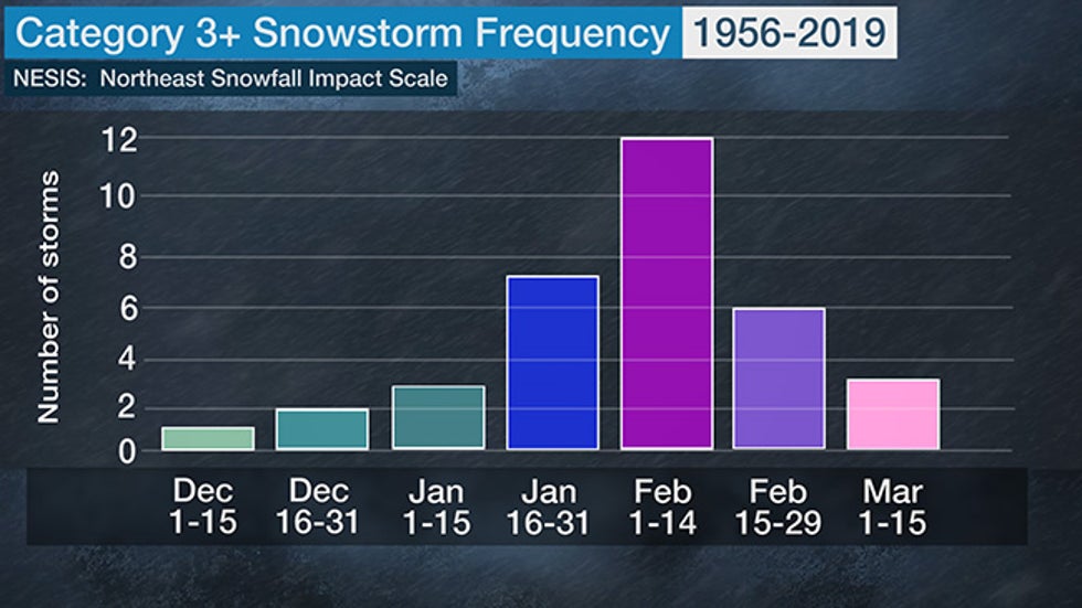
Boston usually picks up two-thirds of its average snowfall after mid-January. New York City's average snowiest month is February (10.1 inches). This typically coincides with the historical peak in major Northeast snowstorms from late January through February.
 The number of major (Category 3 or higher on the NESIS scale) Northeast snowstorms for each two-week period from December through March, from 1956 through 2019.
Also, there are some indications in longer-range models of a change toward the end of January that could set up a somewhat more conducive pattern for Northeast snow, assuming there is enough cold air.
As mentioned earlier, 2016 was the last time New York City waited until January for its first measurable snow of the season. Less than a week after that late-arriving first snow, the East Coast was pummeled by Winter Storm Jonas, a record-setting snowstorm in New York City and several other cities.
We're not saying another Jonas will happen later this month, but it shows how a quiet snow season can turn rather quickly. Whether that snowier pattern change happens, and exactly when, still remains uncertain.
So if you dread shoveling or plowing your sidewalk or driveway, enjoy this extended lack of snow while you can.
The Weather Company’s primary journalistic mission is to report on breaking weather news, the environment and the importance of science to our lives. This story does not necessarily represent the position of our parent company, IBM.
The Weather Company’s primary journalistic mission is to report on breaking weather news, the environment and the importance of science to our lives. This story does not necessarily represent the position of our parent company, IBM.

No comments:
Post a Comment