Jonathan Erdman
A series of California storms has pushed Sierra snowpack to record levels for mid-January and boosted state reservoirs in what has been a stunning turn of events in the drought-stricken area.
At least six separate rounds of rain and mountain snow have drenched the Golden State since the day after Christmas.
In the Sierra, where snowfall measured in feet is typical each winter and spring, this prolonged storm parade has left the snowpack in record territory.
As of Jan. 11, the water content of the state's snowpack was 226% of average, more than twice what it typically is this time of year. In the northern, central and southern Sierra, that snowpack is running at record levels for mid-January in records dating to 1981, topping the pace set in 1982-83, according to the California Department of Water Resources.
The University of California-Berkeley's Central Sierra Snow Lab near Lake Tahoe reported 8 to 9 feet of snow on the ground Tuesday, up to the building's second-floor windows.
Mammoth Mountain – in the southern Sierra near Yosemite National Park – has reported 190 inches (nearly 16 feet) of snow from Dec. 26 through Jan. 11. Their seasonal total – 328 inches – is already more than each of the past three winter seasons since 2019-20.
Heavenly Ski Resort has already topped their average full-season snowfall total of 250 inches.
What's also impressive is the snowpack is already above typical spring levels. As of Jan. 11, Sierra snowpack was 102% of average for April 1. That's when the snowpack typically reaches its yearly peak before melting begins in spring and summer.
Reservoirs Rising
This is important because melting Sierra snowpack is a key source of water for the state, recharging its reservoirs through summer.
However, some runoff from the storm parade's rounds of heavy rainfall has drained into the state's reservoirs, raising levels that were very low heading into last fall.
(MORE: San Francisco's Wettest Stretch In 156 Years)
Five of California's major reservoirs are now running at or above average for mid-January, including Folsom Reservoir, northeast of Sacramento.
Water levels on Lake Oroville, in the Sierra foothills, have risen over 100 feet since Dec. 1, and are pacing higher than one year ago. While some smaller reservoirs have had to conduct small, controlled releases, only one of the state's six largest reservoirs was near its mid-January average, according to the U.S. Drought Monitor report released Jan. 12.
According to an estimation from the California-Nevada Climate Applications Program, the sum of water stored in Sierra reservoirs plus the snowpack is now above average for mid-January.
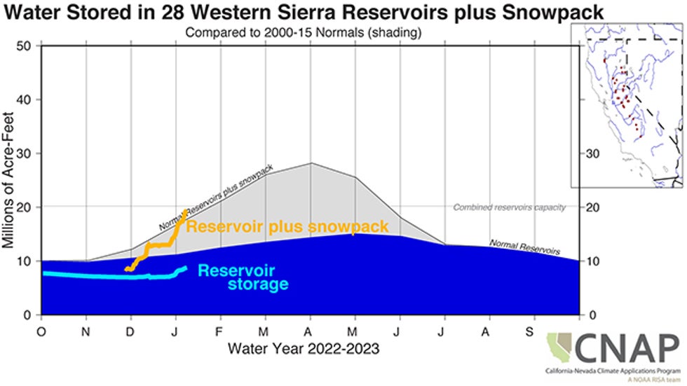 An estimation of Sierra reservoir storage (light blue line) and the reservoir plus Sierra snowpack water content (orange line), compared to an average pace for reservoirs (dark blue shading) and reservoir plus snowpack content (gray shading).
A Different Story The Past Few Years
December through February are typically the wettest months in California, but that hasn't been the case the past several winters.
Last January tied for the second-driest January on record in California. That was after the state's driest water year on record from July 2020 through June 2021.
Spring 2021 was so warm and dry that the Sierra snowpack melted two months earlier than usual in late May before the snowmelt could recharge the state's reservoirs.
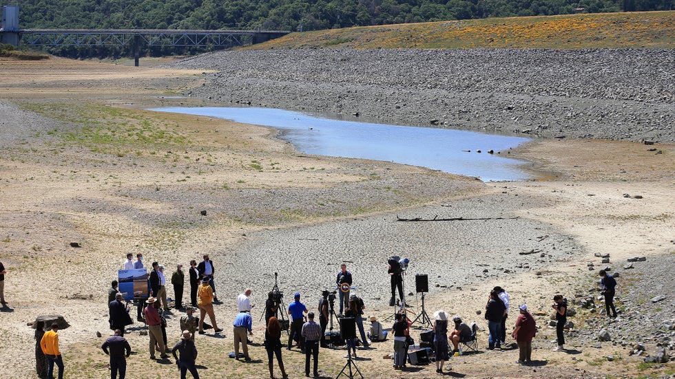 California Gov. Gavin Newsom holds a news conference in the parched basin of Lake Mendocino in Ukiah, California, Wednesday, April 21, 2021, where he announced he would proclaim a drought emergency for Mendocino and Sonoma counties.
Another dry rainy season from fall 2019 to spring 2020 left the state's snowpack in lousy shape by May 2020 and kicked off the current multi-year drought.
Drought Prognosis
Despite the damaging flooding and mudslides, Sierra snowpack already nearing spring levels and higher reservoir levels are both good news for the long-term drought.
However, a somewhat wet pattern needs to last through spring in order to keep chipping away at the long-term drought. California can't hope to erase the drought if the state lurches back to the persistently dry pattern from the past few winters and springs.
Longer-range models suggest a drier pattern may finally set in for a while by the final week of January. This would provide at least a break for the flood-weary state, but it's not clear how long it will last.
NOAA's precipitation outlook through March calls for below-average precipitation in Southern California, but there are mixed signals on whether the first three months of 2023 will be wet or dry in Northern California.
It remains to be seen whether this impressive two-week-plus storm parade is the beginning of the end of California's multi-year drought, or whether it's just a temporary dent.
The Weather Company’s primary journalistic mission is to report on breaking weather news, the environment and the importance of science to our lives. This story does not necessarily represent the position of our parent company, IBM.
The Weather Company’s primary journalistic mission is to report on breaking weather news, the environment and the importance of science to our lives. This story does not necessarily represent the position of our parent company, IBM.


No comments:
Post a Comment