Jonathan Erdman
New York City may finally see its first measurable snow of 2022-23 this week, in what would be their longest wait for the season's first snowfall in 50 years.
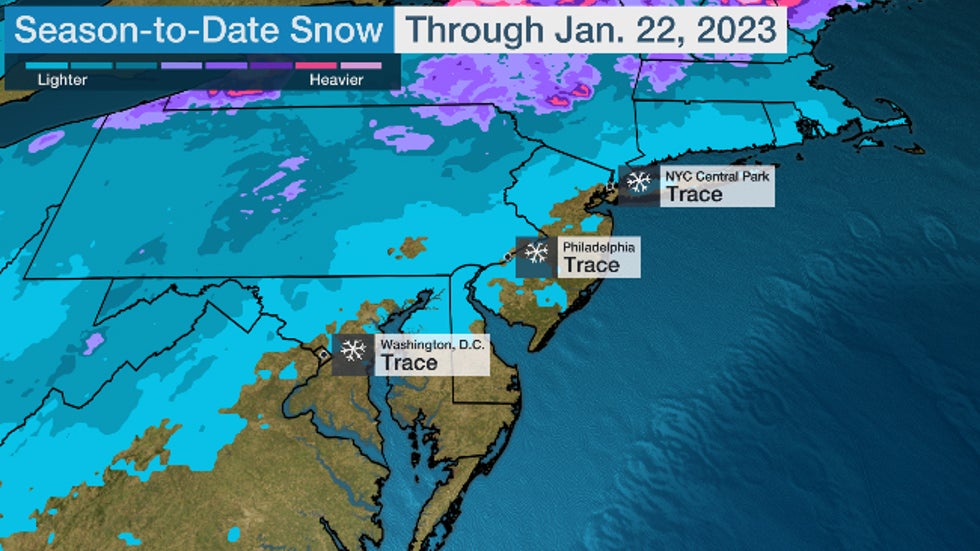
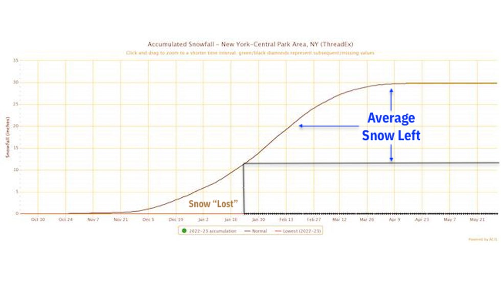
Through Jan. 23, New York City's Central Park has recorded only a trace of snow since fall. That's over 11 inches below their average season snowfall to date.
That's despite a pair of recent storms, named winter storms Iggy and Jimenez by The Weather Channel, which each dumped significant snow in the interior Northeast, but only rain in New York City.
On Wednesday, another winter storm, named Kassandra, will move into the Northeast. This time, cold air could linger for a brief time when the precipitation starts in New York City. That means a few hours of light snow are possible Wednesday before warmer air changes it to rain by late afternoon.
(MORE: New York City's Hourly Forecast)
If Wednesday's storm can't squeeze out a mere 0.1 inches of snowfall, it may be several days before the next chance of snow.
 Snow and Rain Outlook
And that could flirt with an all-time snow dearth record.
New York City's latest first accumulating snow of the season happened 50 years ago, when Central Park waited until Jan. 29, 1973.
Usually, the city picks up its first measurable snow (at least 0.1 inches) by mid-December. Last season, the first measurable dusting arrived on Christmas Eve.
But it's not unprecedented to wait until January.
It's the 15th time since 1869 that Central Park failed to pick up any measurable snow through December. That last happened seven years ago, when the season's first slushy accumulations happened on Jan. 17, 2016.
The lack of snow isn't confined to New York City.
Philadelphia, Baltimore and Washington D.C. are also awaiting the first measurable snow of the season. Philadelphia is nearing its record-long wait for this seasonal first – Feb. 3, 1995 – while both Baltimore and Washington D.C. have previously waited as long as Feb. 21 and 23, respectively, also in 1973.
 2022-23 season-to-date snowfall (in inches) from the time of the season's first snow through Jan. 22, 2023.
Why The Lack Of Snow?
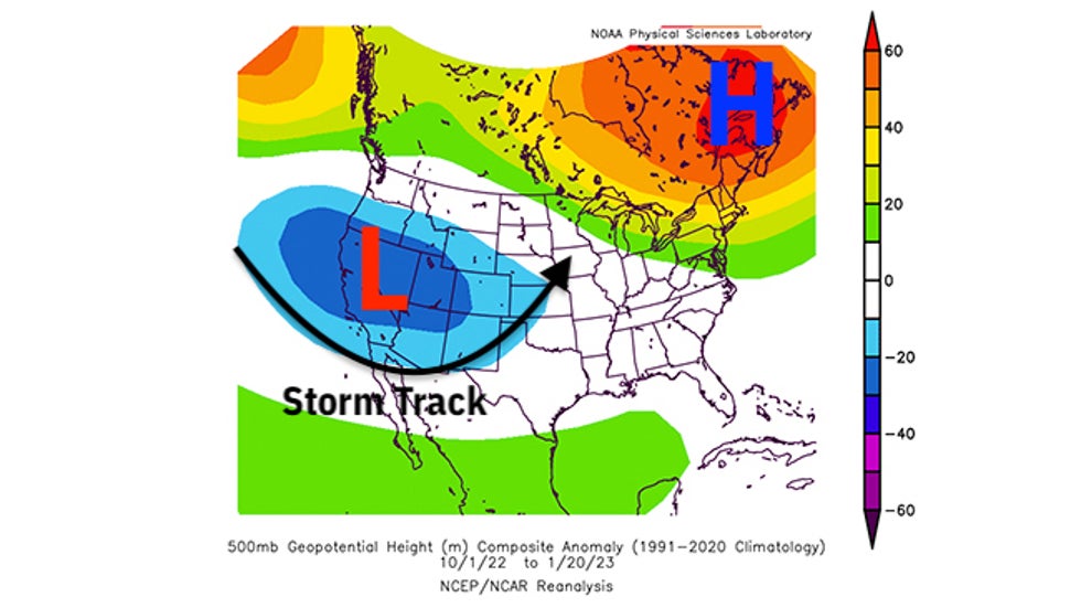
The weather pattern since fall has been most favorable for snow from the West into the Northern Plains.
More specifically, low-pressure systems have most often plowed into the West Coast, intensified in the High Plains of the Rockies, then tracked into the northern Great Lakes or eastern Canada. That's a pattern typical of late fall or spring, steering winter storms through the Dakotas or areas nearby.
Meanwhile, high pressure has been stubbornly in place over eastern Canada and the Northeast, keeping much of that area warmer than average.
 Anomaly in the upper-level weather pattern over the U.S. and Canada from Oct. 1, 2022, through Jan. 20, 2023. Areas of persistent lower pressure are highlighted by the "L" and the blue contours over the West and Plains. Areas of higher pressure are highlighted by the "H" and the green, yellow and orange contours over eastern Canada and the Northeast.
According to the Southeast Regional Climate Center, the three-month period ending Jan. 22 was among the warmest such late October through late January periods on record in the Northeast and New England.
When cold air has swept into the Northeast, it whipped across the Great Lakes and manufactured two rounds of prolific lake-effect snow in Buffalo and Watertown, New York, in late November and December.
And as we alluded to earlier, recent storm tracks have brought snow to the interior Northeast, but have pulled warm air into the Interstate 95 Northeast Urban Corridor, with rain the result.
Snowiest Month Is Still Ahead
Despite this rather snowless scenario, it's far too soon to proclaim the rest of the snow season a dud.
First, some colder air is expected to push into the Northeast next week as the calendar turns to February.
All other factors equal, that could be the difference between the recent wet systems and storms that produce at least some light snowfall in the snow-lacking I-95 corridor.
(MORE: February-April Temperature Outlook)
That's also consistent with February's history.
New York City's average snowiest month is February (10.1 inches). This typically coincides with the historical peak in major Northeast snowstorms from late January through February.
Typically, Central Park picks up two-thirds of its snowfall after Jan. 22. That amounts to just under 19 inches if the rest of the season were average.
 This graph illustrates how much of Central Park's seasonal snowfall has been lost through Jan. 22, 2023 (annotated in brown text), compared to how much typically falls after Jan. 22 (annotated by blue text).
As mentioned earlier, 2016 was the last time New York City waited until January for its first measurable snow of the season.
Less than a week after that late-arriving first snow, the East Coast was pummeled by Winter Storm Jonas, a record snowstorm in New York City and several other cities.
That's not to say another Jonas will happen this season, but it shows how a quiet snow season can turn quickly. Whether a snowier pattern sets up later in February or March still remains uncertain.
So if you dread shoveling or driving in snow, enjoy this extended lack of it while you can.
The Weather Company’s primary journalistic mission is to report on breaking weather news, the environment and the importance of science to our lives. This story does not necessarily represent the position of our parent company, IBM.
The Weather Company’s primary journalistic mission is to report on breaking weather news, the environment and the importance of science to our lives. This story does not necessarily represent the position of our parent company, IBM.

No comments:
Post a Comment