Jonathan Erdman
An area of low pressure off the Northeast coast the past couple of days may have become a subtropical storm that would have been unprecedented for January so close to the Eastern Seaboard in Atlantic Basin records.
This low formed last Saturday along a front draped just off the East Coast.
That sounds like a typical scenario for the middle of winter, in which low pressure strengthens near the East Coast to become a nor'easter, dumping heavy snow in parts of the Northeast.
This low behaved differently.
While some snow fell over parts of eastern New England, the core of the low-pressure center underwent an interesting change.
Over the weekend, patchy areas of thundershowers began to develop near the center of this low. That's not unusual for areas of low pressure that are strengthening.
But beginning on Sunday, winds over the top of this low began to lighten up. That allowed showers and thundershowers to become more numerous and concentrated around the center of the low, rather than getting blown away by strong winds.
By Monday morning, its appearance on satellite imagery resembled a subtropical storm, with deepening thundershowers wrapping around the center.
Later that morning, the National Hurricane Center issued a special tropical weather outlook, in which they acknowledged the thunderstorms near the center, but said "it (the low) is embedded in a cold air mass with nearby frontal boundaries," and "it is unlikely that the low will transition to a tropical or subtropical cyclone."
But that didn't stop the disturbance, dubbed Invest 90L, a naming convention assigned to disturbances monitored for development.
Some meteorologists even noted its satellite presentation resembled an "unnamed hurricane" that eventually developed out of the Perfect Storm in 1991.
This low lost a little intensity, but was still relatively intact when it moved ashore in eastern Nova Scotia Tuesday morning. This was coincidentally not far from where the post-tropical, but intense, remnant of Hurricane Fiona roared ashore in late September.
Why it happened.
To explain why this happened, we first have to explain two main types of large low-pressure systems.
Extratropical - or non-tropical - cyclones are lows you see on weather maps attached to cold, warm and occluded fronts. They get their energy from the contrast between cold and warm air. They're cold in their cores and have their strongest winds far from the center.
Tropical cyclones are the opposite. They derive their energy when water vapor evaporated from warm ocean water condenses into clouds. This heat released means tropical cyclones are warm in their cores, with strongest winds typically near the center.
One type of storm can eventually become the other, or have characteristics of both, a type of hybrid storm known as a subtropical storm.
These subtropical storms typically form in more northern latitudes than tropical storms, since they have some cold and warm core DNA. The National Hurricane Center issues advisories for subtropical depression or storms, as they can evolve into tropical storms, even hurricanes.
In the case of Invest 90L, it may have started out with a cold core. But as thundershowers were able to increasingly cluster near the center, the heat given off gave the system at least a shallow warm core, at least according to model analyses.
But where did the warmth come from in January?
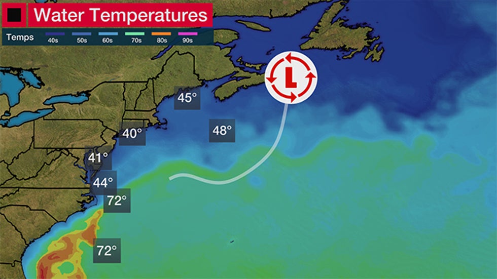
It turned out, 90L was located over the Gulf Stream, a warm ocean current that hugs the Southeast coast of the U.S., then bends east into the Atlantic Ocean.
Ocean temperatures in the Gulf Stream at the time were about 68 to 70 degrees. That's usually not warm enough to support development of a tropical storm, but given the colder air aloft topping air warmed by the Gulf Stream, that generated enough instability to support thundershowers that warmed the core of 90L.
 Western Atlantic Ocean sea-surface temperatures (contours and from some buoy locations shown by the boxes) on Jan. 17, 2023. The track of Invest 90L followed the Gulf Stream before turning north toward Atlantic Canada.
Eventually, 90L turned north toward Nova Scotia on Tuesday. But by that time, it had a solid warm core of thundershowers from its time over the Gulf Stream.
How weird was this for January?
If this was indeed a subtropical storm, it would have been the first on record in this part of the Atlantic Ocean in January.
Only six tropical or subtropical cyclones have been recorded in the entire Atlantic Basin in January, most of which were in the central or eastern Atlantic Ocean.
This last happened in 2016, when a non-tropical low near the Bahamas traveled east across the Atlantic, morphed first into a subtropical storm, then became Hurricane Alex near the Azores.
Hurricane Alice was another January oddball, which slammed into the northern Leeward Islands in early January 1955.
This system may undergo further review later.
After each hurricane season, the National Hurricane Center typically reviews not only named storms and hurricanes from the just-completed season, but also systems that may not have been named at the time to see if they should be added to the historical record.
So it's quite possible that instead of a nor'easter and Northeast snowstorm, we may have witnessed a mid-January subtropical storm off the East Coast for the first time.
The Weather Company’s primary journalistic mission is to report on breaking weather news, the environment and the importance of science to our lives. This story does not necessarily represent the position of our parent company, IBM.
The Weather Company’s primary journalistic mission is to report on breaking weather news, the environment and the importance of science to our lives. This story does not necessarily represent the position of our parent company, IBM.

No comments:
Post a Comment