The storm affecting the Northeast Thursday is a product of the major cross-country system that spawned a travel-snarling snowstorm in the northern Plains and a tornado outbreak in the South.
Lake Placid, New York, a village situated in the Adirondack Mountains and known as the 1980 Winter Olympics venue and a hub for winter sports, is expected to see the brunt of the winter storm with very heavy snowfall rates. Art Devlin, mayor of Lake Placid, told AccuWeather about the area’s snow preparation. He noted that the first big storm of the season can be easier for snow removal, since preventative maintenance programs are right up to speed. “It’s a lot worse when you’ve been at it month after month and haven’t had a chance to get the things that should be on our side,” Devlin said in an interview. The village checks all snow plows and equipment, making sure everything is oiled and greased up. Due to environmental issues, sand is used to create traction on roadways rather than salt, especially around Lake Mirror, the lake within the village.
Lake Placid is no stranger to winter weather. The area sees so much snow in winter that it is dumped in snowfields about 2 miles away when it becomes too much to handle, and Devlin explained that space is on the village’s side. On the other hand, resources are an issue. Plow drivers will sometimes work two days straight, according to Devlin. “These storms all come on the weekends. The people doing the plowing have worked all week and then they’ve got to go back out and work all weekend.” For people visiting the area, Devlin recommended following simple but important tips to stay safe while traveling in winter weather, including slowing down, keeping eyes on the road, being careful and adding more distance between vehicles.
AccuWeather Now - 24/7 Live Stream
Freezing rain, sleet and snow have caused headaches across the mid-Atlantic due to treacherous travel and being left in the dark. As of Thursday afternoon, around 47,000 electric customers were without power across Pennsylvania, West Virginia, Maryland and Virginia, according to PowerOutage.us. Families without power could be without heat in their homes until power is restored. People using generators should ensure that the generator is outdoors in a properly ventilated area to avoid carbon monoxide poisoning.
The snow keeps piling up in the north-central U.S., with towns across North Dakota, South Dakota and Minnesota experiencing near-blizzard conditions. Heavy, blowing snow has created a complete whiteout in Valley City, North Dakota, located 58 miles west of Fargo, North Dakota. However, sustained winds have topped out around 30 mph, 5 mph shy of blizzard criteria. The onslaught of snow and wind is being accompanied by AccuWeather RealFeel® Temperatures below 0 F.
At least two buildings were damaged, including a preschool, after a severe thunderstorm tracked near St. Petersburg, Florida, around midday Thursday. No children at the All Children’s Academy were injured when the storms swept through, but the building may be closed for an extended period due to the damage from the storm, local news station WTSP reported. The National Weather Service is planning on investigating the storm damage to determine if a tornado briefly touched down in the area. The severe weather risk has since ended for the Tampa area, but strong storms and tornadoes will be possible elsewhere in central Florida through the afternoon.
A combination of sleet, freezing rain and snow has been reported from Virginia to New York, on Thursday, and created a mess on roadways. A weather spotter in McHenry, Maryland, which is located in the northwestern part of the state, near the West Virginia and Pennsylvania border, reported 1 inch of sleet. Just south of McHenry, in Deer Park, Maryland, 0.5 of an inch of sleet was measured by a weather spotter as of Thursday afternoon.
Freezing rain, which is different from sleet, has created a glaze over the trees and on the street in multiple states. In Terra Alta, West Virginia, which is located near the Maryland border, 0.4 of an inch of freezing rain has fallen as of Thursday afternoon. East of Terra Alta, in Jerome, West Virginia, 0.30 of an inch of freezing rain has fallen. In Grantsville, Maryland, located near the Pennsylvania border, a storm spotter also measured 0.30 of an inch of freezing rain.
Accidents have been reported across Pennsylvania Thursday morning amid snowy and icy conditions, including a crash on one of the state’s biggest highways. A section of Interstate 76, also known as the Pennsylvania Turnpike, was shut down following a multi-vehicle crash that involved tractor-trailers. The accident forced officials to temporarily close both sides of the Turnpike in south-central Pennsylvania, causing the highway to appear more like a parking lot as traffic backed up behind the accident. Traffic is now slowly moving in the area of the crash, but the Pennsylvania Department of Transportation said on its website that motorists traveling on the eastbound lanes toward the Allegheny Tunnel should be alert for stopped traffic and expect delays due to the crash.
A major accident occurred on Interstate 76, a Pennsylvania turnpike, on Dec. 15, prompting officials to shut down both sides of the interstate as conditions continue to decline.
AccuWeather meteorologists say the heaviest snow will fall across the interior Northeast, with parts of New York, Vermont, New Hampshire and Maine the most likely to receive totals ranging from 12 to 18 inches. Some areas could receive an AccuWeather Local StormMax™ over 24 inches. According to AccuWeather Senior Meteorologist Alex Sosnowski, the winter storm in the Northeast should “treat ski resorts quite well from the Poconos to the Catskills and the Green and White mountains.”

As wintry weather unfolds in the Northeast, severe weather continues to affect parts of the South. A line of severe thunderstorms with gusty winds and frequent lightning is approaching Tampa and Saint Petersburg, Florida, as the multi-day severe weather outbreak shifts its focus to Florida. A quick spin-up tornado cannot be ruled out as the line of storms moves across Florida with a tornado watch in effect until 4 p.m. EST. A travel advisory is in effect for the Sunshine Skyway Bridge due to the risk of high winds as the storms blow through the Tampa region.

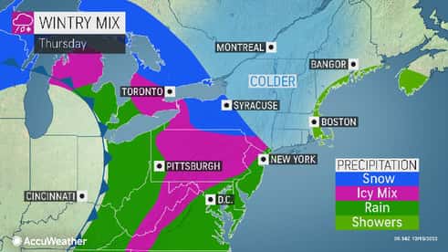
A mix of wintry precipitation is spreading across the interior mid-Atlantic, including sleet and freezing rain, but how are these two types of precipitation different? In both cases, snow falling in a storm encounters a layer of warm air high above the ground, which causes the snow to melt into raindrops.
As the rain continues to fall, it encounters a pocket of cold air where temperatures are below freezing. If there is a thick layer of subfreezing air above the ground, the raindrops freeze into sleet pellets before reaching the surface. If there is a shallow layer of subfreezing air, the raindrops reach the ground as liquid and then freeze after making contact with the ground. Freezing rain can be more dangerous than sleet as freezing rain can weigh down tree limbs and power lines and turn highways into sheets of ice.

It’s a complex setup for the storm in the Northeast on Thursday, with rain, freezing rain, sleet and accumulating snow threatening to cause travel nightmares. AccuWeather Long-Range Meteorologist Joe Lundberg and AccuWeather Chief On-Air Meteorologist Bernie Rayno discussed some of the ongoing threats from the storm on the AccuWeather Network earlier Thursday as well as how it will develop into the evening hours. Lundberg noted that the storm could evolve into more of a “classic nor’easter for New England.” Watch the video below for more.
AccuWeather’s Bernie Rayno and Joe Lundberg break down dangerous winter weather expected to bring snow and ice to the northeastern U.S.
The same system responsible for deadly tornadoes in the South and blizzard conditions in the northern Plains is now moving into the Northeast with a mix of snow, sleet and freezing rain. The worst of the wintry mix is currently focusing on a zone from the mountains of Virginia through central Pennsylvania, making travel conditions very dangerous across the region, including segments of Interstates 80 and 81. Freezing rain is weighing down tree limbs and power lines with reports of widespread ice accumulations between 0.10 and 0.25 of an inch. Officials are encouraging people to avoid unnecessary travel, but motorists that do travel should allow ample time to reach their destination.

Wind and snow have blasted the north-central U.S. this week, bringing travel to a halt and leaving some residents in the dark. As of Thursday morning, 155,000 electric customers across Minnesota, Wisconsin and Michigan were without power, according to PowerOutage.us.
Wisconsin accounted for nearly half of the outages across the region with most of the outages reported in the central and northwestern areas of the state. Over 74% of all residents in Rusk, Sawyer and Washburn counties were in the dark on Thursday morning with over a foot of fresh snow blanketing the counties. Some outages could be lengthy as the ongoing wintry weather could make it challenging for crews to restore power across the region.
Due to forecast winter weather, Pennsylvania State University announced Wednesday evening that all final exams, activities and work at the school are canceled on Thursday.“The decision to reschedule final exams and cancel work and other activities at University Park was determined to be in the best safety interest of the University community,” the school said in a statement. According to AccuWeather forecasters, 0.15 to 0.25 of an inch of ice is expected for State College, Pennsylvania, and 3 to 6 inches of snow is forecast to fall. Final exams scheduled for Thursday, Dec. 15, will be rescheduled to Friday, Dec. 16, and Saturday, Dec. 17. According to the announcement, only employees who perform essential services should report to the university.
For previous storm reports and updates on the severe weather in the south and blizzard conditions in the northern U.S., click here.


No comments:
Post a Comment