weather.com meteorologists
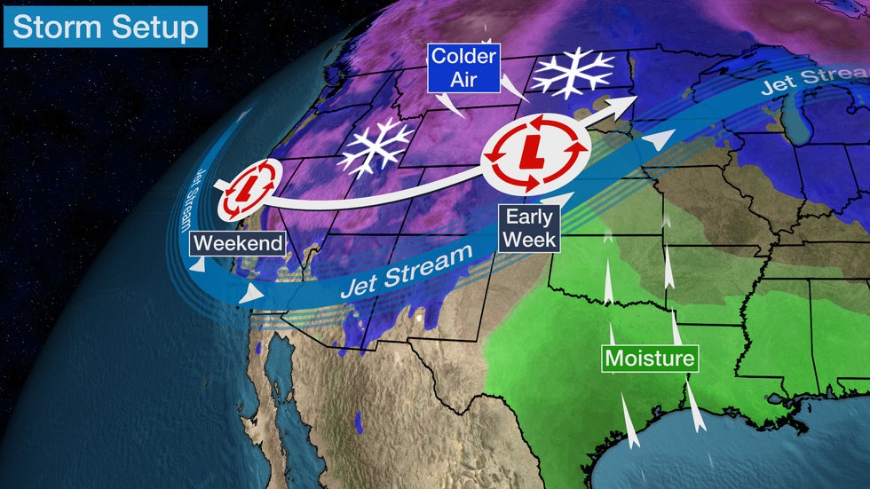
A major winter storm will continue to blanket parts of the West and will become a Northern Plains blizzard, then could dump significant snow in parts of the Northeast later in the week ahead.
This will be the first winter storm that will have impacts from coast to coast so far this season. It has been named Winter Storm Diaz by The Weather Channel. There is also a threat for severe thunderstorms in parts of the South. For details on that, click here.
That's because a powerful, southward plunge of the jet stream will plow eastward across the country into late week.
Let's take a region-by-region look at what to expect and when.
West
This winter storm is sweeping into the Southwest.
More than 20 inches of snow has accumulated in Northern California.
Winter storm warnings have been issued by the National Weather Service from California's Sierra Nevada into the Great Basin and parts of the Rockies. Other winter weather alerts extend into the higher elevations of the Southwest and parts of the Rockies.

In addition to the heavy snow, localized flooding was reported in San Francisco, San Jose and Sacramento along with gusty winds.
The weather caused power outages for tens of thousands of customers in Northern California on Saturday, but many have been repaired.
Forecast Timing
In California's Sierra Nevada, snow will be heavy at times through Sunday, then diminish by Monday.
Snow will spread into the high country of Colorado and northern New Mexico by Monday.
How Much Snow?
Multiple feet of snow have already blanketed parts of California's Sierra.
Elsewhere, over 6 inches of snow is a good bet in much of the West's higher elevations. Some accumulations to valley floors in the Great Basin (Boise, Salt Lake City) will also lead to slippery travel. Check road conditions if you're traveling to the high country.

Northern Plains
Winter storm watches have been issued by the National Weather Service for much of the Northern Plains. Blizzard warnings have already been issued in parts of Nebraska and Wyoming ahead of the storm.
Forecast Timing
This winter storm spreads into the Northern Plains Monday.
Monday night into Tuesday, heavy snow and increasing winds will overspread parts of eastern Montana, eastern Wyoming, western Nebraska, the Dakotas and Minnesota.
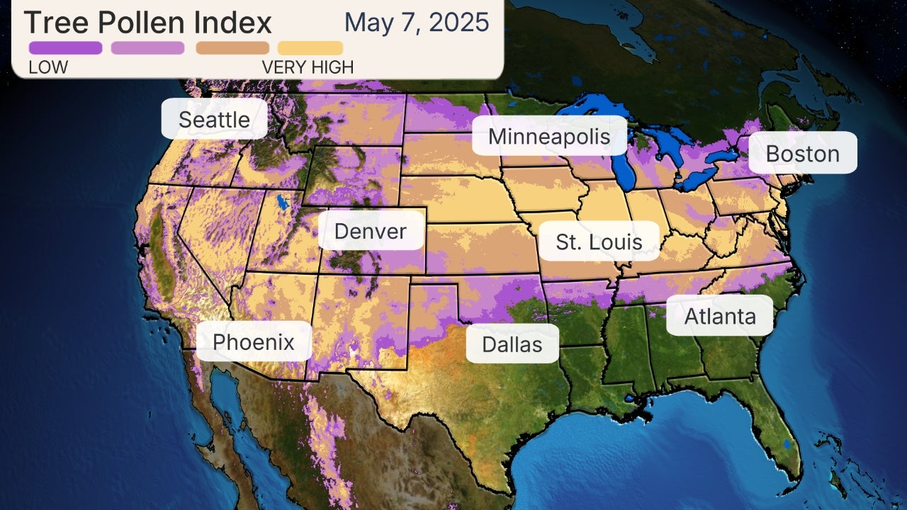
There is some potential for mixed precipitation, including some ice, from eastern portions of South Dakota and Nebraska into northern Iowa and southern Minnesota.

Later Tuesday into Wednesday, that snow may spread into parts of Wisconsin and northern Michigan.
This snow could last through Wednesday or even Thursday from eastern Montana and northern Wyoming through northern Michigan, diminishing slowly from west to east.
How Much Snow
It's still a bit too soon for precise snowfall totals, but given how long this strong storm will last, much of the Northern Plains has a high chance of picking up at least 6 inches of snow.
Much of the Dakotas into southeastern Montana has the best chance of picking up at least a foot of total snow.

Blizzard Threat
This heavy snow will be accompanied by strong winds as low pressure intensifies in the Plains.
Blizzard conditions are possible in some parts of the Northern Plains Monday night into Tuesday, possibly lingering into Wednesday.
This could make travel dangerous – if not impossible – at times, across the Dakotas, eastern Montana, eastern Wyoming, western Nebraska, and western and northern Minnesota. Blowing and drifting snow could reduce visibility and make some roads impassable. Consider ending any travel in these areas by Monday afternoon, or postpone travel plans until after the storm.
Some power outages are also possible due to the force of high winds and the weight of heavy, wind-driven snow.
East
Later in the week, this storm moves toward the East. Here's where the forecast becomes complicated.
First, we expect a couple of early-week cold fronts to deliver at least some cold air to the East ahead of this storm.
That's important because as moisture from the storm begins to override that cold air, some snow, sleet or freezing rain could break out in parts of the East as soon as late Wednesday or Thursday.
(MAPS: U.S. Daily Rain/Snow Forecast)
After that, low pressure is expected to form near or off the East Coast Thursday. Where that low tracks will play a large role in how much, if any, snow the Northeast may pick up, and where it would fall.
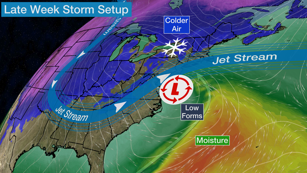
The possibilities range from a low tracking so far out to sea there's little or no additional precipitation anywhere in the Northeast, to a track just offshore but with enough cold air to wring out at least some snow closer to the coast, to a track along the coast or inland with snow mainly in the interior Northeast but rain at least for a time near the coast.
It's far too soon to tell which of these scenarios will occur in the East; Check back for updates as the forecast comes into focus in the next few days.
The Weather Company’s primary journalistic mission is to report on breaking weather news, the environment and the importance of science to our lives. This story does not necessarily represent the position of our parent company, IBM.
The Weather Company’s primary journalistic mission is to report on breaking weather news, the environment and the importance of science to our lives. This story does not necessarily represent the position of our parent company, IBM.


No comments:
Post a Comment