Published: August 30, 2021
Hurricane Ida's terrible pummeling of the New Orleans metro area was the result of a particular final track that hasn't happened for the city in over a century.
Ida's ferocious winds had knocked out power to all of New Orleans by late Sunday, and parts of the metro area experienced flooding from storm surge and heavy rainfall.
The Category 4 hurricane was moving to the northwest at about 15 mph through the northern Gulf as it neared landfall on Sunday. After landfall, the path of the hurricane gradually made a bend more toward the north-northwest and eventually north across southeast Louisiana, as depicted by the red line in the map below.
There are a few reasons why this was a bad outcome for New Orleans.
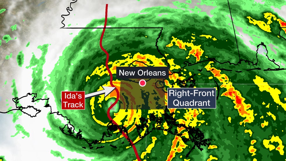 Radar of Ida late Sunday.
First, it put New Orleans in the crosshairs of the hurricane's right-front quadrant. This part of a landfalling hurricane typically packs the most destructive winds, which in this case produced gusts up to 90 mph at the New Orleans International Airport. That's because the storm's forward speed adds to the might of the winds in this part of the storm.
Several Category 3 or stronger hurricanes have tracked within 70 miles of New Orleans, including Katrina in 2005. But the last one to deliver a punishing blow from the right-front quadrant on a northward track to the west of the city happened in 1915, according to NOAA's hurricane database.
Ida also slowed down as it passed west of New Orleans, which prolonged the high winds in the city. Ida was moving at 15 mph before it made landfall. By late Sunday evening, Ida was only moving north-northwest at 9 mph as it tracked near New Orleans.
Wind gusts over 50 mph were clocked at New Orleans International Airport from around 12 p.m. CDT to 8 p.m. CDT. This included multiple hours when wind gusts reached hurricane force.
Serious flooding from storm surge, worsened by heavy rainfall, also happened in the New Orleans metro area because of Ida's track.
Ida's counterclockwise circulation piled up water on the southwest side of Lake Pontchartrain, which sent major storm-surge flooding into LaPlace, which is roughly 30 miles west of downtown New Orleans. The lakefront area in New Orleans also saw flooding from Lake Pontchartrain's storm surge.
The right-front quadrant also pushed storm-surge flooding from the Atlantic up through other parts of southeast Louisiana and coastal Mississippi. That caused a levee to overtop south of New Orleans in Jefferson Parish, allowing floodwaters several feet deep to inundate parts of Jean Lafitte and Lafitte.
The Weather Company’s primary journalistic mission is to report on breaking weather news, the environment and the importance of science to our lives. This story does not necessarily represent the position of our parent company, IBM.
The Weather Company’s primary journalistic mission is to report on breaking weather news, the environment and the importance of science to our lives. This story does not necessarily represent the position of our parent company, IBM.


No comments:
Post a Comment