Published: July 30, 2021
You may have an idea when the hottest time of the year is where you live. A map from NOAA's Climate.gov, shown above, lays out how the average hottest day varies across the Lower 48 states.
(MORE: Your Hottest and Coolest Summer)
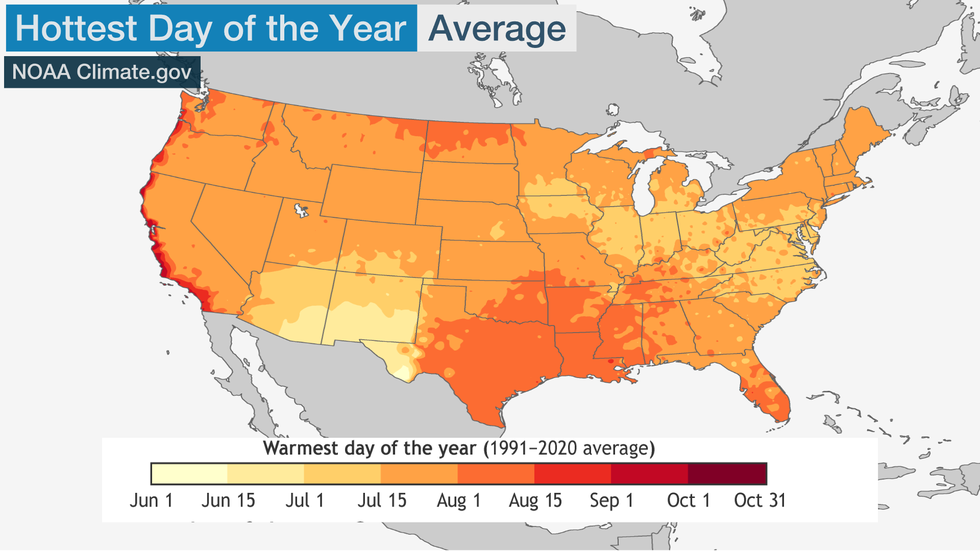 This map shows when the hottest time of year is, on average, across the Lower 48 states.
Of course, these are just long-term averages. In any given year, bulging areas of high pressure aloft can deliver the year's hottest weather a few weeks on either side of the average dates.
There are several interesting features on the map that caught our eye.
After the Summer Solstice, Mainly
With the exception of a swath from the Big Bend of Texas to southeastern Arizona, the hottest time of the year over much of the U.S. arrives days, or in some cases weeks, after the late June summer solstice.
While the sun is highest in the sky, delivering its most direct radiation over the Northern Hemisphere at the summer solstice, it takes multiple days or weeks to warm up the Earth's surface in order to make appreciable changes, and then for the air above it to warm. Thus there's a seasonal lag between the solstice and the typical hottest day of the year.
Speaking of the Desert Southwest
That Big-Bend-to-southeastern-Arizona swath comes relatively early compared to other locations, due to the North American monsoon – a seasonal shift in wind direction bringing increased moisture fueling more frequent showers and thunderstorms as we progress through July.
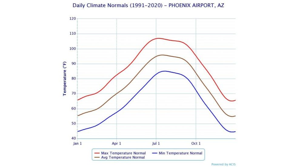 These are the average monthly temperatures for Phoenix, based on 1991-2020 averages.
July for Many
From the central Rockies to the central Plains, upper Midwest, Great Lakes, Ohio Valley and East, July is the warmest month.
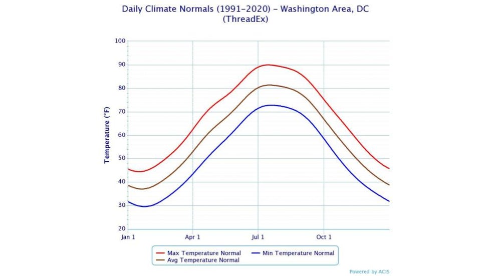 These are the average monthly temperatures for Washington D.C., based on 1991-2020 averages.
August For the Deep South
Early to mid-August tends to be the hottest time for parts of the South from central and eastern Texas into the Ozarks and lower Mississippi Valley.
By that time, the somewhat daily slow-moving thunderstorms of early summer will have given way to more persistent high pressure aloft over the South, suppressing clouds and drying soil, helping temperatures to soar.
(MORE: 4 Summer Dangers to Watch Out For)
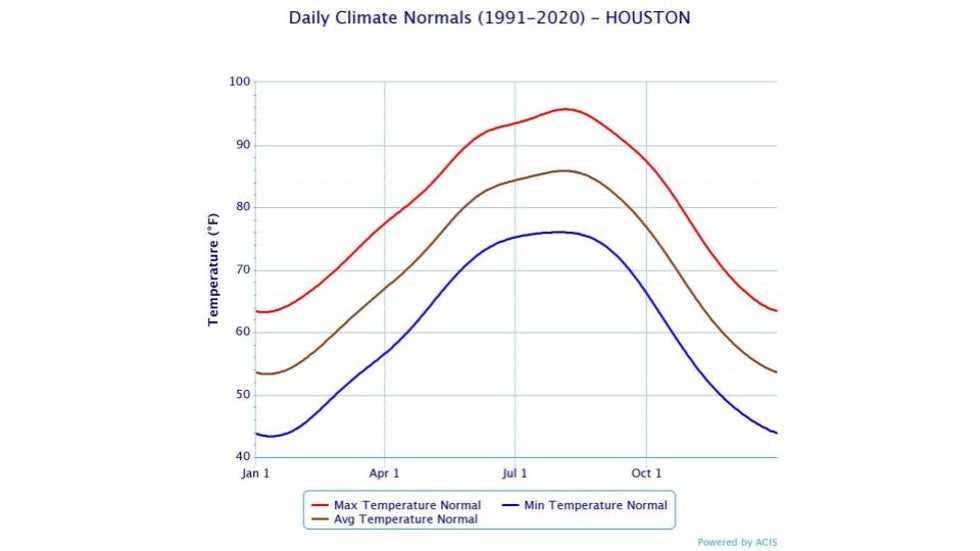 These are the average monthly temperatures for Houston, based on 1991-2020 averages.
Early August is also typically the hottest time along the northern tier of states from northwest Minnesota North Dakota to parts of Washington state.
West Coast Lag
A few locations along the West Coast aren't typically their warmest until September.
In the heart of summer, the combination of the hot interior deserts and cool air over the ocean drives winds onshore along the coast, keeping low clouds, fog and cool air firmly in place.
By September, the upper-level wind pattern can set up to drive hot, dry winds from the deserts to the coast and offshore, known as Santa Ana winds in Southern California and Diablo Winds in the Bay Area.
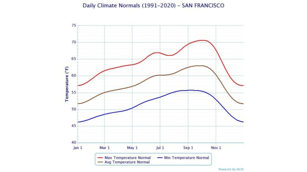 These are the average monthly temperatures for downtown San Francisco, based on 1991-2020 averages.
What About Alaska and Hawaii?
July is generally the warmest time of the year for much of Alaska, but along the southern coastal areas, peak warmth doesn't occur until the last week of July into August.
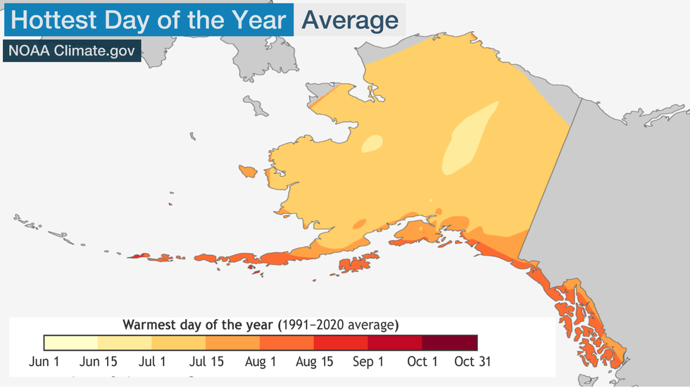 This map shows the average warmest day of the year across Alaska.
In Hawaii, most areas don't see their warmest time of the year until August or September. Some high-mountain locations see peak summer temperatures much earlier, however, in July or even June.
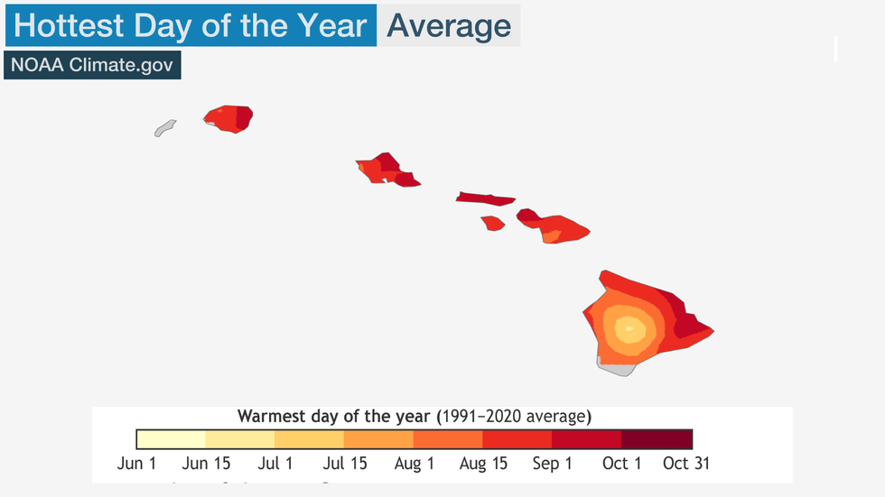 This map shows the average warmest day of the year across Hawaii.
The Weather Company’s primary journalistic mission is to report on breaking weather news, the environment and the importance of science to our lives. This story does not necessarily represent the position of our parent company, IBM.
The Weather Company’s primary journalistic mission is to report on breaking weather news, the environment and the importance of science to our lives. This story does not necessarily represent the position of our parent company, IBM.

No comments:
Post a Comment