Chris Dolce
The recent siege of snow and cold deep into the South has created a topsy-turvy pattern that's evident in a key winter severity index as we head into the final stretch of the season.
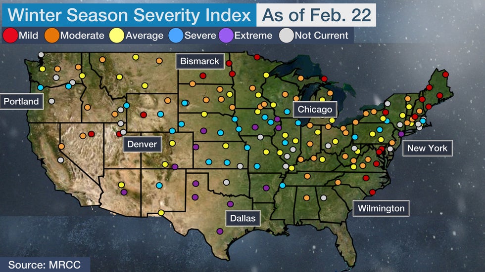
This winter's cold and snow as of Feb. 22 has been severe to extreme, the two most serious measurements, for numerous cities from parts of the Central Plains and Midwest to Texas and Arkansas, according to the Accumulated Winter Season Severity Index (AWSSI) from the Midwest Regional Climate Center.
A few spots in the Northeast and the Pacific Northwest have also had a winter that ranks in those categories, including New York City and Portland, Oregon, respectively.
Meanwhile, the combo of winter's snow and cold has been relatively mild for a number of locations near the Canadian border, like from North Dakota to Maine.
 The status of the winter severity index as of Feb. 22, 2021.
This index, also known as the winter misery index, takes into account the "intensity and persistence of cold weather, the frequency and amount of snow and the amount and persistence of snow on the ground," the Midwest Regional Climate Center says. Wind and mixed precipitation, such as freezing rain, are not a part of the index.
SPONSORED: Winter sale at Columbia Sportswear
The index uses five categories – mild, moderate, average, severe and extreme – to rate the severity of winter weather in cities across the U.S.
February Fuels "Extreme Jump"
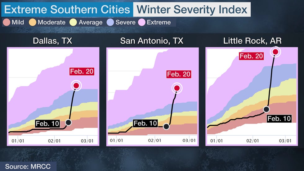
The graphs below show the recent jump to the extreme category in the index for Dallas-Fort Worth, San Antonio, Texas, and Little Rock, Arkansas. All of those locations were having a mild winter to date until the arrival of last's week's barrage of snowfall and severe cold.

But some northern cities have also jumped this February.
A much colder than average and snowy February vaulted Chicago from the mild to severe category in about 10 days. The Windy City has picked up 21.6 inches of snow in February, more than twice the average for the entire month.
New York City is the only eastern city in the extreme category. It jumped to the index's extreme level after Winter Storm Gail in mid-December, but then fell back to the average and moderate categories by January. The recent lurch back to extreme is largely due to the Big Apple's eighth-snowiest February (25.6 inches) dating to 1869.
In the Northwest, Portland, Oregon, has picked up 9.6 inches of snow in February, fueling its jump from the mild to severe category this month.
Topsy-Turvy North
February's long-lasting arctic cold plunge wasn't enough to lift some locations near the Canadian border out of the mild category.
Part of the reason is that winter was trending much warmer than average prior to February in cities like Bismarck and Grand Forks, North Dakota, and International Falls, Minnesota. Snowfall is also much below average to date in those cities.
In the Northeast, Syracuse, New York, and Bangor, Maine, stand out as locations near the Canadian border that are having a mild winter. Part of the reason for that is that snowfall in those cities is between 60% to 70% of average so far this winter.
The Weather Company’s primary journalistic mission is to report on breaking weather news, the environment and the importance of science to our lives. This story does not necessarily represent the position of our parent company, IBM.
The Weather Company’s primary journalistic mission is to report on breaking weather news, the environment and the importance of science to our lives. This story does not necessarily represent the position of our parent company, IBM.

No comments:
Post a Comment