Chris Dolce
Drought conditions in parts of the Southwest have intensified by up to five times in the last year and the prospects for significant relief are slim for the foreseeable future.
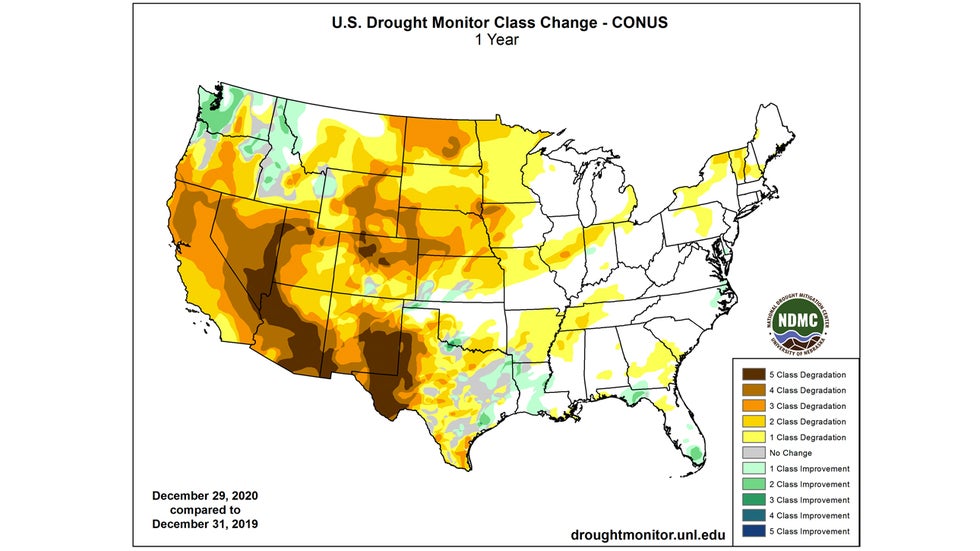
The final U.S. Drought Monitor report of 2020 released last week shows how U.S. drought conditions now compare to those from a year ago. This is depicted in the map below, which shows the change in drought conditions by class, or category, across the U.S. in the one-year period ending Dec. 29, 2020.
An increase in the severity of the drought by two to five categories over a large area of the Southwest over the last year is most noticeable.
SPONSORED: Need to get away? Here are Expedia's best travel deals
Areas that saw drought intensify by five categories weren't even in a drought this time a year ago, including parts of southwest Texas, southern New Mexico, Arizona, eastern Nevada and small parts of Utah and Colorado. Now they are in exceptional drought, the worst drought category.
 The change in drought class, or category, from Dec. 31 2019 to Dec. 29, 2020.
You can see this drought intensification even clearer in the animation below. It shows how drought changed in the Southwest from the end of March to late December in 2020.
The Southwest emerged from early spring with some areas of moderate and severe drought. Now the region is covered by widespread extreme and exceptional drought, the two worst categories.
 Drought comparison late March to late December in 2020.
One of the main reasons this happened is that showers and thunderstorms fueled by moisture from the summertime monsoon barely made an appearance in 2020. That's important since most of northwestern Mexico and the southwestern U.S. receive over half of their annual precipitation from the monsoon.
Late fall through winter and early spring is the Southwest's other wet season, but it's had a slow start as well.
Parts of Southern California and the Four Corners region picked up some modest rain and mountain snow relief early last week, but overall, the storm track has been shunted north of these areas so far this season.
Through November, Arizona, California, Colorado, Nevada, New Mexico and Utah are all on pace to have a top-five driest year in 2020, according to NOAA. Final rankings for the year as a whole will arrive on Thursday.
No Significant Near-Term Relief
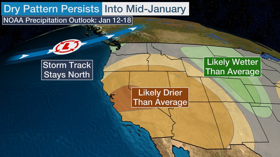
We are in the midst of the wintertime wet season in the Southwest, but the weather pattern into mid-January won't cooperate by bringing heavy rain and mountain snow.
The storm track, or jet stream, will likely remain pointed at parts of the Northwest and western Canada through at least mid-month. That means the odds are tilted toward drier than average conditions persisting during this time in the southwestern quarter of the nation, according to the 8- to 14-day outlook (Jan. 12-18) from NOAA's Climate Prediction Center.
A deep, southward plunge of the jet stream located near or just off the California coast would be more favorable for drawing moisture and storminess into the region. Until that happens, this drought in the Southwest will only intensify.

The Weather Company’s primary journalistic mission is to report on breaking weather news, the environment and the importance of science to our lives. This story does not necessarily represent the position of our parent company, IBM.
The Weather Company’s primary journalistic mission is to report on breaking weather news, the environment and the importance of science to our lives. This story does not necessarily represent the position of our parent company, IBM.

No comments:
Post a Comment