Jonathan Erdman
A nor'easter is developing along the U.S. East Coast and will bringing rain, wind and snow to parts of the Northeast.
Similar to the storm earlier this week, named Winter Storm Dane by The Weather Channel, this weekend nor'easter is expected to develop from the teaming up of energy from two jet streams.
(MORE: What is a Nor'easter?)
However, this weekend's storm, now named Winter Storm Eartha by The Weather Channel, will track much farther east than the storm earlier this week.
This means some areas that were soaked with heavy rain earlier this week may instead see snow. Other areas hammered with snow earlier in the week may see little precipitation. However, some areas may once again see a soaking this weekend as they did earlier.
Winter storm warnings have been issued by the National Weather Service for parts of New England from Massachusetts to Maine where heavy snow will make travel conditions difficult dangerous this weekend.
Winter weather advisories are also in effect in parts of Vermont and Connecticut, where travel could be tricky.
 Current Winter Weather Alerts
We also expect this low-pressure system to intensify Saturday near the Eastern Seaboard, possibly rapidly enough to satisfy the criterion for a bomb cyclone by later Saturday.
 Forecast surface pressure from the GFS forecast model for a 24-hour period ending early Sunday morning, Dec. 6, 2020. The white lines are isobars, lines of equal barometric pressure. The deeper orange and red contours show progressively lower pressure forecast by the model.
This rapidly intensifying storm will bring disruptions to travel, damage to tree limbs and some power outages from Massachusetts to Maine this weekend. Some locations in Maine and central Massachusetts may see more extensive disruptions.
 Winter Storm Severity Index
Let's start by laying out the timing of the storm, then the snow, rain and wind forecasts.
Friday
The low pressure system is beginning to strengthen as it moves eastward.
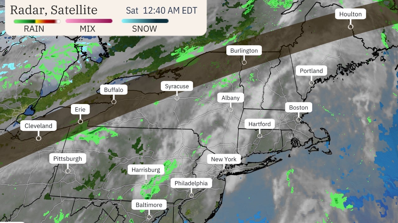
Rain is spreading through the Appalachians, mid-Atlantic and Northeast. Some flurries are also falling across the interior Northeast.
 Current Radar and Pressure
A few severe thunderstorms are possible late Friday night through Saturday morning in eastern North Carolina as this winter storm intensifies. A tornado or two are not out of the question.
Saturday
Low pressure will intensify and track from near the Mid-Atlantic coast to off the New England coast by evening.
The exact track of the low will be crucial for determining any impacts. That includes where the rain-snow line will set up and the strength of winds this system might produce.
The best chance of wind-driven rain will be in coastal and southeast New England and Long Island. However, rain may change to some snow later Saturday and Saturday night in parts of southern New England.
(MORE: Northeast Urban Corridor 'High-Impact Snowstorm' Drought Enters Third Winter)
Rain should end by afternoon from New Jersey southwestward.
 Saturday's Forecast
The best chance of snow will stretch from interior southern New England north into parts of Vermont, New Hampshire, northern, central and western Maine.
Strong winds are likely throughout the Northeast, particularly in coastal New England, as this system intensifies near the coast. Power outages may be possible.
The National Weather Service has issued a high wind warning Saturday afternoon and evening in parts of southeast Massachusetts, including Cape Cod, Martha's Vineyard and Nantucket, where gusts from 50 to 60 mph will likely down some trees and knock out power. Some coastal erosion and minor flooding is also possible along north and east-facing coasts.
Strong wind gusts over 50 mph are also possible Saturday and Saturday night in Long Island, over higher terrain of New England, and along the coast of Maine.
Power outages and tree damage are also possible from the weight of heavy, wet snow and winds in the aforementioned parts of northern New England.

Sunday
By Sunday morning, most computer models suggest low pressure will be heading into New Brunswick or Nova Scotia, Canada.
Lingering snow is expected in parts of Maine and possibly over the high country of northern New Hampshire and northern Vermont.
Gusty winds may also linger in New England and possibly other parts of the Northeast.
 Sunday's Outlook
Snow, Rain Forecast
Most locations along the I-95 corridor will at least start as plain rain, which could be heavy at times.
There is still some uncertainty on the exact track the nor'easter takes near the Northeast Coast, which could affect the exact placement of both the rain/snow line and heaviest snow as this storm intensifies.
The best chance of heavier snow totals, in excess of 6 inches, is over much of Maine, except the immediate coast, as well as New Hampshire. Snowfall rates of 1 to 2 inches per hour are possible in intense, small-scale snowbands.
(MORE: 6 Things to Know About Your Snowfall Forecast)
The most uncertainty in snowfall amounts is over southern New England, given the uncertain low track and marginal supply of cold air.
If precipitation changes to snow earlier and/or the low tracks a bit farther east, heavier snow may fall in southern New England, particularly in Massachusetts. For now, we expect mainly rain in downtown Boston, but a few inches may accumulate, especially in the north and western portions of town.
Lighter snow accumulations are expected in most of Vermont, parts of upstate, central and western New York, and the Appalachians.
Rain is expected along the Interstate 95 corridor from Hartford to Washington D.C. Locally heavy rainfall is possible, but only isolated, minor flash flooding is expected.
(MORE: Northeast High-Impact Snowstorm Drought Enters Third Winter)
 Rain, Snow Forecast
The Weather Company’s primary journalistic mission is to report on breaking weather news, the environment and the importance of science to our lives. This story does not necessarily represent the position of our parent company, IBM.
The Weather Company’s primary journalistic mission is to report on breaking weather news, the environment and the importance of science to our lives. This story does not necessarily represent the position of our parent company, IBM.


No comments:
Post a Comment