Chris Dolce
Weather records are set every year in the United States, and they can cover a wide array of extreme conditions ranging from heat and drought to snowfall and cold. In 2020, hurricane season also played a big role in rewriting weather history.
Occasionally, there are records set over the course of a year that leave meteorologists speechless. Here's a look back at 10 of those moments in 2020.
1. Record-Breaking December Snowstorm
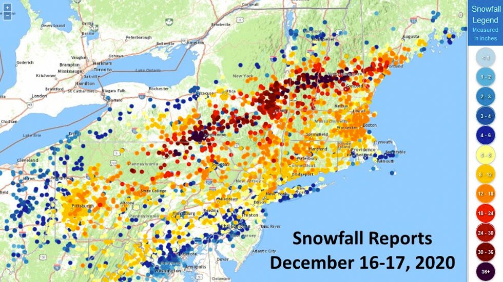
The most recent entry on this list is a record-breaking snowstorm that hit the Northeast on Dec. 16-17.
Winter Storm Gail dumped 40 inches of snow at the Greater Binghamton Airport in south-central New York. This makes it Binghamton's heaviest snowstorm on record, topping the previous record of 35.3 inches set during Winter Storm Stella on March 14-15, 2017.
Binghamton averages 81.8 inches of snow each winter season. This winter storm produced roughly half that seasonal average in less than 24 hours.
It's also possible the winter storm might have set new 24-hour snowfall records in two states: Vermont and Pennsylvania.
A preliminary storm total of 44.8 inches was measured in southern Vermont near Peru. This total would top Vermont's all-time state 24-hour snowfall record (42 inches at Jay Peak on Feb. 5, 1995), according to NOAA.
Pennsylvania's top snow total was 43.3 inches near Alba in the north-central part of the state. If that total is confirmed, then it would easily bypass the state's current record for most snowfall in 24 hours – 38 inches.
For these snow totals to be recognized as new state 24-hour records, they will have to be examined at a later date by a State Climate Extremes Committee, an ad hoc committee of meteorologists and climatologists.
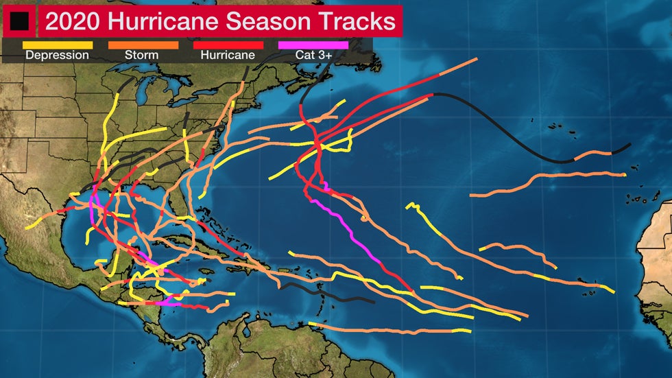
2. Thirty Named Storms Sets Atlantic Record
Hurricane season arguably had the most mind-blowing record set in 2020.
The Atlantic Basin produced 30 named storms for the first time on record, with 13 of those becoming hurricanes. That topped 2005, which previously had the most storms in a season – 28.
Of the record 30 named storms this season, 27 were the earliest formation for their respective number.
For just the second time in history, the Greek alphabet was used to name storms after the original list of names ran out in September. Three of the Greek names – Eta, Theta and Iota – were used for the first time.
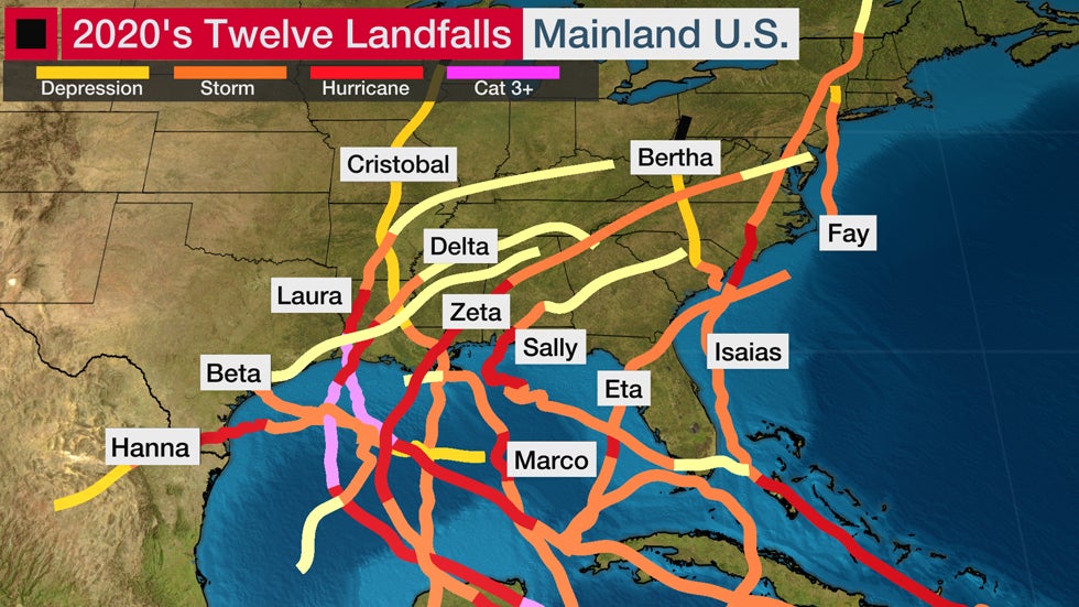
3. Twelve U.S. Landfalls
A record-breaking 12 named storms made a U.S. landfall in 2020. That's 40% of all the storms that roamed the Atlantic Basin this year.
The previous record for most U.S. landfalls in a season was nine set in 1916, according to Dr. Phil Klotzbach, a tropical scientist at Colorado State University.
At least one named storm made a U.S. landfall each month from May through November, beginning with Bertha in South Carolina and ending with Eta in Florida.
Six of the U.S. landfalls were from hurricanes: Hanna, Isaias, Laura, Sally, Delta and Zeta. That's well above the average of one to two hurricane landfalls per year, according to NOAA's Hurricane Research Division.
4. May Had Its Fewest Tornado Watches
May's tornadic reputation went silent in the Great Plains this year.
Just 10 tornado watches were issued in the month, the fewest for May in 50 years of records, according to NOAA's Storm Prediction Center.
May has averaged 281 tornadoes over the past 20 years. This year's preliminary count for the month was about half of that total, according to NOAA's Storm Prediction Center.
May also followed one of the most active Aprils on record, during which an Easter outbreak spawned as many tornadoes in two days (140) as the preliminary total for May.
5. Phoenix Has Its Most 100-Degree Days
Triple-digit summer heat in Phoenix is a given, but 2020 took it to a level never observed before in the city's 125 years of weather records.
Phoenix logged 145 days of 100-degree heat in a 174-day period from late April to mid-October. That broke the previous record of 143 days set in 1989.
The annual average number of days Phoenix sees highs at the century mark or above is 110.
6. All-Time Record Warmth Repeats in Northern Maine
Caribou, Maine – one of the northernmost towns in the continental U.S. – had a persistent theme in the second half of 2020: all-time record warmth.
It began when Caribou tied its all-time high-temperature record for any day of the year as the city hit 96 degrees on June 19. Weather records in Caribou date to 1939, but the NWS noted other northern Maine locations soared to 100 degrees in heat waves prior to 1939.
Caribou also had its most 90s for a year with nine such days from May into August. The persistent heat propelled the city to its hottest summer on record.
The unusual warmth didn't end there.
On Nov. 10, Caribou crushed its all-time high for November when it hit 75 degrees. That's more on par with the city's average high on July 4.
That was followed up by Caribou hitting the 60s for the first time on record in the month of December. The high temperature was 60 degrees on Dec. 1, topping December's previous record high of 58 degrees from 1950.
7. From 100 Degrees to Record Earliest Freeze
The Front Range of Rockies has a reputation for major temperature changes in a short amount of time, but what happened in September took it to a record-breaking level.
Denver hit 101 degrees on Sept. 5, the latest in the year that the Mile High City has hit the century mark since records began. Just three days later on Sept. 8, Denver tied its record earliest first freeze, previously set on that day in 1962.
Denver also had its second-earliest measurable snow on Sept. 8. That snowfall shattered the city's previous record for the fewest number of days (38 days in 2019) between the final 100-degree day of the year and the first measurable snow.
Several other records were set in this extreme weather pattern change, as listed in the tweet below from the National Weather Service.
8. San Francisco Goes Rainless in February
February 2020 was completely dry in San Francisco for just the second time in the city's long weather history.
Until this year, the only other completely dry February was in 1864, just 14 years after California became a state.
February is in the heart of the Bay Area's wintertime wet season, so going rainless in the month is highly unusual. On average, San Francisco has nearly a dozen days with measurable rain in February.
Including February 2020, the winter months of December, January and February have been rain-free a combined total of five times.
A diversion of the jet stream is what made February so dry this year. High pressure aloft near or off the California coast was unusually strong, pushing the storm track northward into the Pacific Northwest.
9. Vegas Crushes Record Dry Streak
Las Vegas ended an astonishingly long dry streak in the closing weeks of 2020.
McCarran International Airport, the city's official reporting station, did not observe measurable rain (0.01 inches or greater) for 240 consecutive days this year. The dry stretch began April 20 and finally ended Dec. 17.
This easily beats the previous record streak without measurable rain in Las Vegas of 150 days set from Feb. 22 to July 21, 1959, according to the NWS.
Part of the reason for this long stretch of dryness – the summertime monsoon brought very little rainfall in the Southwest this year. Of the minuscule number of showers and thunderstorms it produced, none of this activity dropped anything more than a trace of rain on Las Vegas.
10. Miami's Misery
2020's weather in South Florida was filled with new heat records and plenty of rain.
As of Dec. 20, Miami was on pace to have its warmest year on record, according to data from the Southeast Regional Climate Center. If that sounds familiar, it's because 2019 tied 2015 and 2017 for the warmest year in the city's weather records.
A final ranking on where Miami will finish among its hottest years will be available when the year comes to a close.
The year has set numerous notable warm records. Here are a few of them as of Dec. 20:
-Daily record temperatures (record warm highs, record warm lows) have been broken or tied a combined 64 times this year.
-The week ending June 28 had the hottest average temperature of any seven-day period on record in Miami dating to 1895, according to Eric Blake, a senior hurricane scientist at the National Hurricane Center.
-Miami failed to drop below 80 degrees for the first time on record in April.
Rainy weather has added to the misery.
2020 is now the third-wettest year on record in Miami with 86.47 inches of rainfall as of Dec. 20. That ranks just behind 2012 and 1959, which had 86.94 and 89.33 inches of rain, respectively.
The Weather Company’s primary journalistic mission is to report on breaking weather news, the environment and the importance of science to our lives. This story does not necessarily represent the position of our parent company, IBM.
The Weather Company’s primary journalistic mission is to report on breaking weather news, the environment and the importance of science to our lives. This story does not necessarily represent the position of our parent company, IBM.


No comments:
Post a Comment