Linda Lam
It may still be November but the snowfall in some locations is off to a strong start so far this season.
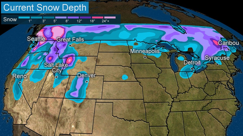
Unsurprisingly, the current snow depth is greatest in the higher elevations of parts of the Rockies and Cascades. A few inches of snow also covers the ground across parts of the northern tier near the Canadian border and in the higher elevations of the Sierra.
Just under 9% of the Lower 48 was covered by snow on Nov. 22, 2020, according to NOAA. This is the least amount of snow cover on this date since 2012, when just over 6% of the contiguous U.S. was covered by snow. Last year at this time, over 20% of the Lower 48 was snow covered.
It was a different story just last month. North America's snow cover was the greatest for October since records began in 1967, according to David Robinson from the Rutgers University Global Snow Lab. Snow fell as far south as part of Texas.
 Estimated Snow Depth on Nov. 23, 2020.
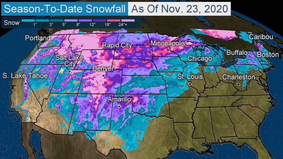
Boston received 4.3 inches of snow Oct. 30. Typically, Boston has picked up 0.6 inches as of Nov. 23.
However, so far this season much of northern New England and upstate New York, as well as parts of the Midwest have seen less snow than average. Warmer than average temperatures have dominated the recent weather pattern here. Alpena, Michigan, is experiencing its warmest November on record.
A bit farther north and west, parts of the upper Midwest and Northern Plains have experienced more snow than average this fall. Minneapolis, for instance, has seen 18.1 inches of snow. That's 11.5 inches above average.
(MORE: Winter Outlook)
 Estimated snowfall from July 1 to Nov. 23.
The story in the West varies greatly. Much of the southern and central Rockies into Utah have not seen as much snow as is expected for this time of year. The recent pattern has brought drier than average conditions and above average temperatures. Denver has been more than 7 degrees warmer than average so far this month.
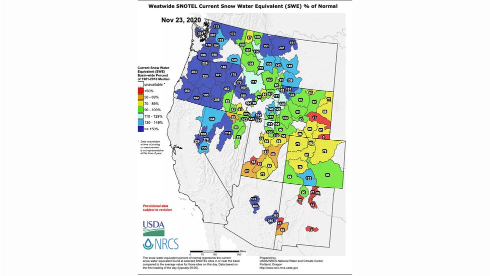
But snowfall has been plentiful in most of the Northwest. Snow water equivalent across much of Nevada, Idaho, western Wyoming, Montana, Oregon and Washington is above average. In some areas, the snow water content is more than double what's expected in late November.
Several low pressure systems have brought an influx of moisture to the northwestern U.S., allowing snow to accumulate in the higher elevations. However, early in the season one storm can make a big difference.
 Status of the snowpack in the West, shown as a percentage of average water content of snow, as of Nov. 23, 2020. Areas in blue are above average for the date, while areas in yellow, orange and red are below average.
Drought Improvement?
The moisture in the West is good news for the wildfires and the ongoing drought.
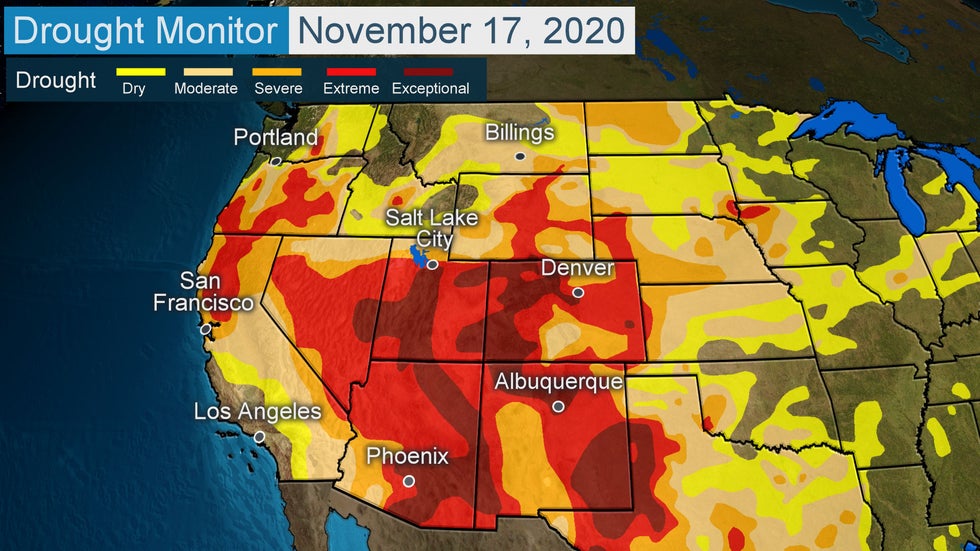
Drought expanded and worsened across most of the West during the summer and early fall. More than 85% of the West is at least abnormally dry with three-quarters of the region in moderate drought. Just over 12% of the West is in the highest drought category.
Drought conditions have also developed in much of the Plains and Northeast, although those conditions have improved recently in parts of the Northeast.
 Areas in red are in extreme and exceptional drought as of Nov. 17, 2020.
What does all this mean going forward?
For those in the West who rely on mountain snow to replenish reservoirs, it's great to see a snowy pattern in November. However, in other areas, it's concerning to watch a dry and warm pattern dominate at this time of year.
La Niña is anticipated to be in place this winter. That often means drier than average conditions across the southern tier, which would not help the drought in the Southwest.
(MORE: Here's What La Niña May Mean for the U.S. This Winter)
Wetter than average conditions are typically prevalent in the Northwest during a La Niña winter. The strong start to the snowpack in the Northwest may be a sign of things to come this winter.
The Weather Company’s primary journalistic mission is to report on breaking weather news, the environment and the importance of science to our lives. This story does not necessarily represent the position of our parent company, IBM.
The Weather Company’s primary journalistic mission is to report on breaking weather news, the environment and the importance of science to our lives. This story does not necessarily represent the position of our parent company, IBM.

No comments:
Post a Comment