Winter could begin cold in parts of the central and eastern states but then transition to a milder finish, according to an outlook released Thursday by The Weather Company, an IBM Business.
Above average temperatures are expected in most locations from the southern and eastern states to the West Coast. Parts of Montana and North Dakota are the only areas where somewhat colder than average temperatures are expected.
But each month of this winter, December through February, could have temperature fluctuations that differ from this overall trend.
 The overall temperature outlook for December, January and February combined.
The expectation that La Niña conditions will continue is one of the drivers in this winter forecast. La Niña is the cooling of sea-surface temperatures in the equatorial Pacific Ocean that can affect weather patterns in the United States and other parts of the globe.
"The typical La Niña response is for warm November, cold December, and warm January/February; however, January and February can have significant volatility depending on if high-latitude blocking occurs," said Todd Crawford, chief meteorologist at The Weather Company.
Atmospheric blocking can cause changes to the jet stream pattern that remain locked in a long time. When that happens, the effects of La Niña, or its counterpart El Niño, can be overridden.
"Winter weather can be quite volatile, and much of that volatility is driven by blocking of the typical west-east flow of the jet stream," Crawford said. "This blocking allows cold high pressure to descend into the mid-latitudes from the Arctic, as the jet stream amplifies and becomes more wavy."
Here's how temperature patterns in the United States might evolve from December through February.
December
The greatest chance for any widespread colder than average temperatures this winter is in December from parts of the Northern Plains and Midwest into the mid-Atlantic and the Southeast.
Warmer than average temperatures are most likely from the Southern Plains and Southwest into the Pacific Northwest.

January
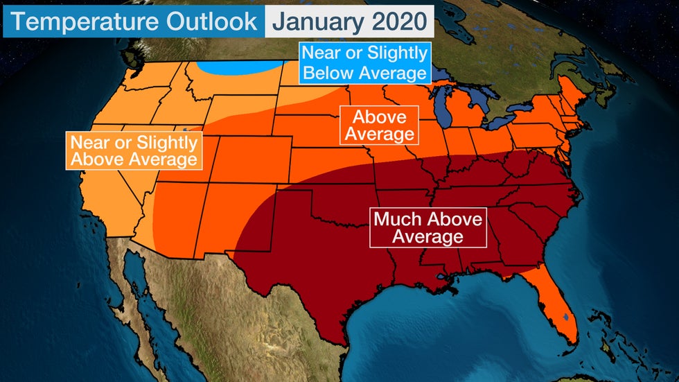
What is typically the coldest month could be quite mild for a large part of the eastern two-thirds of the nation.
Temperatures in the nation's southern half, from the Southern Plains into the Southeast and southern mid-Atlantic, are expected to be much above average. Only northern Montana is expected to have colder than average temperatures.
But this forecast could change if the atmospheric blocking "wild card" shows signs of developing.
"January is the most variable of the winter months, and is more dependent on the existence (or not) of blocking. While three of the four warmest Januaries in the last 20 years were associated with La Niña, there were also two exceptionally cold years with significant blocking in 2009 and 2011," Crawford said.
While there is high confidence that La Niña conditions will persist this winter, it's too early to pin down the details of any other atmospheric influences.

February
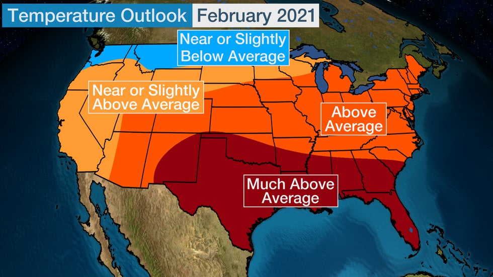
February's forecast also calls for mild conditions to prevail in much of the southern and eastern states. Above or much above average temperatures are forecast across these areas.
Parts of the Pacific Northwest into Montana have the highest chance of seeing colder than average temperatures.
"February has less variability, and is skewed towards the warmer side, with notable warm events during the last three La Niña winters and no exceptionally cold months," said Crawford.

NOAA also released their winter outlook on Oct. 15, noting similar expectations found in The Weather Company's forecast. You can watch the NOAA forecast here:
La Niña's Typical Snowfall Influence
One of the questions always asked heading into winter is how much snowfall there will be in a particular region or city. Finer details like these are impossible to predict far in advance.
But there are some general themes in regard to snowfall in a La Niña winter, according to research by Dr. Stephen Baxter, a meteorologist with NOAA's Climate Prediction Center, published in 2017.
Generally, La Niña favors increased snowfall over the Northwest and northern Rockies, as well as in the upper Midwest Great Lakes region, and less snow in the central-southern Plains, Southwest and mid-Atlantic. according to Baxter.
This is shown using blue (above-average snowfall) and brown (below-average snowfall) shadings in the graphic below.
 Snowfall departure from average for all La Niña winters (1950-2009), based on analysis at the Climate Prediction Center using Rutgers gridded snow data. Blue shading shows where snowfall is above average, and brown shows where snowfall is below average.
For more on La Niña's typical influence on snowfall patterns in winter, check out this article in our archive from 2017.
The Weather Company’s primary journalistic mission is to report on breaking weather news, the environment and the importance of science to our lives. This story does not necessarily represent the position of our parent company, IBM.
The Weather Company’s primary journalistic mission is to report on breaking weather news, the environment and the importance of science to our lives. This story does not necessarily represent the position of our parent company, IBM.

No comments:
Post a Comment