Chris Dolce
Hurricane Delta is expected to bring a dangerous storm surge to the Louisiana coastline just weeks after Hurricane Laura's push of surge water devastated southwest parts of the state.
Because the worst storm surge in a hurricane is typically located in areas near and just east of where landfall occurs, exactly where Delta's center makes landfall within its projected path could mean the difference between one area of the Louisiana coast getting inundated with feet of storm surge water and another area just miles away being spared from the worst.
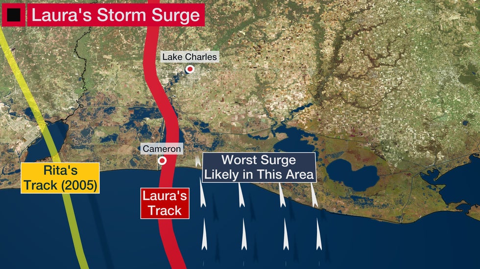
We saw a prime example of this during Hurricane Laura, which brought a major storm surge to the Louisiana coast but spared some larger cities, like Lake Charles, from a flooding catastrophe due to its final track.

Laura made landfall near Cameron, Louisiana, on Aug. 27. A maximum storm surge of just over 19 feet was measured to the east of Cameron during a National Hurricane Center post-storm survey, according to Rob Perillo, chief meteorologist at KATC-TV.
Perillo said that during the survey he found a five-mile stretch near Grand Cheniere where 15 to 18 feet of water swept ashore during the peak of Laura's surge.
Laura's final track produced destructive winds in Lake Charles from the hurricane's eyewall, but was just far enough east to spare the metro area a much worse fate from surge flooding. That's because the track prevented a big south-to-north push of Gulf of Mexico water from heading northward tens of miles into Calcasieu Lake and then the Calcasieu River, which flows toward Lake Charles.

West to southwest winds to the south of Laura's center did pile water into previously dry parts of downtown Lake Charles several hours after landfall. A peak storm surge of around 4.65 feet was measured by a gauge by Lake Charles' downtown.
For comparison, Laura's landfall location was only about 25 miles farther east than Hurricane Rita in 2005 (yellow line above). Rita's further west track allowed storm surge waters to flood areas farther west along the Louisiana coast, including parts of the Lake Charles area 15 years ago.
Port Arthur was also spared from a storm surge catastrophe for the same reason as Lake Charles. The track was too far east, which allowed winds there to blow from a northerly or westerly direction during the height of the storm, or off of land instead of the Gulf of Mexico.
The bottom line is that, while Laura caused severe wind impacts, the storm surge could have been much worse in higher-populated areas like Lake Charles and Port Arthur if the Category 4 hurricane tracked just to the west of those cities.
This storyline is something that should be monitored once again with Hurricane Delta forecast to bring feet of storm surge to parts of the Louisiana coast.
Massive evacuations in cities can be a hassle for some residents, but they are a necessity since there are usually subtle differences in a hurricane's future track even less even than 24 hours before landfall. That can mean the difference between dealing with a potentially deadly storm surge or escaping the worst.
The Weather Company’s primary journalistic mission is to report on breaking weather news, the environment and the importance of science to our lives. This story does not necessarily represent the position of our parent company, IBM.
The Weather Company’s primary journalistic mission is to report on breaking weather news, the environment and the importance of science to our lives. This story does not necessarily represent the position of our parent company, IBM.

No comments:
Post a Comment