Chris Dolce
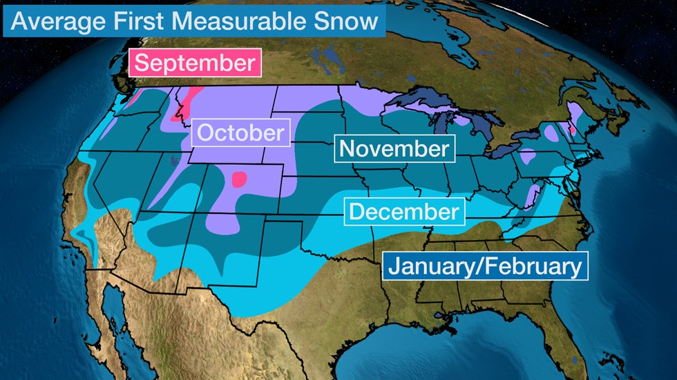
 Month of the average first accumulating (0.1 inch or greater) snowfall of the season, according to 30-year average statistics.
Snowstorms that strike early in the season can be damaging, and this week is providing another example as snowfall spreads through parts of the Rockies and the Front Range.
Early Tuesday morning, trees and limbs were downed in Lead, South Dakota, after 10 inches of snowfall. The storm system could produce similar impacts as it spreads through Colorado.
That's because the heavy, wet nature of most early season snow can weigh down tree branches and power lines, causing them to break.
Many trees also still have their leaves, adding extra weight to branches weighed down by snow.
Any gusty winds accompanying the storm adds stress to snow-covered trees and power lines, creating a potentially destructive situation.
Here are some other recent examples of damaging early-season snowstorms.
2019: Feet of Snow in Late-September
A historic late-September 2019 storm blasted parts of the northern Rockies with heavy, wet snow and high winds, leading to power outages and tree damage.
More than a dozen locations in northern Montana picked up over a foot of snow. The highest snowfall total was 48 inches (4 feet) in Browning, Montana, about 105 miles northwest of Great Falls. East Glacier Park measured 24 inches of snow.
In Great Falls, Montana, the snowstorm not only shattered September records, but it was also one of their heaviest snowstorms of all time.
The two-day total of 19.3 inches Sept. 28-29 was second only to April 27-28, 2009 (24.2 inches) for the city's all-time heaviest two-day snowfall, the National Weather Service in Great Falls tweeted.
Tree limbs were reported down on "most, if not all, side streets" due to the weight of 16 inches of wet snow and winds in Choteau, Montana, about 45 miles northwest of Great Falls along the Rocky Mountain Front Range, according to a report relayed to NWS-Great Falls.
Up to 19 inches of snowfall was reported near the northeastern Washington town of Boyds, damaging a "significant amount of the surrounding trees," according to a report received by the NWS. Parts of northern Idaho picked up 9 inches of wet snow, and numerous power outages were reported, according to Avista Utilities.
2017: Early-October Blizzard Strikes Montana
Montana was hit by another early-season snowstorm that brought blizzard conditions in the first few days of October 2017. The storm's heavy snow and strong winds knocked out power and caused tree damage in parts of the state.
Havre, Montana, was buried by 13 inches of snow Oct. 2-3, 2017, making it the heaviest October two-day snowstorm there in more than 100 years of records. The entire town lost power because of the trees and power lines downed by heavy, wet snow and high winds.
Rocky Boy, Montana, saw the heaviest snow with an estimated total of 30 inches. Drifts in at least one location were estimated to be 8 feet high.
2013: Winter Storm Atlas Brings Blizzard Conditions, Tree Damage, Power Outages
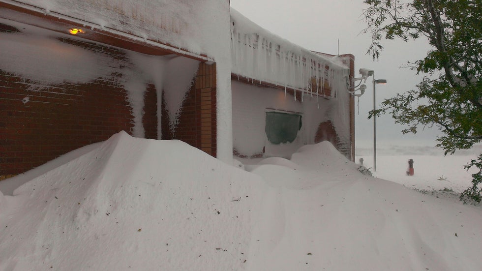
 Snow drifts several feet deep at the National Weather Service office in Rapid City, South Dakota, after Winter Storm Atlas.
Winter Storm Atlas pummeled the northern High Plains and northern Rockies with feet of snow and fierce wind gusts to 70 mph Oct. 3-5, 2013.
The top snow total from the storm was 58 inches - or nearly 5 feet - in northwest Lawrence County, South Dakota. Ellsworth Air Force Base in South Dakota clocked the top wind gust at 71 mph. Needless to say, the combination of heavy snow and strong winds led to blizzard conditions in some areas, resulting in road closures, tree damage and power outages.
Rapid City, South Dakota, was one of the locations that saw blizzard conditions, with visibility dropping as low as one-eighth of a mile. First responders in Rapid City were overwhelmed with calls for stuck vehicles and downed trees and power lines making some roads impassable, according to the Associated Press.
Tree damage and power outages were also reported in Wyoming. Casper saw its heaviest snowstorm so early in the season with 16.2 inches.
The storm had a major impact on ranchers in the region, causing them to lose thousands of cattle.
Because of the widespread heavy snowfall, NOAA rated Atlas as a Category 3 winter storm on its Regional Snowfall Index for the Northern Rockies and Plains region.
2012: Superstorm Sandy's Moisture Fuels 3 Feet of Snow in the Appalachians
 An ambulance stuck in snow Oct. 30, 2012, near Belington, West Virginia.
Moisture from Superstorm Sandy in combination with cold air from a southward dip in the jet stream over the eastern states buried parts of the Appalachians with up to 3 feet of snow, from Pennsylvania to North Carolina. More than 50 locations saw at least a foot of snow Oct. 28-31, 2012.
The heavy, wet snow caused tree damage, knocked down power lines and closed roads in the region. Some roofs collapsed under the weight of the snow in West Virginia.
2011: "Snowtober" Knocks Out Power to 3 Million
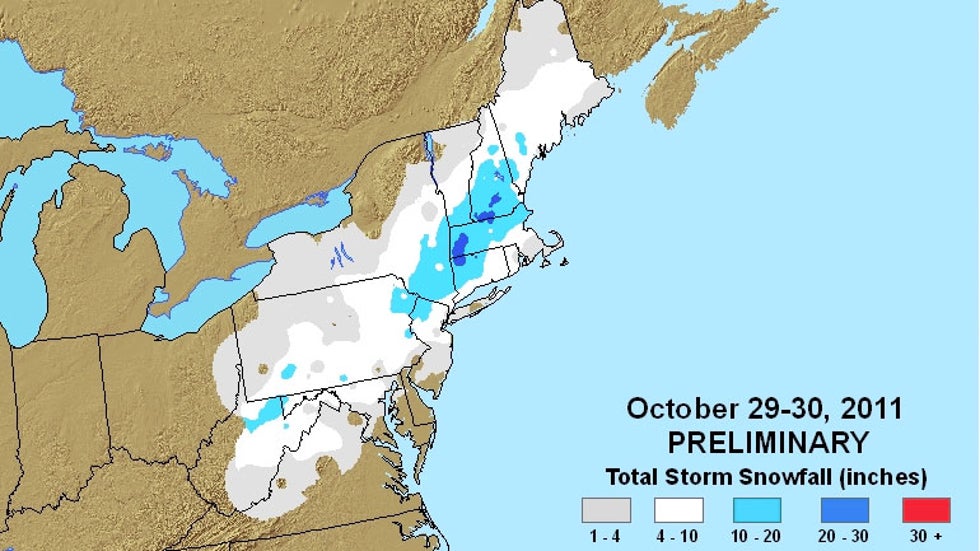
 Snowfall totals from the Oct. 29-39, 2011 nor'easter.
This rare, major October snowstorm dumped more than a foot of snow from northeast Pennsylvania to southern Maine Oct. 29-30, 2011. Incredibly, parts of Massachusetts and New Hampshire saw more than 30 inches.
Trees were damaged and power lines were downed by the heavy, wet snow, causing more than 3 million to lose power. In some of the hardest-hit areas, power was out for more than a week. Playing a role in the tree damage caused by "Snowtober" was the fact that many trees still had their leaves.
A storm event review by NOAA says that 39 direct and indirect deaths were blamed on the storm.
The name "Snowtober" was widely used to refer to the storm by those following it on social media and elsewhere.
2006: Buffalo Crippled by Lake-Effect Snow
 Local residents watch as crews clear fallen trees Oct. 16, 2006, in Amherst, N.Y., a suburb of Buffalo, N.Y. (John Normile/Getty Images)
While the other recent October snowstorm examples above are of the large-scale variety, this next one occurred on a more localized scale almost 14 years ago.
A band of heavy lake-effect snow pummeled the Buffalo, New York, area Oct. 12-13, 2006, downing trees and power lines, and knocking out power to about a million customers in the area. As we've seen with the other storms above, many trees still had their leaves, worsening the impacts of the snow. In fact, there was already plenty of damage reported with just the first few inches of snow that fell, the National Weather Service (NWS) in Buffalo said.
The storm total of 22.6 inches in Buffalo easily beat the all-time previous October monthly snowfall record of 6 inches in 1909.
Lightning and thunder were constant during the height of the storm, according to the NWS. This was due to the very unstable environment in place with relatively mild lake waters at 61 degrees, and an air mass that was just cold enough aloft to produce the heavy snow.
The Weather Company’s primary journalistic mission is to report on breaking weather news, the environment and the importance of science to our lives. This story does not necessarily represent the position of our parent company, IBM.
The Weather Company’s primary journalistic mission is to report on breaking weather news, the environment and the importance of science to our lives. This story does not necessarily represent the position of our parent company, IBM.

No comments:
Post a Comment