Linda Lam
A pattern shift will develop this weekend resulting in record heat in parts of the West and mild and wet conditions dominating parts of the central and eastern United States.
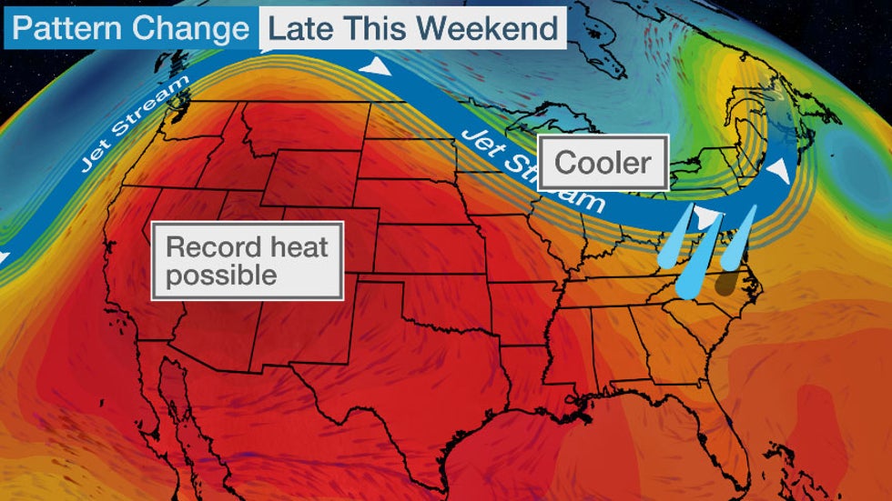
The jet stream will become more amplified late this weekend into next week. In this case, it means the jet stream will bulge northward over the West as a heat dome builds. Then, the jet stream will dip southward over the East.
This setup will bring record hot temperatures to parts of the western U.S., while portions of the Plains and Midwest will experience cooler-than-average conditions. In addition, rounds of rain and storms are likely in parts of the East, keeping temperatures near or slightly cooler than average.
 Pattern Late This Weekend Into Next Week
Western Heat
A strong ridge of high pressure will build over the Southwest and Southern Plains this weekend. This heat dome will expand across the West into next week.
In the Northwest and Northern Rockies, this record heat will replace record cool temperatures.
High temperatures will be up to 25 degrees above average from the Southern Plains to the Northwest this weekend, with the exception of some areas near the California coast. This corresponds to highs in the 90s and 100s for most of the region, including areas as far north as Seattle at times.
Temperatures will return to near average by early next week in the Southern Plains, but most areas from the Rockies westward will continue to experience hotter-than-average temperatures into at least midweek. However, a cold front will bring some heat relief to the Northwest during the middle of next week.
 Forecast Highs
Numerous daily record highs and record warm lows are likely, especially from Texas into Southern California into this weekend. Several days of record heat are possible in Phoenix, which is already experiencing its hottest summer on record so far and has recorded the most 110-degree days in a calendar year. Phoenix tied its August record high of 117 degrees on Friday.
Downtown San Francisco obliterated its former record high on Friday by hitting 95 degrees, compared to its former record of 86 for the date.
(MORE: Missing Monsoon Has Led to Growing Drought, Record Heat)
This heat will also be dangerous in many locations.
Excessive heat warnings, watches and heat advisories have been issued from the Southern Plains into the Northwest by the National Weather Service. Extreme heat of this magnitude significantly increases the potential for heat-related illnesses.
 Heat Alerts
Mild Plains, Midwest and East
Farther east, the southward dip in the jet stream will bring cooler-than-average conditions to the Northern and Central Plains, as well as parts of the Midwest early next week.
Highs will be 5 to 15 degrees below average, with many locations reaching only into the 70s and lower 80s. It may feel more like fall than summer in some spots.
Areas farther east will also see temperatures near or slightly cooler than average, in part due to clouds and rain. This includes the Northeast which will get a break from the recent heat and humidity.
 Forecast Highs
Low temperatures will also be cooler than average. Widespread lows in the 50s are anticipated from the Northern Plains into the Midwest early next week. Temperatures may dip into the 40s near the Canadian border.
(MAPS: 10-Day Forecast)
The cooler trend may persist through mid-August in portions of the Midwest, South and East, where NOAA's Climate Prediction Center has highlighted as having a 50% chance of below-average temperatures. The West is also highlighted as likely having the above-average temperature trend continue during this period.
 Temperature Outlook
Wet East
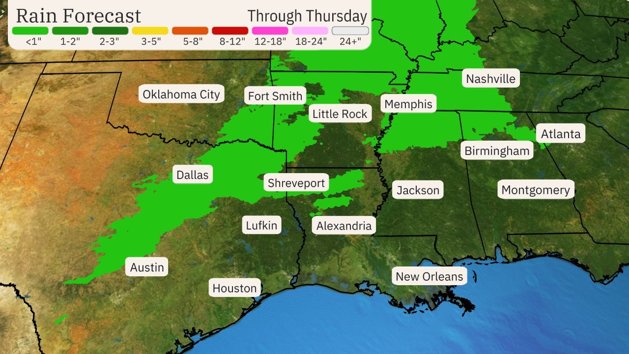
The jet stream pattern will allow multiple disturbances to bring rounds of rain and thunderstorms to the East and South into next week.
The chance for rain will be most persistent in the mid-Atlantic and Southeast through early next week. This is also where the heaviest rainfall is anticipated.
Locally heavy rainfall could lead to flash flooding, particularly in areas that have already seen recent heavy rainfall.
(MORE: More Rain Is Ahead for the Soggy East)
 Rainfall Outlook
A few strong to severe thunderstorms are possible from parts of the Plains to the Midwest into Saturday, as a cold front slides eastward.
Drier conditions, however, will emerge in the Midwest by early next week behind this cold front.
The Weather Company’s primary journalistic mission is to report on breaking weather news, the environment and the importance of science to our lives. This story does not necessarily represent the position of our parent company, IBM.
The Weather Company’s primary journalistic mission is to report on breaking weather news, the environment and the importance of science to our lives. This story does not necessarily represent the position of our parent company, IBM.


No comments:
Post a Comment