 The blue shadings in the box show the development of cooler than average sea-surface temperatures in the equatorial Pacific Ocean as of early July.
La Niña conditions could develop later this year and influence the Atlantic hurricane season as well as temperature and precipitation patterns in the U.S., according to an outlook issued by NOAA on Thursday morning.
La Niña is the periodic cooling of the equatorial eastern and central Pacific Ocean. It's the oceanic opposite of El Niño, which is the warming of sea-surface temperatures in this same region.
The interaction of La Niña and El Niño conditions with the atmosphere can affect weather conditions in the U.S. and around the world.
In the image above, you can see areas of cooler than average sea-surfaces temperatures in the blue shadings across parts of the equatorial Pacific Ocean region. The cooler water in this region has not satisfied NOAA's criteria for this to qualify as a La Niña event yet.
"We've been monitoring the emerging La Niña event for a few months now, and have observed anomalous easterly winds in the tropical Pacific that are helping to drive the oceanic cooling that is the primary characteristic of a La Niña event," said Dr. Todd Crawford, chief meteorologist at The Weather Company.
NOAA says there is a 50% to 55% chance that La Niña conditions will develop by this fall and persist through the winter ahead. For this reason, NOAA has now issued a La Niña watch, which means conditions are favorable for the development of La Niña within the next six months.
"Based largely on dynamical model guidance, the forecaster consensus slightly favors La Niña development during the August-October season, and then lasting through the remainder of 2020," NOAA said in its outlook.
NOAA said that its probability of La Niña's development is conservative because there is a lack of a large supply of cooler water below the surface of the tropical Pacific Ocean. Cooler water rising from below the ocean's surface is what causes La Niña to develop.
La Niña and Hurricane Season
The potential for La Niña to develop as soon as August to October is important since that's the peak of hurricane season. When La Niña is present, it can be a speed boost to the Atlantic hurricane season, but it is just one factor that can lead to an active year. Hurricane seasons can be active even if La Niña is not in play.
La Niña typically corresponds with a more active hurricane season because the cooler waters of the Eastern Pacific Ocean cause less wind shear and weaker low-level winds in the Caribbean Sea. La Niña can also enhance rising motion over the Atlantic Basin, making it easier for storms to develop.
"As tropical season ramps up, the atmospheric pattern associated with this new La Niña event will favor a very active season," Crawford said.
 When La Niña is present, it typically reduces hurricane activity in the Eastern Pacific Ocean and increases hurricane activity in the tropical Atlantic Ocean.
La Niña and Typical U.S. Winter Impacts
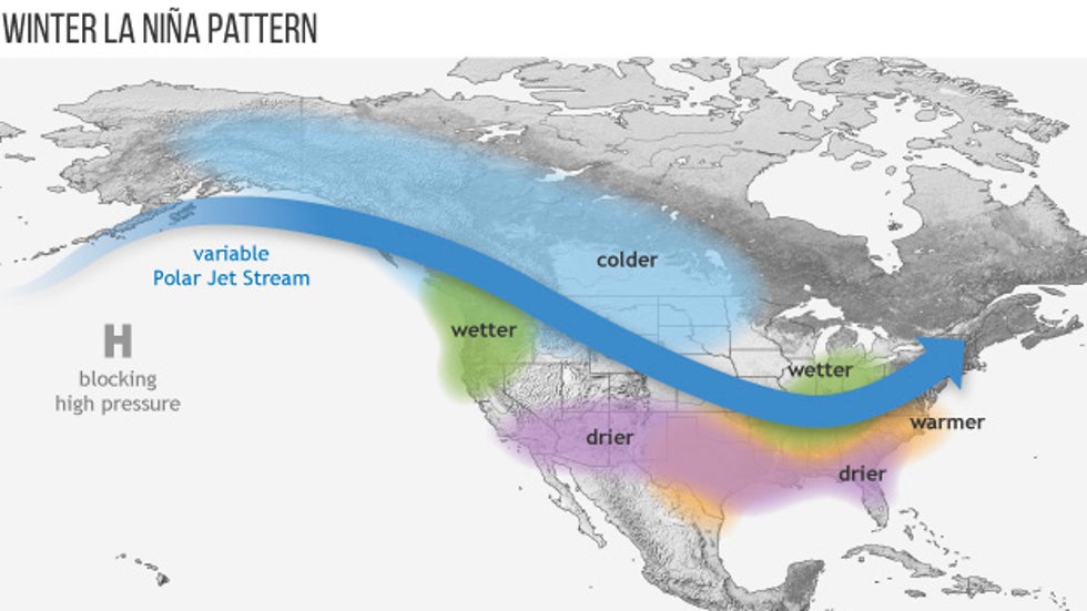
If La Niña develops, it could have some impacts on temperature and precipitation patterns in the U.S. this winter. But it's important to note that no single La Niña produces the exact same outcome as what has historically happened.
La Niña, El Niño or the lack of either, known as the neutral phase, is only one large-scale forcing on the atmosphere. It is not the sole factor in determining whether a season is wet, dry, cold or warm. Other atmospheric influences are in play, including atmospheric blocking.
Nevertheless, there are some general themes to expect in a La Niña winter, according to NOAA:
Southern U.S.: Above-average temperatures and below-average precipitation.
Northern U.S.: Below-average temperatures (particularly northern Plains and Northwest) and above-average precipitation.
"Typical La Niña winters see atmospheric ridging near the Aleutians, which helps to drive Arctic air into Canada. The wild card is whether there will be enough atmospheric blocking at high latitudes to push the colder air masses down into the U.S. If not, La Niña winters can be unusually mild," Crawford said.

While odds are tilted toward La Niña's development later this year, it's not yet a guarantee. NOAA will continue to monitor conditions in the equatorial Pacific Ocean for changes in the weeks and months ahead and provide updates.
The Weather Company’s primary journalistic mission is to report on breaking weather news, the environment and the importance of science to our lives. This story does not necessarily represent the position of our parent company, IBM.
The Weather Company’s primary journalistic mission is to report on breaking weather news, the environment and the importance of science to our lives. This story does not necessarily represent the position of our parent company, IBM.

No comments:
Post a Comment