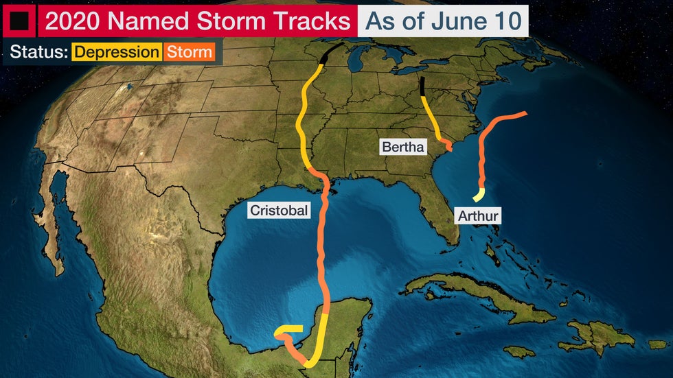
The 2020 Atlantic hurricane season is off to a fast start with three named storms by early June.
There have been several unusual aspects about this early-season activity. Below is a look back at some of the notables.
1. Cristobal's Remnants Head to Wisconsin
The most recent addition to the list of unusual occurrences is Cristobal's trek into Wisconsin.
Before Cristobal, the remnants of just three other Atlantic tropical cyclones had tracked through the state or its adjacent Lake Michigan waters in more than 100 years of records. The other three remnant systems were Gilbert in 1988, an unnamed former hurricane in 1949 and the former Galveston Hurricane from 1900.
Cristobal was different from those systems because its remnant traversed the entire length of the state to the Upper Peninsula of Michigan border. That's the farthest west on record a tropical cyclone remnant from the Atlantic has tracked through the Badger State.

2. Record-Earliest Third Named Storm
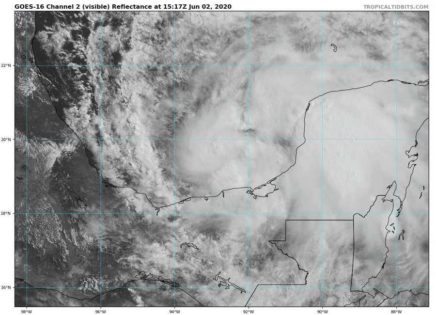
When Tropical Depression Three strengthened into Tropical Storm Cristobal on June 2, it marked the earliest the Atlantic has seen the "C" storm arrive.
The previous record was held by Tropical Storm Colin in 2016, which formed on June 5.
#Cristobal has formed in the Bay of Campeche - the 3rd Atlantic named storm of the 2020 season. This is the earliest date for an Atlantic 3rd named storm formation on record (since 1851). Old record was Colin on June 5, 2016.

3. A Duo of May Storms
Arthur and Bertha were the first two named Atlantic storms of 2020, and they both formed in May.
June 1 is the official start of hurricane season, but occasionally, storms form earlier than that date.
Arthur formed well east of Florida on May 16, and Bertha developed near the South Carolina coast on May 27.
There are only four other years in the Atlantic dating to 1851 where two storms have reached tropical storm intensity before May 27. That last happened in 2012, followed by 1951, 1908 and 1887, according Dr. Phil Klotzbach, a tropical scientist at Colorado State University.
4. Bertha's Last-Second Formation
Bertha was unusual because it formed just before making landfall in South Carolina.
It developed at 8:30 a.m. EDT on May 27, 30 miles east-southeast of Charleston, South Carolina. An hour later, the National Hurricane Center declared that Bertha had made landfall just east of Charleston with maximum sustained winds of 50 mph.
Bertha spread rainfall and gusty winds inland through the Carolinas into Virginia.
The disturbance that became Bertha brought more than a foot of rain to Miami. That rainfall cause widespread street flooding in parts of South Florida.

5. All Three Storms Have Impacted the U.S.
Arthur brought rainfall and gusty winds to North Carolina's Outer Banks, but never officially made landfall as it skirted Cape Hatteras on the way out to sea.
Bertha and Cristobal both made a U.S. landfall. Cristobal was the earliest in the year the continental U.S. has had its second landfall of the season, beating the previous record set on June 16, 2015 (Ana and Bill), according to Klotzbach.
Cristobal had the most widespread impacts of the three storms.
It brought locally heavy rain from Florida westward to Louisiana, and then northward through the lower Mississippi Valley and parts of the Midwest. Cristobal also inundated parts of the northern Gulf Coast with storm-surge flooding, particularly from southeast Louisiana to coastal Mississippi.
What Does the Unusual Start Mean For the Rest of Hurricane Season?
A busy start to hurricane season doesn't always guarantee conditions will remain that way.
"Historically, Atlantic tropical cyclone activity (as measured by Accumulated Cyclone Energy) through June 30th has had very little relationship with the remainder of the season's hurricane activity," said Klotzbach in a tweet on June 8.
But forecasters predict that oceanic and atmospheric conditions in the Atlantic will be favorable for a more active than usual hurricane season in the months ahead.
It's impossible to know for certain if a U.S. hurricane strike will occur this season. Keep in mind that even a weak tropical storm hitting the U.S. can cause major impacts, particularly if it moves slowly and triggers flooding rainfall. That's why residents of the Gulf and Atlantic coasts should be prepared each year no matter how active a hurricane season is predicted to be.
The Weather Company’s primary journalistic mission is to report on breaking weather news, the environment and the importance of science to our lives. This story does not necessarily represent the position of our parent company, IBM.
The Weather Company’s primary journalistic mission is to report on breaking weather news, the environment and the importance of science to our lives. This story does not necessarily represent the position of our parent company, IBM.


No comments:
Post a Comment