A slow-moving storm could bring flooding rainfall from the Great Lakes and Ohio Valley into the Southeast this week, while also contributing to rough surf and coastal flooding along parts of the East Coast.
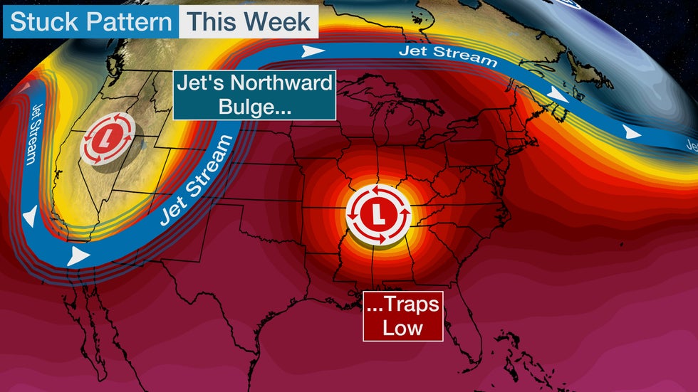
The jet stream will bulge so far north in the central and eastern U.S. that it will leave behind a swirling low in the East – what meteorologists call a "cutoff low." That swirling low is essentially cut off from the jet stream that would steer it away quickly.
 The upper-level wind pattern expected over the U.S. this week, including the sharp central ridge of high pressure and the eastern cutoff low.
This low will slowly pivot from the Ohio Valley and mid-South into the East in the week ahead. That means there will be several days of showers and storms from the Great Lakes and Ohio Valley into the Southeast and parts of the mid-Atlantic.
Coastal flooding, high surf and gusty winds could also impact parts of the East Coast because of this weather pattern.
Flood Threat From Days of Rain
This stalling weather system is already bringing showers and thunderstorms from the Great Lakes and Ohio Valley into parts of the South. Portions of these regions will have more rounds of rain in the coming days.
Street flooding and water rescues were reported across Chicagoland on Sunday afternoon and evening due to repeated rounds of heavy rain. Some roads had to be closed because of the flooding.
 Current Radar, Watches and Warnings
Forecast guidance is suggesting that an inch or more of rain could fall through Friday from Michigan and the upper Ohio Valley into the Southeast and southern mid-Atlantic. Some areas from the upper Ohio Valley to southwest Virginia, western North Carolina, upstate South Carolina and far northeast Georgia could receive more than 3 inches of rainfall.
Mountain and foothill areas of the southern Appalachians could have the highest totals of over 5 inches. That's because rainfall will be enhanced in these areas from moist southeast or east winds gliding up the higher terrain.
(MAPS: 7-Day U.S. Rain Forecast)
 Rainfall Forecast
Flash flooding and river flooding could occur because of this multiday rain event. Here's a general look at where there could be at least localized flooding in the next few days.
-Monday-Monday Night: Lower Michigan to the upper Ohio Valley and southern Appalachians.
-Tuesday-Tuesday Night: Northern South Carolina and North Carolina into northeast Georgia, southwestern Virginia and the upper Ohio Valley.
-Wednesday-Wednesday Night: From southwest Virginia to much of North Carolina, northern South Carolina and northeast Georgia.
Flood watches have been issued by the National Weather Service from portions of the Great Lakes into the upper Ohio Valley. Additional flood watches for this storm system could be issued in the week ahead.
 Flood Alerts
Coastal Concerns
Tropical Storm Arthur will churn up rough surf and create dangerous rip currents early this week on the Southeast and mid-Atlantic coasts.
By Tuesday or Wednesday, a combination of lower pressure in the East and higher pressure over southeastern Canada or northern New England will drive persistent, strong easterly winds between those pressure features.
These onshore winds could produce high surf, rip currents and coastal flooding, particularly where the winds last the longest.
It's too early to be certain on the details this far out, but coastal areas from North Carolina to the mid-Atlantic Seaboard could be most impacted.
Check back to weather.com for updates in the week ahead.
 Coastal Concerns
The Weather Company’s primary journalistic mission is to report on breaking weather news, the environment and the importance of science to our lives. This story does not necessarily represent the position of our parent company, IBM.
The Weather Company’s primary journalistic mission is to report on breaking weather news, the environment and the importance of science to our lives. This story does not necessarily represent the position of our parent company, IBM.

No comments:
Post a Comment