 Emma Pritchett, 78, holds up a broken glass from her kitchen sink the day after a tornado hit on Monday, April 13, 2020, in Chatsworth, Georgia.
After a hyperactive start to the typical peak of severe weather, including the deadly Easter tornado outbreak in April, the busiest month for tornadoes has been unusually quiet.
Noting that there is more than a week left in May, the count for preliminary tornadoes from NOAA's Storm Prediction Center is 351 in April and just 47 in May so far, through May 20.
(MORE: April 2020 Among the Busiest Tornado Months in History)
This is largely because of a pair of unfavorable large-scale patterns that have persisted in the first three weeks of May.
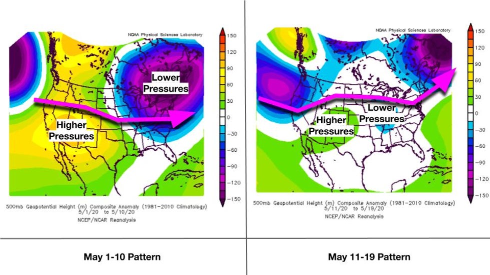
The first was anchored by a warm West Coast and a downright cold Northeast, which brought the jet stream northward over the Rockies, then southward in a dip into the mid-South. This eastward or east-southeastward flow of the jet stream across the country is unfavorable for tornadoes.
The second included a flip toward a much more northward jet stream over much of the country and an upper level low over much of the East. The upper-level low-pressure system brought cooler conditions and winds from the north that eliminated any chance of tornado formation for much of mid-May.
This northward bulge in the jet stream north of tornado alley also removed all energy and wind shear, which is needed for tornadogenesis, from the region.
 Pressure and temperature patterns compared to average in the first part of May 2020 (left) and mid-May 2020 (right). The arrow shows where the jet stream was.
This is a major contrast to what happened last year.
A tornado sequence consisting of three separate outbreaks lasting for two weeks spawned nearly 400 tornadoes in the central and northeastern U.S., including two EF4 tornadoes that hit Dayton, Ohio, and Linwood, Kansas.
The onslaught killed eight people and caused about $7 billion in damage.
May 2020 has been a distinct change from that, and it doesn't seem like that's going to change in the end of the month.
As of Thursday, there are no large severe weather outbreaks anticipated by NOAA's Storm Prediction Center through the next week.
The large number of tornadoes in April of this year is actually closer to what we typically see in May. Typically, May (276 tornadoes) has about one and a half to two times the number of tornadoes as April (155).
While we’re celebrating a slow tornado month this May, it is a rare occurrence.
From 1980-2019, only five Aprils have been more active than the May that followed, and only two Aprils have been twice as active as May of that same year. Three years had similar tornado counts in April and May.
May is typically the most active month for tornadoes because it is when the best ingredients for the birth of tornadoes come together in the largest supply.
That is, active months are most likely:
- When moisture from the Gulf of Mexico is drawn northward most successfully by strong low-pressure systems
- When afternoons heat into the 70s, 80s and 90s for great vertical cloud development
- When the jet stream is still strong enough and located over the country’s midsection to cause strong wind shear over the Plains and South
We looked at monthly averages to see if there are differences in large-scale weather patterns that likely contribute to active tornado months.
Here, we defined active Aprils as any April that had more tornadoes than May, and an active May as any May that had at least three times as many tornadoes as April of the same year.
These graphics do not show severe weather events, but rather climate patterns on the scale of a month that could be supportive of more tornadoes. For example, these graphics show months that had multiple days or weeks of tornadoes, but they won’t show any storm systems that led to singular big outbreaks.
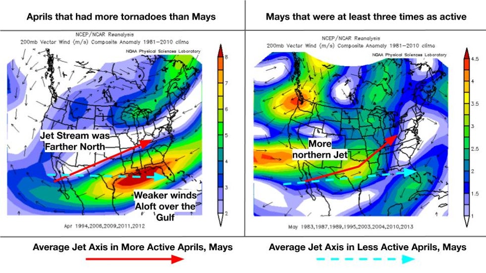
A common trait of active months is that the jet stream is located over the Plains and the Ohio and Tennessee valleys, shown in red arrows on the graphic below. The inactive months had a jet stream over the northern Gulf of Mexico (in cyan).
The graphic shows the anomalous wind speed at jet stream level for active Aprils (left) and Mays (right).
In April, the jet steam was farther north completely – closer to the usual May position. This is shown by the east-to-west anomalous winds over the Gulf, but shows up well in actual wind data (not shown, but demarcated by the cyan arrow).
 Wind speeds at 35,000 to 40,000 feet compared to average in April (left) and May (right) for the most active Aprils and Mays.
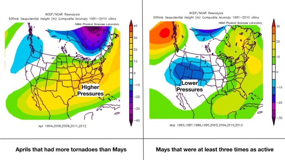
In May, a stronger jet stream is needed over the Plains and Midwest for an active tornado month. A stronger dip in the jet stream over the West also seems to increase tornado months, as seen by the stronger winds in the Eastern Pacific and in the lower pressures in the second graphic below.
One other thing that impacts how many tornadoes form during a month is the prevailing pressure pattern.
It seems that the most active Aprils also have slow-moving storm systems that are possibly slowed by higher pressures over the Southeast, in Dixie Alley, which is where many tornadoes occur during April. Slower storm systems that can feed on favorable ingredients for severe weather for several days before plowing off the East Coast can produce more tornadoes.
This is also somewhat present in active Mays, but a stronger low-pressure system or trough over the West is even more supportive. Strong low-pressure systems that roll east off the Rockies can spin up faster, providing more northward pull for heat and humidity, and more wind shear for thunderstorms to use to produce tornadoes.
 Pressure and temperature patterns compared to average in April (left) and May (right) for the most active Aprils and Mays.
The Weather Company’s primary journalistic mission is to report on breaking weather news, the environment and the importance of science to our lives. This story does not necessarily represent the position of our parent company, IBM.
The Weather Company’s primary journalistic mission is to report on breaking weather news, the environment and the importance of science to our lives. This story does not necessarily represent the position of our parent company, IBM.

No comments:
Post a Comment