Published: April 2, 2020
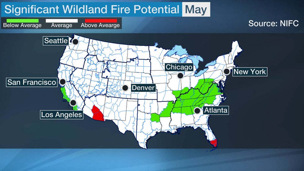 Areas in red have an above-average risk of significant wildland fire, while areas in green have a below-average risk for June.
A wet pattern has prevailed across much of the southern and eastern United States so far this year, but drier-than-average conditions may lead to above-average wildfire potential in Florida late this spring and in parts of the West this summer.
The U.S. can expect average to below-average wildfire potential in April, according to the National Interagency Fire Center (NIFC) outlook released on April 1.
(MORE: April Temperature Outlook)
However, the wildland fire potential will increase to above average in South Florida and southeastern Arizona in May. Much of Florida has experienced drier-than-average conditions so far this year, especially in March. Miami had its second-driest March on record with only 0.10 inches of rain. Dry conditions are expected to continue into at least mid-spring in Florida, which will raise the fire concern there until precipitation increases by late spring or early summer.
Summer Wildfire Potential
Above-average wildfire threat will expand in parts of the West into midsummer, although below-average wildfire potential is anticipated along coastal Southern and Central California.
Into June
Southeastern Arizona will have above-average wildfire threat May into June. The NIFC noted that fine fuels (grass, leaves, needles, etc.) suggest an above-average wildfire potential until the monsoon arrives in July for the desert regions of southern Arizona.
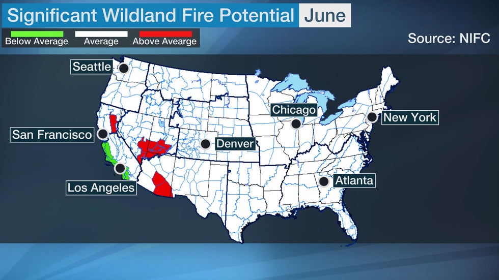 Areas in red have an above-average risk of significant wildland fire, while areas in green have a below-average risk for June.
Much of the Great Basin has had generally dry conditions since last summer, and moderate to severe drought conditions exist in parts of Nevada and Utah.
Near to above-average precipitation is forecast in this area for April, according to NOAA's Climate Prediction Center, which is good news, but a significant drying and warming period is expected from May into early summer, according to NIFC's outlook. This raises the fire concern there beginning in June.
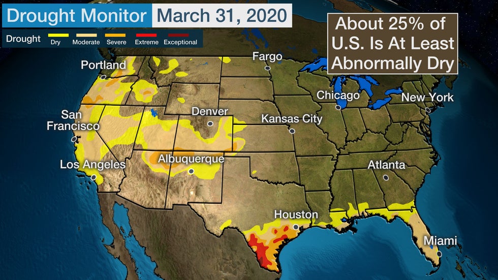 Abnormally dry and drought conditions as of March, 31, 2020.
Into July
The wildfire risk increases in June in parts of Northern California and expands across more of the northern part of the state into July.
Precipitation was above average in March for much of Northern California, but it was not enough to make up for the record-dry February. Seasonal precipitation and the mountain snowpack are roughly half of average for April 1, the NIFC outlook said.
The wet pattern in Northern California is expected to end in early April, allowing drier and warmer conditions to return and continue into the summer. The snowpack is projected to melt by early June, a full month earlier than usual. The outlook also predicts the area will dry out
"The first precipitation of the 2019-20 rainy season had very low snow levels, so dry fuels and soils can be found under the blanket of snowpack. This means that there will be even less beneficial runoff in the late spring and early summer, and this will lead to an earlier date of critical fuel dryness at middle and high elevations," the authors said.
However, in some areas of Northern California, new fires may be easier to control compared to the last few years due to above-average annual grass crops.
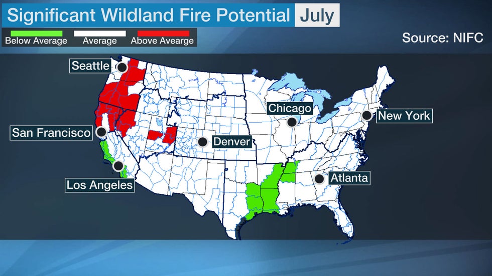 Areas in red have an above-average risk of significant wildland fire, while areas in green have a below-average risk for July.
Much of the Pacific Northwest will also experience above-average fire potential in July.
Unlike the Sierra Nevada mountains in California, which are well below average in terms of snowpack, Washington and northwestern Oregon have generally had near or above-average snowfall this season.
However, by May, a warmer and drier pattern is expected to emerge and will continue into the summer. This will worsen conditions where moisture levels are already low, especially in southern Oregon, where snowfall has recently decreased.
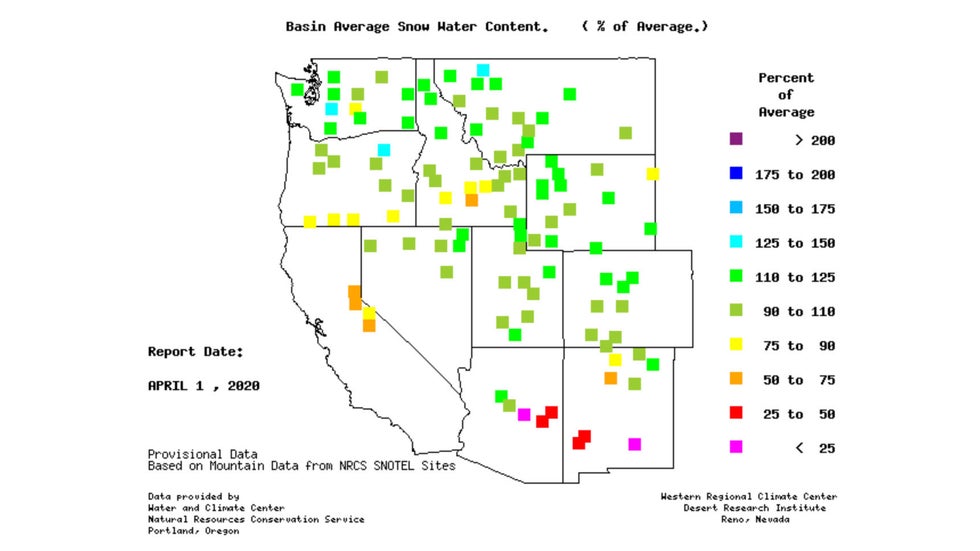 Snow-water content compared to average as of April 1, 2020.
The news is better for Southern California, where near or below-average wildfire potential is expected through July. A deeper marine layer compared to average is likely this spring along the Central and Southern California coast.
Monsoonal thunderstorm activity is also expected to be below average this summer due to the upper-level ridge of high pressure being centered farther south and east than average. This will lower the risk of lightning-caused fires.
Average or below-average wildland fire potential is anticipated this spring into early summer in areas east of the Rockies.
Soil moisture is well above average from the Plains to the East Coast, and several locations in the Deep South have had one of the wettest starts to the year on record. This includes Jackson, Mississippi, which saw its wettest January through March on record with 28.29 inches of precipitation.
The wet pattern will likely persist in parts of the South and East into at least early summer. As a result, the wildfire risk is generally lower, and fire season will likely begin later than average.
The Weather Company’s primary journalistic mission is to report on breaking weather news, the environment and the importance of science to our lives. This story does not necessarily represent the position of our parent company, IBM.
The Weather Company’s primary journalistic mission is to report on breaking weather news, the environment and the importance of science to our lives. This story does not necessarily represent the position of our parent company, IBM.

No comments:
Post a Comment