Published: March 2, 2020
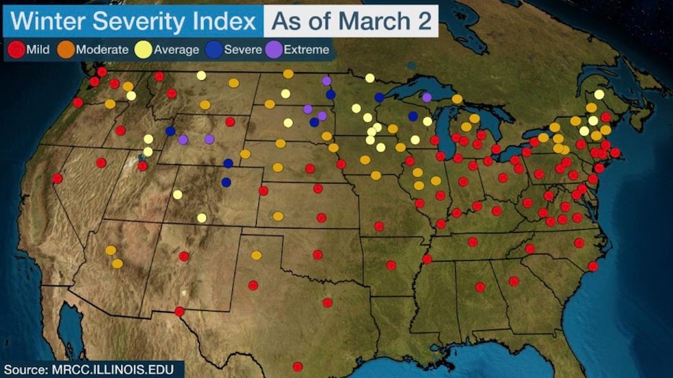 Accumulated Winter Season Severity Index values for 2019-20 as of March 2. AWSSI calculations start on Dec. 1, or sooner if there is measurable snow or a daily high temperature below freezing. The AWSSI winter season extends beyond February if either of those events occur or if there is at least 1 inch of snow still on the ground.
Meteorological winter is defined by the three coldest months of the year for most of the United States: December, January and February. The 2019-20 winter has gone down in the books as a mild one for most. It is always fascinating to see how winter impacts compare across various cities in our nation, but how can we define the impacts of winter on a level playing field for everyone?
The answer is the Accumulated Winter Season Severity Index (AWSSI).
This novel approach to assessing winter impacts uses three parameters that most people would agree help them judge just how impactful the winter season was. They are the intensity and persistence of cold weather, the total amount of snowfall and the amount and persistence of snow on the ground.
AWSSI was developed to objectively quantify and describe the relative severity of the winter season using those factors that we are all too familiar with.
One look at the map above confirms what many people have been talking about across much of the U.S.: it has been a mild winter, and that has meant much less snow for many locations.
The only regions where at least some locations experienced a more severe winter than usual are parts of the Rockies, Northern Plains and upper Midwest.
Jet Stream Keeping Winter Storms to the North
One of the main reasons for the pattern of winter severity shown on the map is the polar jet stream, which defines the overall large-scale weather pattern for the nation. This ribbon of fast-moving air that encircles the Earth not only separates the really cold weather to its north from milder weather to its south, it also is essentially the "racetrack" that surface weather systems follow as they traverse the U.S.
For much of this year, the jet stream has been locked in a pattern of a large-scale trough in the West and a ridge in the East. Not only has cold air been almost nonexistent in the East, but very few winter storms have tracked through the region, with the exception of northern New England, where there has been enough cold air to produce snow.
In fact, you would be hard-pressed to find one significant Northeast snowstorm this winter.
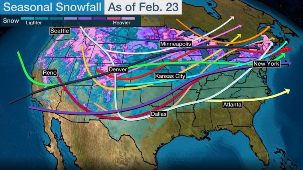 Tracks of the named winter storms through Feb. 23, 2020, overlaid onto the seasonal snowfall. Note that the only areas that had received significant snow were the Rockies, upper Midwest and far northern New England.
Above is the track of the winter storms named by the Weather Channel in 2019-20 through late February. As you can see, the storm tracks have tended to move from the Rockies northeastward toward the Great Lakes. The heaviest snowfall typically occurs to the north and west of those tracks, and it is no coincidence that those tracks and snowfall match up very well with the only portion of the U.S. that has experienced a real winter.
Let’s take a look at some of the underachievers, as well as those few who have overachieved during this past winter season. The AWSSI charts below are calibrated against the long-term average conditions at each location in the U.S. to make the playing field equal.
The researchers examined all of the winter information since 1950 to set each city's own high- and low-end bars. So a severe winter in Atlanta will have a much different definition in terms of actual temperatures and snowfall than say, one in Caribou, Maine – but from a local standpoint, that winter is still severe to the residents of Atlanta compared to what they normally see.
Our first location is New York City, where the average temperature during the December-through-February timeframe was more than 4 degrees above average. Match that with a seasonal snowfall of 4.8 inches (16.7 inches below average) and you’re talking a very mild winter, as shown in the chart below.
 AWSSI values for New York (Central Park) for winter 2019-20 through February. The combination of very warm temperatures and very little snowfall made New York's
winter of 2019-20 one of the least severe on record by AWSSI standards.
Farther to the west, Chicago was a bit closer to the average tracks of several winter storms, so they received several minor bouts of snow but no significant snowstorms. In fact, its highest daily snowfall occurred way back on Oct. 31 and Nov. 11, 2019, when 3.4 inches fell each day.
Otherwise, Chicago was “nickeled and dimed” with its daily snowfall, amounting to a seasonal snowfall total thus far of 26.9 inches, about 3 inches below average.
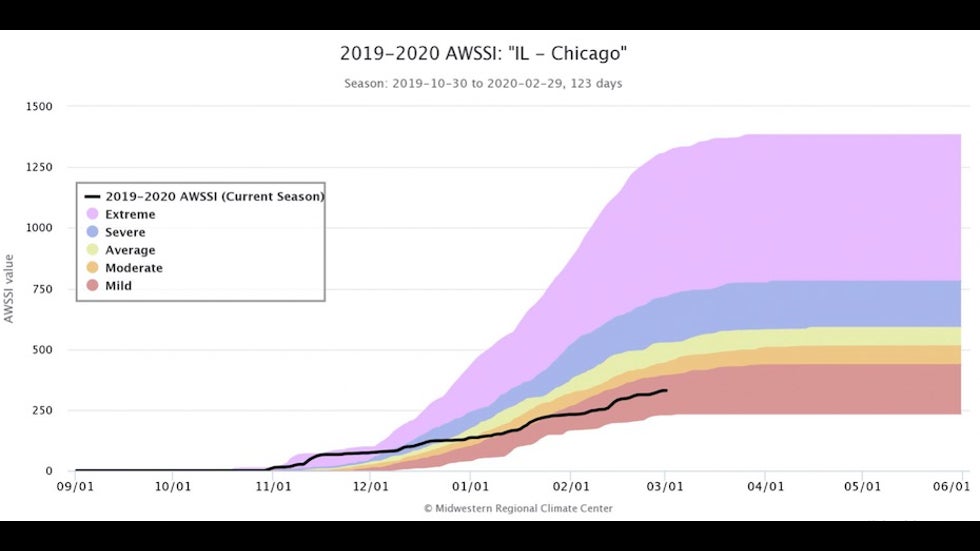 AWSSI values for Chicago for winter 2019-20 through February.
The bigger factor making this winter less severe than usual was temperature, with the average running about 5 degrees warmer than usual. That, combined with meager daily snowfall, meant much less daily snow cover through the season. As a result, Chicago got away with a mild winter overall, as shown above.
You had to go west to the Rockies to get an "in-your-face" winter in places like Denver. There were several significant snowfall events in that part of the country this winter. In fact, the ski areas have been doing exceptionally well. Couple that with winter temperatures averaging about 1 degree below average and it equates to a "severe" ranking on the AWSSI chart.
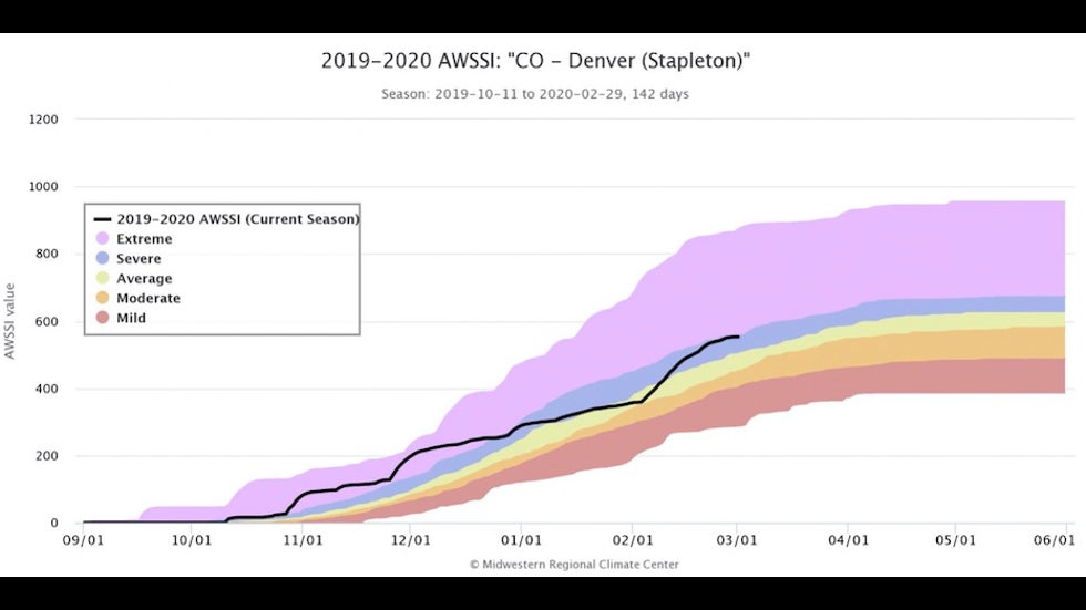 AWSSI values for Denver (calculated at the former site of Stapleton International Airport) for winter 2019-20 through February.
By the way, Denver, your winter is not over by any means. In fact, your snowiest month on average is March.
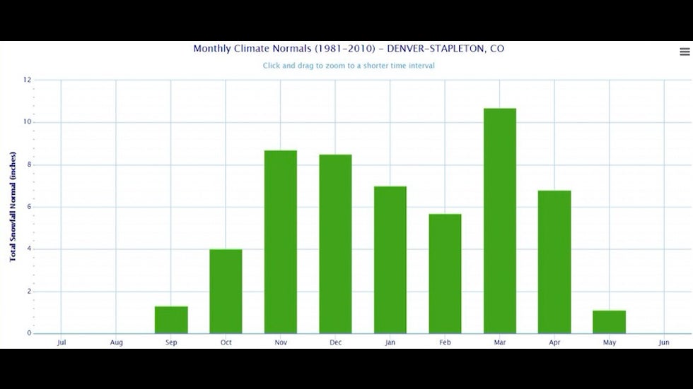 Monthly snowfall in Denver, Colorado (Stapleton) for the period 1981-2010. (NWS)
If you would like to check out your city in more detail, see the AWSSI website maintained by the Midwest Regional Climate Center.
The Weather Company’s primary journalistic mission is to report on breaking weather news, the environment and the importance of science to our lives. This story does not necessarily represent the position of our parent company, IBM.
The Weather Company’s primary journalistic mission is to report on breaking weather news, the environment


No comments:
Post a Comment