WINTER WEATHER Updated Feb. 28, 2020 2:18 PM
The end of a brief stretch of record heat will not come with any meaningful rainfall across California this weekend, as the state continues its need for a thorough soaking.
In what has been a lackluster wet season, this month is set to become the driest February on record in several locales, including Redding, Sacramento and Ukiah.
The latest outlook from the United States Drought Monitor shows that abnormally dry to moderate drought conditions are affecting close to 6 million California residents. This is up from around 1.35 million residents just last week.
"It's likely that San Francisco will indeed end the month with no rain, which has not happened in February since the 1860s," AccuWeather Senior Meteorologist and western U.S. blogger Brian Thompson said.

"It is quite remarkable to have places like Santa Rosa and Ukiah, which average over 6 inches of rain for the month, come up dry," he added.
This unprecedented dryness during February is likely to become reality in these cities with rain-free conditions expected through Saturday.
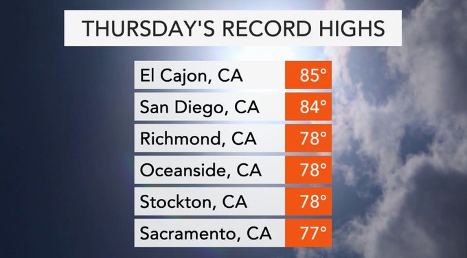
Temperatures will soar to record-challenging levels again on Friday, following a number of new records being set on Thursday.
The record heat will end as a storm system dives southward across the state this weekend, dragging in colder air with it.
Unfortunately, very little moisture associated with the storm will be wrung out in the form of rainfall.
"For those in California looking to cash in on some more rain before the wet season winds down, the prospects are not looking good," Thompson said.

No more than a spotty shower or two is expected around California's Central Valley, San Diego and the L.A. Basin on Sunday. No more than 0.10-0.20 of an inch of rain may fall in these areas.
Given the magnitude of the cold air aloft, thunder, lightning and small hail are possible in any robust showers.
The cold storm is likely to pack more of a punch across the higher terrain, with heavy snow and wintry travel expected.
Around a foot of snow could fall on the highest peaks of the Sierra Nevada mountains. Travelers over Interstate 80's Donner Pass are likely to face snow clogged roadways from Saturday night through Sunday.
RELATED:
Farther south, snow levels are likely to dip low enough to create slippery travel and possible delays along I-5 at Tejon Pass to end the weekend.
While snow may initially melt on roadways given how mild it has been, slippery conditions can quickly develop as temperatures plummet and the pavement cools. The greatest likelihood of such conditions are Sunday night into Monday morning across the Southern California mountains.
Gusty winds can add another layer of travel difficulties for portions of interstates 10, 15, and 40 across eastern portions of Southern California and the balance of the Southwest Sunday into Monday.
As the storm spreads rain and high-elevation snow showers across the Four Corners states early next week, drier weather will return to California.
Correction: This story previously said Interstate 90 went through Donner Pass. It has been corrected to Interstate 80.
Keep checking back on AccuWeather.com and stay tuned to the AccuWeather Network on DirecTV, Frontier and Verizon Fios.


No comments:
Post a Comment