WINTER WEATHER Updated Jan. 18, 2020 5:00 AM
In the wake of a storm system that brought the first snowfall of the season to places like Seattle and Portland, yet another disturbance will take aim at the region early this weekend.
So far this short year, both Portland and Seattle have observed measurable precipitation each day of 2020. The upcoming forecast looks to continue this trend.

This image, taken during Friday midday, Jan. 17, 2020, shows a new storm approaching the Northwest coast of the United States. (NOAA / GOES-West)
As the storm system approaches, snow levels will gradually rise between 1,500 and 2,000 feet, bringing an end to the threat for accumulating snow across the valleys. While precipitation will not be widespread in nature, an occasional snow shower or two can still be expected across the higher terrain.
Following spotty showers from the daytime on Friday across the lowlands, a steadier rain spread across the region late Friday night.

As the storm continues to impact the region, increasingly windy conditions will persist Saturday, especially along the coast.
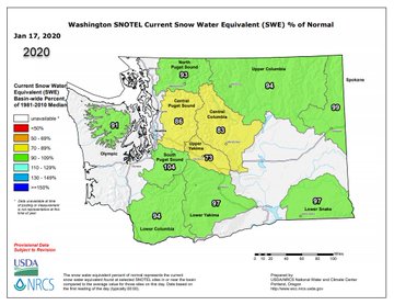
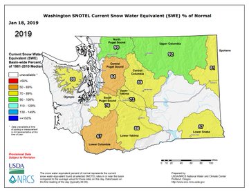
Heavy snow is expected across both the Cascades and the Olympic Mountains Saturday. The persistent stormy pattern has resulted in a beneficial snowpack across the Cascades this winter season, with snow water equivalent values now surpassing levels observed at this time last year.
With all of the recent storm systems to impact the region, the avalanche threat will become increasingly high. Although snowfall isn't expected across the northern Sierra from this storm system, an elevated avalanche risk will be in place as well.
Fluctuating snow levels and varying precipitation types have led to the conducive conditions for avalanches. An employee at the Sierra Avalanche Center explains what has led to the heightened avalanche threat via this short Twitter video.
One person was killed and another person was seriously injured by an avalanche at Alpine Meadows Ski Resort, California, during Friday midday, according to the Placer County Sheriff Office.
For those heading out to the ski resorts this weekend, it may be wise to avoid some back-country trails to avoid the avalanche threat.
With the exception of a few showers across the coastal Pacific Northwest, much of the northwestern United States can expect to have dry and settled conditions Sunday and Monday as a ridge of high pressure briefly builds.
RELATED:
Quiet conditions will be short-lived, however, since yet another storm system will track into the West Coast by Tuesday.
The exact track will play a determining factor as to how low the snow levels will fall Tuesday and Wednesday. At this time, it is likely that at least some of the Northwest passes will receive snowfall from next week's storm system.
Looking ahead, AccuWeather meteorologists continue to predict that the unsettled pattern across the Northwest will continue into the latter half of next week and the remainder of January.
Keep checking back on AccuWeather.com and stay tuned to the AccuWeather Network on DirecTV, Frontier and Verizon Fios.


No comments:
Post a Comment