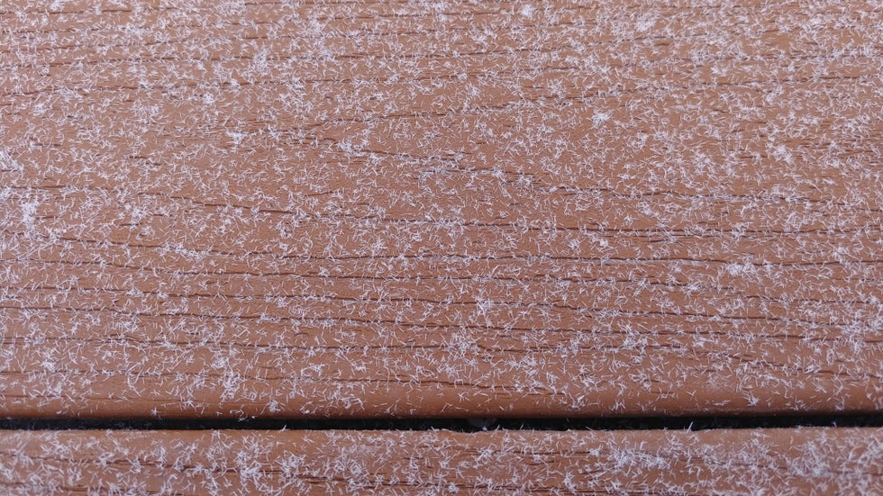
Snow fell in northern Utah early Wednesday, but it wasn't the typical one-of-a-kind geometric snowflake seen in the movies.
Instead, the snow fell in thin, short needles that resembled shedded dog hairs.
The big difference between Hollywood-cliche snowflakes and the snow that fell in Utah was the temperature of the air in which the flakes formed.
The needles developed close to the ground, in air that was slightly warmer than the layers higher up, where classic snowflakes usually form.
At the time, the town of Logan, Utah, was in a surface layer of air that was roughly 22 to 24 degrees – cold enough for snow to form, but not cold enough for the familiar flakes with six arms, known as dendrites.
In this narrow temperature range, tiny ice crystals cannot easily expand into the branches that make up dendrites due to unstable edges. Instead of growing wider, they lengthen.
As the crystals fall, moisture aggregates on the ends of the ice particles and freezes, which slowly elongates the crystals into needlelike structures.

In contrast, the more hexagonal or branched dendrites typically form higher in the atmosphere, in air that is 15 degrees or colder. They can also develop at temperatures just below freezing, when snow crystals may collide and congeal into especially large flakes.
Another factor of snow formation is how much time snow crystals spend in high-humidity air before hitting the ground. When moisture is plentiful, the crystals have more opportunity to grow larger and to branch out.
The Utah snow needles didn't form in typical clouds.
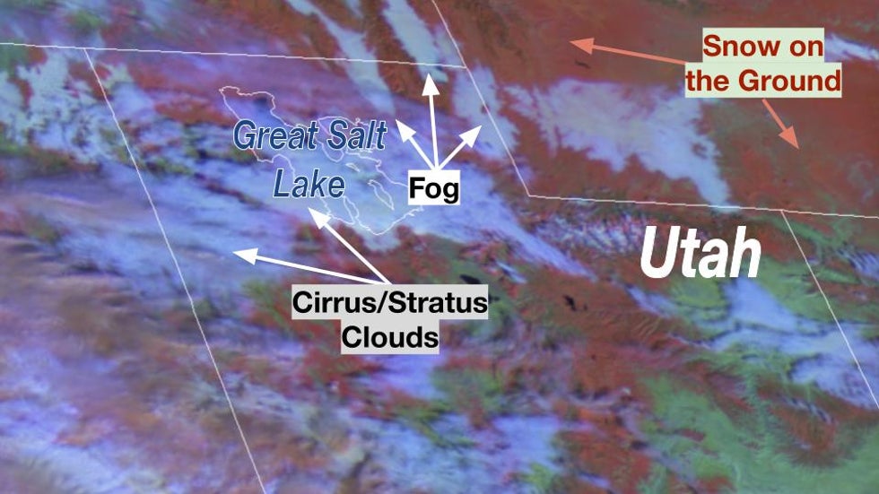
This snow fell out of a dense, shallow freezing fog that had lingered around northern Utah and adjacent portions of Wyoming and Idaho for more than 12 hours.

Both the fog and the snow developed as a thin layer of deep moisture got stuck under a bubble of sinking air aloft, known as an inversion.
The dense freezing fog provided just enough moisture for precipitation to develop – in this case, in the form of snow needles.
The ice particles didn't have enough time to grow into dendrites before hitting the ground because the moist layer was so shallow. The snowflakes also formed in the distinct temperature range that favors needle formation.
The freezing fog accumulated into frost on trees and other surfaces, creating quite the wintry scene. At times, visibility dropped as low as 100 feet.
Freezing fog occurs when below-freezing temperatures drop to near the dew point. Sinking air aloft and a lack of wind can make visibility close to zero.
The Weather Company’s primary journalistic mission is to report on breaking weather news, the environment and the importance of science to our lives. This story does not necessarily represent the position of our parent company, IBM.
The Weather Company’s primary journalistic mission is to report on breaking weather news, the environment and the importance of science to our lives. This story does not necessarily represent the position of our parent company, IBM.

No comments:
Post a Comment