Thursday, October 31, 2019
Southern Westchester Wind Advisory Wind Advisory in effect until Friday, 6:00 AM EDT. Source: U.S. National Weather Service
...WIND ADVISORY IN EFFECT FROM 8 PM THIS EVENING TO 6 AM EDT
FRIDAY...
* WHAT...South to Southwest winds 20 to 30 mph with gusts up to 50
mph.
* WHERE...In New Jersey, Hudson, Eastern Bergen, Eastern Essex
and Eastern Union Counties. In New York, Southern Westchester,
New York (Manhattan), Bronx and Richmond (Staten Island)
Counties.
* WHEN...Tonight.
* IMPACTS...Strong winds will bring down scattered limbs, trees,
and power lines. Scattered power outages are expected.
PRECAUTIONARY/PREPAREDNESS ACTIONS...
Use extra caution when driving, especially if operating a high
profile vehicle. Secure outdoor objects.
Westchester Severe Thunderstorm Watch Severe Thunderstorm Watch in effect until Friday, 1:00 AM EDT. Source: U.S. National Weather Service
NY
. NEW YORK COUNTIES INCLUDED ARE
ORANGE PUTNAM ROCKLAND
WESTCHESTER
Two New California Wildfires Burn Homes In San Bernardino, Riverside; Evacuations Underway
Ron Brackett and Jan Wesner ChildsPublished: October 31, 2019
 A firefighter passes a burning home as the Hillside Fire burns in San Bernardino, California, on Thursday, October 31, 2019. The blaze, which ignited during red flag fire danger warnings, destroyed multiple residences.
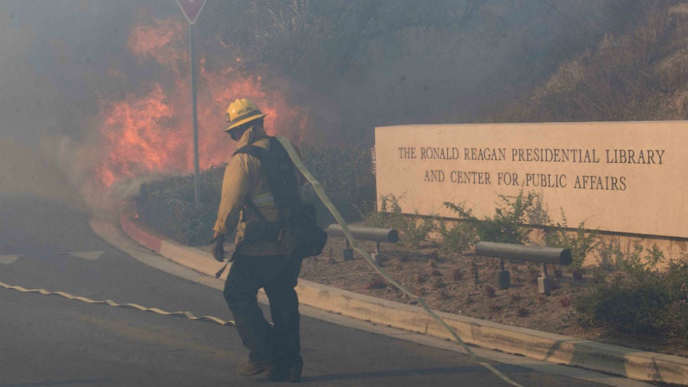 Firefighters battle to protect the Ronald Reagan Presidential Library from the Easy Fire in Simi Valley, California, on Oct. 30, 2019.
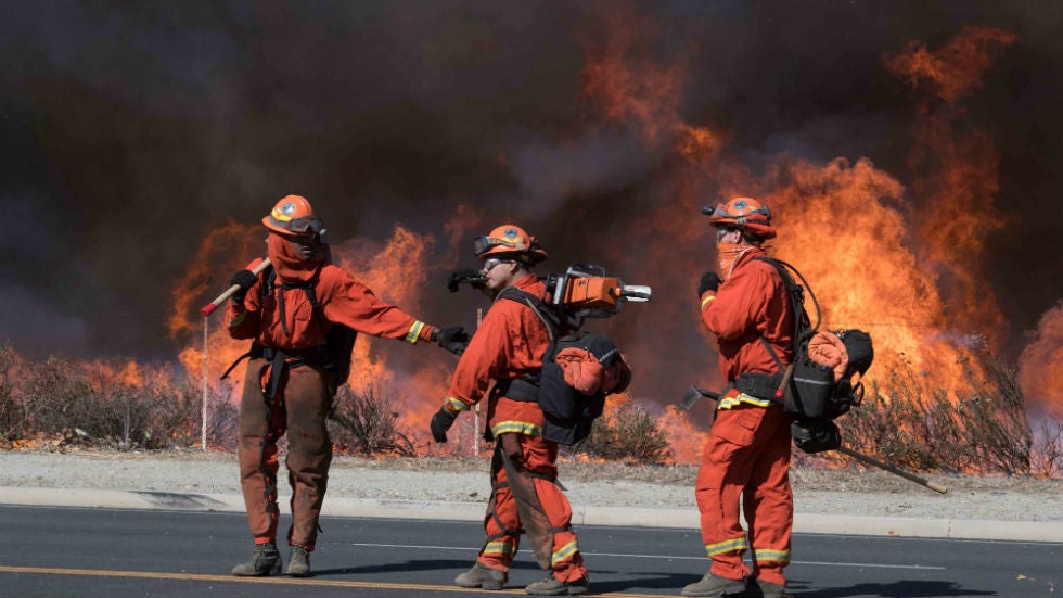 Firefighters prepare to put out flames on the road leading to the Ronald Reagan Presidential Library during the Easy Fire in Simi Valley, California, on Oct. 30, 2019.
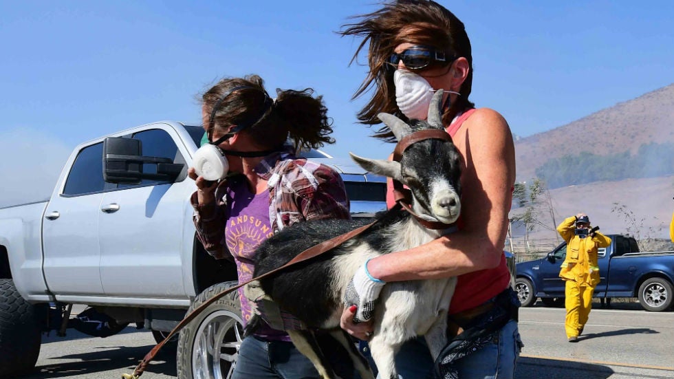 Laura Horvitz (R) and Robyn Phipps help rescue goats from a ranch near the Ronald Reagan Presidential Library in Simi Valley during the Easy Fire in Simi Valley, California, on Oct. 30, 2019.
Residents of north San Bernardino were forced to flee overnight when a fast-moving wildfire engulfed several homes as it raced through neighborhoods early Thursday.
Meanwhile, a second fire forced more evacuations in the Jurupa Valley near Riverside, California.
The Hillside Fire in San Bernardino had burned through 200 acres as of 4 a.m. local time, shutting down a stretch of Highway 18 as it burned out of control.
The San Bernardino County Fire Department said several of the burning structures were homes. Video taken by local media showed houses and other structures on fire.
The fire in the Jurupa Valley, east of Los Angeles in Riverside County, is being called the 46 Fire. It began about 12:30 a.m. Thursday and had burned 75 acres and was 0% contained as of about 2:45 a.m., according to Cal Fire Riverside.
Evacuations were ordered for residents south of Limonite Avenue, west of Crestmore, east of Van Buren and north of the Santa Ana Riverbottom.
The fire started near where the pursuit of a possible stolen vehicle ended, according to the Riverside County Sheriff’s Department. One person was in custody.
The 46 Fire was the second blaze to break out in the Jurupa Valley in less than 24 hours.
The first began Wednesday morning, and it also forced evacuations, including at a nursing home, where several patients in wheelchairs and stretchers were helped out by workers as thick plumes of smoke shot into the sky, KABC-TV reported. Groups of patients were seen wearing face masks, waiting for transportation near a roadway off-ramp.
The blaze was named the Hill Fire. Early Thursday, it had burned about 300 acres and was 15% contained, according to Cal Fire. One civilian had sustained minor injuries, and a house and mobile home were damaged.
Also on Wednesday, a fast-moving wildfire in Ventura County, California came dangerously close to the Ronald Reagan Presidential Library.
Nearby residents fled with whatever belongings they could carry and scrambled to get horses and other livestock out of harm's way.
Mandatory evacuations were ordered after the blaze, known as the Easy Fire, started just before 7 a.m. Wednesday and burned close to several neighborhoods in the Simi Valley. The fire burned more than 2 square miles within just a few hours. It was 5% contained Thursday morning
The Easy Fire was threatening 7,000 homes affecting 26,000 residents, officials said. Most of those were under the mandatory evacuation order.
"The fire outflanked us very rapidly today, pushed by those 40 to 45 mph winds," said Ventura County Fire Department Assistant Chief Chad Cook, adding that gusts reached 60 mph and aerial operations had to be grounded at times.
Several outbuildings had burned and there were reports of at least one home in flames.
The cause of the fire was under investigation, but Southern California Edison filed a report with state regulators that said it began near power lines owned by the utility, the Associated Press reported.
Melissa Giller, spokeswoman for the Reagan library, said flames started coming up the back part of the museum property about 9 a.m. Wednesday.
Giller described the harrowing scene to The Weather Channel late Wednesday morning.
"It got to about, within about 50 feet, of the Reagan library, to the outskirts. The firefighters threw water drops and on-ground firefighters were able to turn the fire around. But now, from what I’m seeing on the news and what I’m hearing is now the fire coming up the front side, the complete opposite of our property," Giller said.
A handful of employees were onsite monitoring the situation.
"They said that even though the fire is sort of circling the library, they still feel completely safe," Giller said. "The amount of water drops that the fire department is doing … they are dropping so much water that the museum building itself and all of our buildings are completely safe."
More than a million people remained without electricity Wednesday morning due to precautionary shutoffs aimed to prevent wildfires. Pacific Gas and Electric started shutting off power Tuesday to some 540,000 customers in parts of 27 counties, the utility said in a press release. Southern California Edison had cut electricity to about 40,000 customers and was warning another 300,000 could lose power.
All told, estimates say the outages affect more than 1.5 million people when taking into account household size and other factors.
"One of the things that gives us the most concern with this particular kind of weather is debris flying into equipment," Robert Villegas, a Southern California Edison spokesman, told The Weather Channel.
Villegas said most of the affected Southern California customers were in Ventura County where the Easy Fire was burning.
Getty Fire
The Getty Fire began on the west side of the 405 freeway near the Getty Center about 1:30 a.m. Monday, according to the Los Angeles Fire Department. In a Tuesday afternoon press conference, Los Angeles mayor Eric Garcetti said the blaze was started when a tree branch was blown onto a power line by strong winds. The incident was captured on dashcam footage.
By Wednesday, it had spread to just over 1 square mile and threatened more than 7,000 structures. It was almost 40% contained. Most evacuation orders were lifted for all but a small area next to the 405.
Twelve homes were destroyed in the fire and another five were damaged. More than 700 firefighters were on the scene.
Kincade Fire
In Northern California, firefighters appeared to be making headway on the Kincade Fire, which had burned nearly 120 square miles and was 45% contained as of Wednesday night. The fire, which started on Oct. 23 near Geyserville, has destroyed at least 266 structures, including 133 homes.
More than 90,000 structures were threatened and 126,000 people were under evacuation orders, although many were allowed to return home Tuesday and Wednesday.
Two firefighters were injured on Sunday near the fire, including one that had to be airlifted due to his burns. He was taken to the UC Davis Medical Center and was listed in stable condition on Tuesday, according to a Cal Fire official speaking at a morning news conference. The second firefighter sustained minor burn injuries.
The Weather Company’s primary journalistic mission is to report on breaking weather news, the environment and the importance of science to our lives. This story does not necessarily represent the position of our parent company, IBM.
The Weather Company’s primary journalistic mission is to report on breaking weather news, the environment and the importance of science to our lives. This story does not necessarily represent the position of our parent company, IBM.
November 2019 U.S. Temperature Outlook: Cold in Midwest, East; Warm in West
Brian DoneganPublished: October 31, 2019
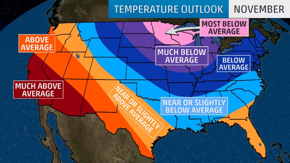 November 2019 temperature outlook from The Weather Company, an IBM Business.
 November Average Highs
 November Average Lows
November will be a cold month across the central and eastern United States as warmer than average temperatures close out autumn in the West, according to an outlook released Thursday by The Weather Company, an IBM Business.
Weather patterns in the tropics are one indicator of how temperatures might evolve in the U.S., and current conditions are similar to this time last year. These similarities are expected to continue into at least December.
Last November had unusually cold weather in most areas east of the Rockies. Medium-range computer forecast models are depicting a similar pattern to last November across the U.S. through the middle of the month.
"Given the higher confidence in a notably cold pattern in at least the first half of November, we’ve cranked up the magnitude of our negative anomalies, but have maintained the same general shape of the pattern," said Dr. Todd Crawford, chief meteorologist at The Weather Company.
The negative anomalies Crawford is referring to are below average temperatures, which are forecast to be widespread from the Northern and Central Plains eastward into the mid-South, Midwest and Northeast.
Temperatures far below average are expected in the Northern Plains, parts of the mid-Mississippi and Ohio valleys and into the southern Great Lakes.
Residents of the upper Midwest and northern Great Lakes – including portions of eastern North Dakota, Minnesota, central and northern Wisconsin and the Upper Peninsula of Michigan – will be shivering in temperatures the farthest below average in November.
On the other side of the country, above average temperatures are likely across the West and Southwest.
Areas from California into the Desert Southwest will be much above average for this time of year.
Temperatures are expected to be near, slightly above or slightly below average between the cold central and eastern U.S. and the warm West.
Average Highs in November
Average highs in November are in the 30s and 40s across the northern tier of the U.S. That means bitterly cold temperatures are likely in areas of the Northern Plains and upper Midwest that are forecast to be far below average.
Highs in the 50s are typical for November from the Pacific Northwest into the central Rockies, Central Plains, Midwest and mid-Atlantic.
November average highs are in the 60s in much of California, the Southwest, Southern Plains and Southeast. Therefore, the above average temperatures predicted in the West and Southwest will likely be warm for the final month of fall.
Average highs in the 70s are still common in November in the far southern tier of the nation.
Average Lows in November
Average lows in November are in the teens and 20s across the northern tier of the U.S. The far below average temperatures predicted in the Northern Plains and upper Midwest could potentially mean it will drop well below zero overnight.
Lows in the 30s and 40s are average for November in most other areas of the country, with 50s confined to the far southern tier. That means nights could be mild in parts of the West and Southwest, where above average temperatures are forecast.
The Weather Company’s primary journalistic mission is to report on breaking weather news, the environment and the importance of science to our lives. This story does not necessarily represent the position of our parent company, IBM.
The Weather Company’s primary journalistic mission is to report on breaking weather news, the environment and the importance of science to our lives. This story does not necessarily represent the position of our parent company, IBM.
Arctic Cold Smashes October Records in the West; Spreads to the Plains, Mississippi Valley
Brian DoneganPublished: October 31, 2019
 Current Temperatures
 This animation shows the progression of the arctic air from through Thursday. The dark purple and white contours indicate where temperatures will be the most below average each day.
 Potential Record Lows Friday Morning
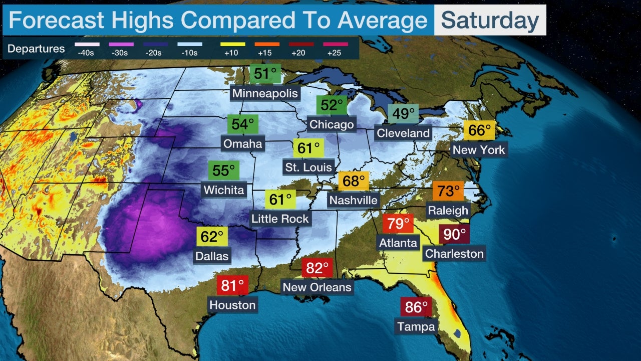
 Forecast Highs
An arctic blast is smashing daily, even monthly cold records in the West and Plains and will give a glancing blow to the East by Friday.
This latest arctic cold front is delivering temperatures more reminiscent of mid-winter, rather than late October, in the West.
Subzero cold was recorded as far south as the Grand Canyon Wednesday morning. Big Piney, Wyoming, plunged to minus 26 degrees before sunrise Wednesday.
Dozens of daily record lows have been set in the West so far this week. Even more impressively, some locations have set all-time October record lows, including:
-Bozeman, Montana: minus 14 degrees (Oct. 29 and 30)
-Casper, Wyoming: minus 9 degrees (Oct. 29 and 30)
-Grand Junction, Colorado: 7 degrees (Oct. 30)
-Livingston, Montana: minus 12 degrees (Oct. 29)
-Lubbock, Texas: 17 degrees (Oct. 31)
-Midland, Texas: 19 degrees (Oct. 31)
-Pocatello, Idaho: minus 6 degrees (Oct. 30)
-Pueblo, Colorado: minus 6 degrees (Oct. 30)
-Rapid City, South Dakota: minus 2 degrees (Oct. 30)
-Rawlins, Wyoming: minus 20 degrees (Oct. 30)
-Rock Springs, Wyoming: minus 8 degrees (Oct. 30)
-Salt Lake City: 14 degrees (Oct. 30)
-Winslow, Arizona: 12 degrees (Oct. 31)
This was the first time on record Pocatello, Idaho, and Rock Springs, Wyoming, dipped below zero in October. Casper, Wyoming, dipped below zero four straight mornings, from Oct. 27-30.
One of the nation's coldest locations, Peter Sinks, Utah, a high-elevation basin about 20 miles northeast of Logan, dipped to an incredible minus 45.5 degrees early Wednesday. This appeared to be the coldest October temperature on record anywhere in the Lower 48 states, according to Utah-based meteorologist Timothy Wright.
In the high country of California, lows dipped into the single digits in Alturas (5 degrees) and South Lake Tahoe (9 degrees) on Oct. 30.
On Tuesday, Denver and Boulder, Colorado, had high temperatures of 18 and 21 degrees, respectively. These both tied the coldest highs ever recorded in each city in October.
The biting cold air for this time of year is being funneled southward from Canada into the western and central United States by a southward plunge of the jet stream. That dip in the jet stream will slowly migrate eastward late in the week, taking the colder air with it.
Not only will it be cold, but snow is falling in the upper Midwest.
The most below average temperatures will be in the West and Plains, where highs and lows will be over 20 degrees below average, in some spots.
The cold air will slowly creep eastward late this week, giving a glancing blow, relatively speaking, to the East, where highs Friday will be only 5 to 10 degrees colder than average.
Cold Forecast Details
More daily record lows will be in jeopardy Friday morning from inland parts of California and lower Colorado River Valley into Texas.
Lows Friday morning will plunge into the 30s well into the Deep South, including the Houston metro and parts of Louisiana, Mississippi, Alabama and the Tennessee Valley.
Winds will also be gusty at times, making it feel even colder.
Numerous additional daily record-cold high temperatures are expected from the upper Midwest to the southern Plains Thursday. Highs will struggle to rise much above freezing in parts of Illinois, may be stuck in the 40s in parts of Arkansas and northeast Texas, and may hold in the 50s in central and Deep South Texas.
It will take until Friday for most of the East Coast to finally turn colder, though it won't be anywhere near as cold there as what we're seeing in the western and central U.S.
The Weather Company’s primary journalistic mission is to report on breaking weather news, the environment and the importance of science to our lives. This story does not necessarily represent the position of our parent company, IBM.
The Weather Company’s primary journalistic mission is to report on breaking weather news, the environment and the importance of science to our lives. This story does not necessarily represent the position of our parent company, IBM.
Strong Santa Ana Winds Bring Extreme Fire Danger to Southern California
weather.com meteorologistsPublished: October 31, 2019
 Fire Danger Alerts
 Wind Forecast
 Fire Weather Outlook
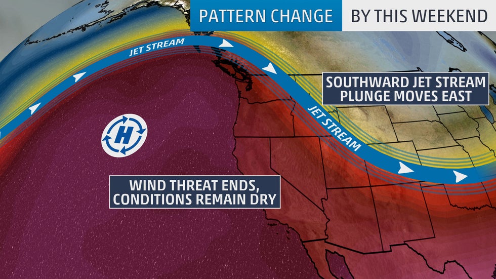 Weather Pattern This Weekend
Strong Santa Ana winds will howl through parts of Southern California Thursday, creating yet another round of dangerous fire weather conditions.
Red flag warnings for the fire danger have been posted by the National Weather Service (NWS) in parts of Southern California. The NWS said an extreme red flag warning is in effect for much of Los Angeles and Ventura counties.
Isolated wind gusts up to 70 mph are possible in the Los Angeles County mountains Thursday, and relative humidity could drop into the single digits. Gusts could reach 60 mph in other parts of Ventura and Los Angeles counties.
"These winds will result in a significant threat for large fast-moving fires and wind damage (like downed trees, power lines and broken signs or overhangs)," warned the Oxnard/Los Angeles NWS forecast office.
Winds are expected to diminish Thursday afternoon.
Extremely critical fire weather conditions are forecast on Thursday in parts of Southern California, according to NOAA's Storm Prediction Center. Conditions are expected to improve by Friday.
Pattern Change to End Extreme Fire Danger
A weather pattern change beginning Friday will be good and bad news for California.
The recent weather pattern has featured a southward plunge of the jet stream over the West. At the same time, multiple strong high-pressure systems built into the Rockies and Great Basin. When that setup is in place, California usually has bouts of strong winds and low humidity.
By Friday, the jet stream will build northward along the West Coast as its corresponding southward plunge moves toward the central and eastern states. That will put an end to the threat of strong winds in California into early next week.
The bad news is that this same weather pattern will also prevent any chances for rain in California for the foreseeable future.
What California needs is for the jet stream to dive southward over the Eastern Pacific Ocean and then pivot eastward into the West Coast. That would open the door for moisture-laden Pacific storms to spread into the state.
Until a significant soaking arrives this fall, the potential for large and rapidly spreading wildfires will continue if any bouts of strong winds return.
The Weather Company’s primary journalistic mission is to report on breaking weather news, the environment and the importance of science to our lives. This story does not necessarily represent the position of our parent company, IBM.
The Weather Company’s primary journalistic mission is to report on breaking weather news, the environment and the importance of science to our lives. This story does not necessarily represent the position of our parent company, IBM.
Severe Thunderstorms With Damaging Winds Threaten the East on Halloween
weather.com meteorologistsPublished: October 31, 2019
 Thursday's Thunderstorm Threat
 Trick-or-Treat Forecast
Severe thunderstorms will threaten Halloween in the mid-Atlantic and South as a strong cold front moves through the East.
A large area in the East will see showers and thunderstorms Thursday into Thursday night, from the Southeast to the mid-Atlantic and Northeast.
The greatest risk for severe thunderstorms will stretch from parts of the Carolinas into Pennsylvania, including Raleigh, North Carolina, Richmond, Virginia, and Washington, D.C.
Forecast guidance shows a squall line of thunderstorms moving eastward through these areas during the late afternoon and evening hours. Some of those storms will be severe with damaging wind gusts being the primary threat, but an isolated tornado cannot be ruled out.
If you have trick-or-treating plans, be sure you have a way to receive warnings and a plan to seek shelter if the storms hit your area.
National Halloween Evening Forecast
Showers and thunderstorms will remain likely in parts of the Northeast and mid-Atlantic into Halloween evening.
The storm system will continue to march eastward during the afternoon hours but may clear out just in time for trick-or-treating from Cincinnati to Atlanta.
Snow or a mix of rain and snow is possible in the Great Lakes as cold air wraps around the low-pressure system.
Give your mummies a few extra layers across the West and Plains, where temperatures will be much colder than average for the final day of October. Evening temperatures will be in the teens and 20s from Colorado to Montana.
The Weather Company’s primary journalistic mission is to report on breaking weather news, the environment and the importance of science to our lives. This story does not necessarily represent the position of our parent company, IBM.
Early-Season Snowstorm to Spread Across Great Lakes on Halloween
weather.com meteorologistsPublished: October 31, 2019
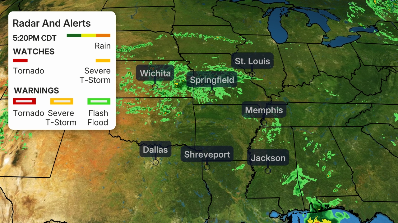 Current Radar
 Snowfall Forecast Through Thursday
An early-season snowstorm will finish up in the Great Lakes on Halloween after bringing snow to parts of the Plains, Midwest and Rockies earlier in the week.
The Weather Channel has named this system Winter Storm Bessie.
Light to locally moderate snow was spreading from the mid-Mississippi Valley into the western Great Lakes on Thursday morning, including Milwaukee and parts of Chicagoland. Slushy accumulations could slow down travel in these areas.
Rain changing to snow will also pivot through other parts of the Great Lakes region through Thursday night, including Indiana, Michigan, northern Ohio and northwestern Pennsylvania.
The heaviest snow from this storm has already fallen in the Rockies. Additional accumulations in the Great Lakes region will be light with most areas receiving 3 inches or less.
Gusty winds will also accompany the storm in the Great Lakes as the area of low pressure moves through. The strongest winds will be in western New York where gusts up to 65 mph are possible Thursday night into Friday. Those winds could down trees and knock out power.
Storm Recap
Denver picked up 7.7 inches of snow at Denver International Airport as this snowstorm dropped southward through the Rockies Tuesday into Wednesday.
A burst of heavier snow moved through the Chicago metro area early Wednesday morning. Western suburbs of the city received 1 to 3 inches of slushy accumulation.
The Weather Company’s primary journalistic mission is to report on breaking weather news, the environment and the importance of science to our lives. This story does not necessarily represent the position of our parent company, IBM.
The Weather Company’s primary journalistic mission is to report on breaking weather news, the environment and the importance of science to our lives. This story does not necessarily represent the position of our parent company, IBM.
Hillside Fire Burning Into San Bernardino Neighborhoods, Evacuations Underway
Ron Brackett and Jan Wesner ChildsPublished: October 30, 2019
Firefighters battle to protect the Ronald Reagan Presidential Library from the Easy Fire in Simi Valley, California, on Oct. 30, 2019.
Firefighters prepare to put out flames on the road leading to the Ronald Reagan Presidential Library during the Easy Fire in Simi Valley, California, on Oct. 30, 2019.
Laura Horvitz (R) and Robyn Phipps help rescue goats from a ranch near the Ronald Reagan Presidential Library in Simi Valley during the Easy Fire in Simi Valley, California, on Oct. 30, 2019.
Residents of north San Bernardino were forced to flee their homes overnight as a fast-moving wildfire burned through neighborhoods.
The Hillside Fire had burned through 200 acres as of 3 am local time, shutting down a stretch of highway 18 as it burned out of control.
Video taken by local media showed homes and other structures on fire.
The new fire follows several others on Wednesday in Southern California, including a fast-moving wildfire in Ventura County, California, which came dangerously close to the Ronald Reagan Presidential Library Wednesday morning.
Nearby residents fled with whatever belongings they could carry and scrambled to get horses and other livestock out of harm's way.
Mandatory evacuations were ordered after the blaze, known as the Easy Fire, started just before 7 a.m. local time and burned close to several neighborhoods in the Simi Valley.
The fire burned more than 2 square miles within just a few hours.
Another fire that broke out mid-morning in Jurupa Valley, east of Los Angeles in Riverside County, also forced evacuations, including at a nursing home, where several patients in wheelchairs and stretchers were helped out by workers as thick plumes of smoke shot into the sky, KABC-TV reported. Groups of patients were seen wearing face masks, waiting for transportation near a roadway off-ramp.
The blaze was named the Hill Fire. It had burned about 200 acres and was 5% contained, according to Cal Fire. One civilian had sustained minor injuries, and a house and mobile home were damaged.
The Easy Fire was threatening 7,000 homes affecting 26,000 residents, officials said in a Wednesday afternoon press conference. Most of those were under the mandatory evacuation order.
"The fire outflanked us very rapidly today, pushed by those 40 to 45 mph winds," said Ventura County Fire Department Assistant Chief Chad Cook, adding that gusts reached 60 mph and aerial operations had to be grounded at times.
Cook, who is the incident commander, said firefighters were in defensive mode.
"We have resources all around the incident right now, actively engaged in structure protection and lifesaving measures."
Several outbuildings had burned and there were reports of at least one home in flames.
Cook said no structures in the fire's path were safe.
"The entire footprint of the fire is still under threat," he said.
"We have several structures that are impacted by the fire. Hundreds are in the footprint of the fire."
The cause of the fire was under investigation, but Southern California Edison filed a report with state regulators that said it began near power lines owned by the utility, the Associated Press reported.
Melissa Giller, spokeswoman for the Reagan library, said flames started coming up the back part of the museum property at about 9 a.m. local time.
Giller described the harrowing scene to The Weather Channel late Wednesday morning.
"It got to about, within about 50 feet, of the Reagan library, to the outskirts. The firefighters threw water drops and on-ground firefighters were able to turn the fire around. But now, from what I’m seeing on the news and what I’m hearing is now the fire coming up the front side, the complete opposite of our property," Giller said.
A handful of employees were onsite monitoring the situation.
"They said that even though the fire is sort of circling the library, they still feel completely safe," Giller said. "The amount of water drops that the fire department is doing … they are dropping so much water that the museum building itself and all of our buildings are completely safe."
At the press conference, Cook said the immediate threat is expected to continue through the week.
"I would say the next couple of days could prove very busy for all fire resources in Southern California," he said.
Ventura County Fire Chief Mark Lorenzen had this message for residents: "Pay attention to your media outlets and social media and be ready to leave. And when we ask you to leave, please leave immediately."
Residents and volunteers rushed to rescue horses, goats and other animals ahead of the fire. At least one large animal shelter was full, and spooked horses had to be coaxed into trailers.
“When they get agitated and excited, you have to be firm,” Fia Perera, who was dealing with her two horses and her 900-pound pig, told the Los Angeles Times. “If you’re panicky, they pick up on your energy.”
Many fled their homes with very few belongings in the rush to get safety. Cellphones buzzed with emergency messages and law enforcement officers went door to door telling people to leave.
"Everything started rolling so fast," Elena Mishkanian told the AP.
Simi Valley Schools announced that classes were canceled. Moorpark College and Moorpark Unified School District are also closed, as well as dozens of other schools in Ventura County that shut down due to power outages and the fire threat.
More than a million people remained without electricity Wednesday morning due to precautionary shutoffs aimed to prevent wildfires. Pacific Gas and Electric started shutting off power Tuesday to some 540,000 customers in parts of 27 counties, the utility said in a press release. Southern California Edison had cut electricity to about 40,000 customers and was warning another 300,000 could lose power.
All told, estimates say the outages affect more than 1.5 million people when taking into account household size and other factors.
"One of the things that gives us the most concern with this particular kind of weather is debris flying into equipment," Robert Villegas, a Southern California Edison spokesman, told The Weather Channel.
Villegas said most of the affected Southern California customers were in Ventura County where the Easy Fire was burning.
The outages come as some people are still without power from a similar outage over the weekend, or have just had their power restored.
The Easy Fire and the Hill Fire were two of several blazes that started Wednesday while others continued to burn, including the Getty Fire and the Kincade Fire.
Getty Fire
The Getty Fire began on the west side of the 405 freeway near the Getty Center about 1:30 a.m. Monday, according to the Los Angeles Fire Department. In a Tuesday afternoon press conference, Los Angeles mayor Eric Garcetti said the blaze was started when a tree branch was blown onto a power line by strong winds. The incident was captured on dashcam footage.
By Wednesday, it had spread to just over 1 square mile and threatened more than 7,000 structures. It was about 25% contained.
Evacuations were ordered from Mulholland Boulevard south to W. Sunset Boulevard, east to the 405 and west to Temescal Canyon Road. Monday afternoon, residents of the Mountaingate community on the eastern edge of the evacuation zone were told they could return home.
Twelve homes were destroyed in the fire and another five were damaged. More than 700 firefighters were on the scene.
Los Angeles Fire Department Chief Ralph Terraza said of the firefighters battling the Getty Fire, "They were literally overwhelmed. They had to make some tough decisions on which houses they were able to protect. Many times it depends upon where the ember lands."
Kincade Fire
In Northern California, firefighters appeared to be making headway on the Kincade Fire, which had burned nearly 120 square miles and was 30 percent contained as of Wednesday morning. The fire, which started on Oct. 23 near Geyserville, has destroyed at least 206 structures, including 94 homes.
More than 90,000 structures were threatened and 126,000 people were under evacuation orders, although many were allowed to return home Tuesday and Wednesday.
Two firefighters were injured on Sunday near the fire, including one that had to be airlifted due to his burns. He was taken to the UC Davis Medical Center and was listed in stable condition on Tuesday, according to a Cal Fire official speaking at a morning news conference. The second firefighter sustained minor burn injuries.
The Weather Company’s primary journalistic mission is to report on breaking weather news, the environment and the importance of science to our lives. This story does not necessarily represent the position of our parent company, IBM.
The Weather Company’s primary journalistic mission is to report on breaking weather news, the environment and the importance of science to our lives. This story does not necessarily represent the position of our parent company, IBM.
Does November Weather Deserve Its Bad Reputation?
Jonathan Erdman and Chris DolcePublished: October 30, 2019
 This map shows the average November cloudiness from 1966 to 1996.
 Month of the average first accumulating (0.1 inches or greater) snowfall of the season, according to 30-year average statistics. In parts of the South, measurable snow is most likely to occur in January or February, but not every year. Version corrected for the Oregon coast on Sept. 30, 2017.
 Cars with snow atop the roofs sit idle at this home on Broadway in Lancaster, New York, Wednesday, Nov. 19, 2014.
 In this Jan. 18, 2017 file photo, pedestrians huddle under umbrellas as they walk past the Pike Place Market and in view of Elliot Bay, behind, in Seattle.
 The highest chance of tornadoes in November is near the Gulf Coast.
 Hurricane Kate in the Gulf of Mexico.
 Dry season setup.
 California's wet season kicks into gear by November.
When you think of November weather, what crosses your mind?
In 1991, the legendary rock band Guns N' Roses released a song about cold "November Rain."
John Facenda, the iconic voice of NFL Films, once uttered the following in a song simply titled "November":
November can be cold and gray. November can be surly, with bitter rain upon the world and winter coming early.
Since it's the beginning of the handoff between fall and winter, November can be a trying month. But there are also some good aspects of November weather that some can't wait for.
Let's start with November's gloomy aspects.
It Kicks Off the Cloudiest Time of Year, For Some
By November, some in the northern U.S. may have to begin taking their vitamin D supplement.
It's typically the cloudiest month of the year in parts of the northern Plains and upper Midwest, including the Twin Cities and Milwaukee, Wisconsin, according to Alaska-based climatologist Brian Brettschneider.
In other parts of the Midwest and interior Northeast, that cloudy peak arrives in December, but November kicks it off.
An average November sky is at least 70% cloud-covered around the Great Lakes, interior Northeast and Pacific Northwest.
The Season's First Measurable Snow Arrives For Many
For many cities in the Northeast, Midwest and West, the average first measurable snow – defined as 0.1 inches or more – has historically arrived in November.
A few of the cities that, on average, see the first accumulating snow of the season in November are Boston (Nov. 29), Chicago (Nov. 16), Cleveland (Nov. 10), Pittsburgh (Nov. 14) and Salt Lake City (Nov. 5).
The date shown for each city is the historical average for the first date of measurable snow. Any given season can produce the season's first snowfall before or after that date, depending on weather patterns.
Lake-Effect Snow Ramps Up
The potential for lake-effect snow bands to develop downwind of the Great Lakes increases significantly in November.
Cold air flowing over relatively warm Great Lakes water is the key mechanism for lake-generated precipitation. Although lake-effect snow can occur in October, the chances increase in November given that cold air is generally more abundant the later we get into fall.
Great Lakes snowbelt cities such as Buffalo, New York, and Grand Rapids, Michigan, typically pick up 6 to 8 inches of snow each November. Marquette, in Michigan's Upper Peninsula, gets about two feet of snow in an average November.
The week before Thanksgiving 2014 featured an epic lake-effect snow event in the eastern Great Lakes. Localized snowfall totals of more than 70 inches were measured in the Buffalo Southtowns; an astonishing 88-inch total was reported in Cowlesville, New York.
November 'Witch' Storms
Some November storms don't make news from wringing out snow.
As temperature contrasts increase from north to south across the country, storm systems that develop are stronger in fall. The more intense those low-pressure systems become, the stronger the winds they can produce.
GOES-16 GeoColor satellite images taken at 8 a.m. EDT, Oct. 23, 2017 (first image), then 24 hours later, showing the bombogenesis of a Great Lakes storm. (Note: City lights overlay is applied in these images.)
Early November – and late October, for that matter – has a long, notorious history of intense Midwest windstorms. If you live in that region of the country, you might have heard of the "Witches of November," used to describe these storms that often pack powerful winds.
Those low-pressure systems can have winds so strong that they cause tree damage and power outages. One such November Witch struck parts of the Midwest and Great Lakes in early November 2015, downing trees and causing power outages.
The storms are a major hazard for shipping on the Great Lakes. One of the most well-known storms sank a huge iron-ore ship called the Edmund Fitzgerald while it was on Lake Superior in November 1975.
Wettest Month in a Notoriously Wet Northwest
November also marks the intensification of the wet season along the West Coast.
For Portland, Oregon, and Seattle, November averages more precipitation than any other month during the year, although December and January aren't far behind.
From November through January, measurable precipitation typically falls 18 days per month in Seattle.
As Pacific storm systems plow inland, they can occasionally tap into a so-called atmospheric river, a narrow plume of moisture extending into the tropics or subtropics.
The atmospheric river provides extra juice for storm systems taking aim at the West Coast. Sometimes, the extra moisture can be overwhelming, with heavy rain causing flooding while feet of snow pile up in higher terrain.
Although these atmospheric river events can bring hazardous impacts, they are also beneficial since they help replenish the water supply in the West.
Severe Weather's Fall Peak
While severe weather can occur any time of year when favorable conditions are in play, November has often been a dangerous month for severe weather outbreaks.
With jet stream winds becoming stronger in the fall, and lingering warm, moist air available at times, the atmosphere can become unstable. As a result, severe thunderstorms with damaging winds, large hail and occasional tornadoes can develop.
Most of the time, these fall tornado outbreaks occur in the Gulf Coast states, where warm, moist air is more common, but they can sometimes spread farther north.
One such outbreak that occurred far from the Gulf Coast was on Nov. 17, 2013. Damaging tornadoes were spawned in several Ohio Valley and Great Lakes states.
In November 2016, more than three dozen tornadoes hit the South during the final two days of the month. Three of the tornadoes were rated EF3, and two of them killed a combined six people.
The largest fall tornado outbreak struck the South Nov. 21-23, 1992. A total of 105 tornadoes touched down in three days, killing 26 people.
But November isn't all gloom and doom. Let's list some of the positives.
U.S. Hurricane Risk Winds Down
November is the last month of the Atlantic hurricane season, but both the number of named storms and risk to the U.S. is much lower than earlier in the fall.
One named storm typically forms every other November somewhere in the Atlantic Basin.
Only three hurricanes have struck the U.S. in November.
Hurricane Kate made landfall in Florida days before Thanksgiving 1985, marking the latest hurricane landfall in U.S. history.
More recently, Ida in 2009 became the first hurricane since Kate to move into the Gulf of Mexico during the month of November. Ida became a post-tropical storm shortly before reaching the Alabama coast on Nov. 10.
By early Nov. 12, the remnants of Ida had transformed into a powerful non-tropical low-pressure center near the coast of the Carolinas. The Weather Channel dubbed this storm "Nor'Ida," given it's nor'easter-like characteristics.
Nor'Ida then lashed southeastern Virginia and the Outer Banks of North Carolina with coastal flooding, heavy rain and damaging winds as it stalled near the coast.
Florida Begins Its Dry Season
Floridians enjoy the arrival of the state's dry season by November as more northern locations are trending colder.
Florida typically dries out by late October, and it stays dry through early spring as cold fronts return to the Sunshine State.
Days could still be warm, but by November, the humidity is lower and temperatures typically cool down at night.
This can make November a delightful time of year to visit. For instance, in Orlando, average high temperatures top out from the mid-70s to low 80s.
Behind these fronts, cooler air near the surface stabilizes the atmosphere, suppressing the almost daily showers and thunderstorms seen in the summer.
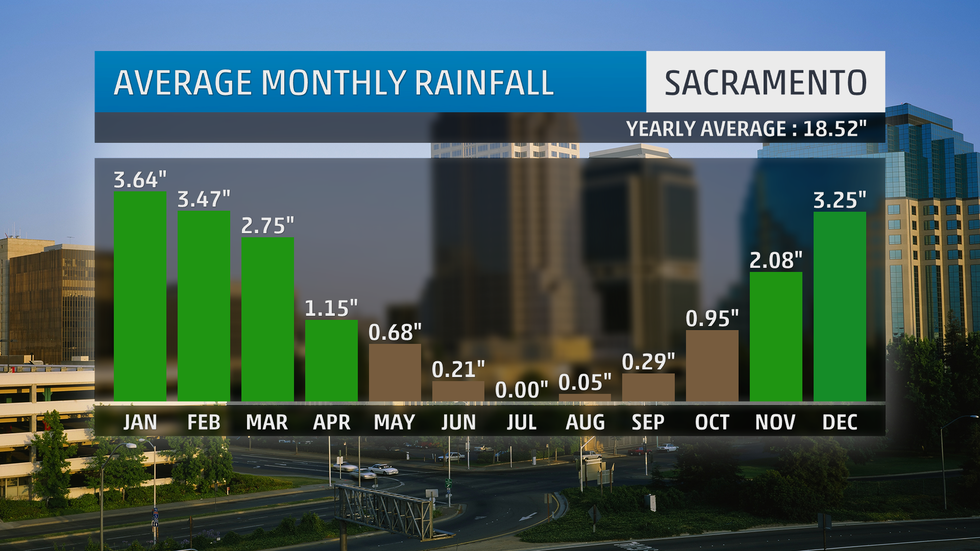
Rain in California, At Last
Transplants looking to escape more miserable cold, rain or snow sent California's population skyrocketing in recent decades.
By November, however, some Californians would welcome rain, even if it messes up the daily commute.
The state has a pronounced dry season, with little rainfall from late spring through early fall. By October, vegetation dried out after months of no significant rain serves as fuel for fast-spreading wildfires fanned by Santa Ana and Diablo winds.
California's roughly six-month-long wet season usually ramps up by November, as the jet stream gradually shifts south. This directs Pacific storms not simply into Washington and Oregon, but increasingly into California as well.
As mentioned earlier, some of these West Coast storms with atmospheric rivers can trigger flooding rain, and wildfire-charred land can experience debris flows even in lighter rain.
But overall, this first rain of the wet season can finally provide a break for fatigued fire crews and first responders.
Skiers and snowboarders also love these November storms in the West, as they build up snowpack for those who can't wait to hit the slopes.
The Weather Company’s primary journalistic mission is to report on breaking weather news, the environment and the importance of science to our lives. This story does not necessarily represent the position of our parent company, IBM.
The Weather Company’s primary journalistic mission is to report on breaking weather news, the environment and the importance of science to our lives. This story does not necessarily represent the position of our parent company, IBM.
Subscribe to:
Comments (Atom)
Man missing at sea for nearly 2 weeks found alive in life raft off Washington coast
One of two men missing at sea for nearly two weeks was found alive on Thursday by a Canadian fishing boat in a life raft in Canadian water...

-
Jonathan Erdman Published: October 26, 2023 Louisiana and Mississippi are experiencing their most widespread "exceptional" droug...
-
Chris Dolce Published: April 6,2020 Tropical Cyclone Harold underwent a last-minute burst of intensification before it hit Vanuatu an...
-
Linda Lam Published: August 11, 2020 Severe weather, including tornadoes, derechos and flash flooding, can result in dangerous conditions ...


