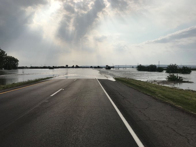
After severe weather outbreaks hammered areas from Texas to Kansas and Missouri earlier this week, more severe weather and flooding will threaten these same areas into the Memorial Day holiday weekend.
A tornado outbreak followed on Wednesday afternoon and night in northeastern Oklahoma and Missouri. One tornado killed three people in Golden City, Missouri.
A large tornado also struck the capital city of Jefferson City, Missouri, producing extensive damage. There have been no confirmed fatalities in Jefferson City at this time.
More severe weather will threaten areas from western Texas to Iowa and Missouri into the Memorial Day holiday weekend, partially due to a large and persistent dip in the jet stream across the western United States.
Each storm system that dives through the West and Four Corners region has nowhere to go but into the southern and central Plains. When these systems interact with moisture and humidity being drawn northward from the Gulf of Mexico, the ingredients come together for severe weather outbreaks.
As one of these systems ejects onto the Plains, more severe thunderstorms will ignite across the Plains into Thursday night.

The main threats will be damaging wind gusts, flooding downpours and incidents of large hail.
Tornadoes can also be produced with the risk for the most destructive tornadoes (EF-2 strength or greater) highest in the Texas Panhandle.
Cities that lie within the threat zone into Thursday night include Kansas City, Missouri; Wichita, Kansas; Woodward and Enid, Oklahoma; and Amarillo and Lubbock, Texas.
"In addition to the damaging aspect of the severe weather, the thunderstorms can repeat over the same areas and be followed by a period of drenching rain, which can exacerbate the flooding across the region," according to AccuWeather Senior Meteorologist Kristina Pydynowski.

On Friday, another round of severe storms and flooding downpours will erupt in nearly the same region of the southern Plains but expand to around Chicago along the northern edge of a dome of heat building across the South.
Saturday's danger will be nearly identical to the zone on Friday.

All modes of severe weather can be expected Friday and Saturday, from damaging winds to large hail, flooding downpours and isolated tornadoes.
Because multiple storms may move repeatedly over the same locations late this week, flooding will again be a major concern. Some communities may receive another 3 to 6 inches of rain on top of what already fell early this week with an AccuWeather Local StormMax™ of 12 inches.

Oklahoma City has received nearly 10 inches of rain already this month, which is more than double what the city typically receives for the entire month.
Many rivers from Oklahoma to Missouri and Illinois are currently in moderate to major flood stage. The additional rainfall can further push these waterways and streams further out of their banks, further flooding neighboring land and communities.
Bird Creek at Avant, Oklahoma, reached a record crest of 36.52 feet on Tuesday, breaking the old record crest by over 4 feet.
With volume on the roadways increasing late this week ahead of the Memorial Day weekend, motorists can expect even longer travel delays on parts of interstates 40, 70 and 80, as well as surrounding roadways, as a result of the stormy weather.
Officials are urging travelers to check road conditions as some highways have been closed due to flooding. This includes a stretch of I-40 in eastern Oklahoma near Webbers Falls.
Be sure to reduce speeds on wet roadways and in heavy downpours to reduce the risk for hydroplaning when traveling at highway speeds. Never drive through a flooded road to avoid a potentially deadly situation.
In addition, large hail can cause serious damage to crops and vehicles not under a garage or protective covering and also endanger the lives of anyone caught outdoors.
Related:
Clean-up beings as fallen trees block road
Tree falls on man, fire crew responds
Violent tornadoes tear across Missouri, killing 3 and leaving extensive damage
AccuWeather predicts substantial 2019 corn and soybean yield shortfall
Clean-up beings as fallen trees block road
Tree falls on man, fire crew responds
Violent tornadoes tear across Missouri, killing 3 and leaving extensive damage
AccuWeather predicts substantial 2019 corn and soybean yield shortfall
If a severe thunderstorm or tornado warning is issued for your community, be sure to seek shelter inside a basement or storm shelter away from doors and windows to lessen the threat for death or injuries.
Download the free AccuWeather app to keep up to date on the latest severe weather alerts. Keep checking back for updates on AccuWeather.com and stay tuned to the AccuWeather Network on DirecTV, Frontier and Verizon Fios.
Have a backup generator handy, if possible, since the strong winds can knock down trees and power lines, leading to widespread power outages.

Unfortunately, the weather pattern responsible for the severe weather shows no signs of changing through the Memorial Day weekend. Residents in the Central states should remain vigilant and be prepared for additional rounds of severe weather through early next week.


No comments:
Post a Comment