By Adriana Navarro, AccuWeather staff writer
By Chaffin Mitchell, AccuWeather staff writer
Another round of severe weather continues to roll through the central United States as the storm system that spawned nearly 40 preliminary tornado reports in Nebraska and Kansas Friday and Friday night tracks eastward. The severe weather is expected to continue through Sunday.
At least 11 tornadoes have been reported through Saturday night, according to the National Weather Service's Storm Prediction Center. All have occurred in Oklahoma and Texas.
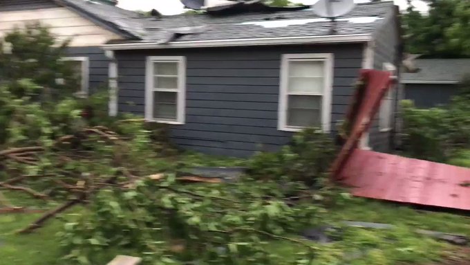
Around 7:36 a.m. CDT, a tornado tore through Ballinger, Texas, causing at least one possible injury and demolishing a house off of FM2111. According to the report, the damage track in Ballinger stretches from the country club to a local high school. The tornado also snapped trees, downed power lines and damaged a baseball stadium and a water tower. There have been reports of flooding in some homes around the area.
Not even five minutes after the Ballinger tornado occurred, another tornado was reported in Geronimo, Oklahoma, at 7:38 a.m. CDT, damaging homes and trees. Area emergency management noted that the tornado may have begun as early as 7:35 a.m. CDT.

(Twitter/NWSNorman)
Damage survey confirms an EF2 tornado caused the damage east of Geronimo, Oklahoma, early this morning.

(Twitter/NWSNorman)
Damage survey confirms an EF2 tornado caused the damage east of Geronimo, Oklahoma, early this morning.

Damage from the tornado in Abilene, Texas on Saturday.

(Photo/Instagram user Michael Nixon)
Storm damage seen in Fort Smith, Arkansas, on May 18, 2019.

(Photo/Instagram user Michael Nixon)
Trees toppled onto cars after a possible tornado touched down in Fort Smith, Arkansas, on May 18, 2019.

(Photo/Instagram user Michael Nixon)
Several large trees were uprooted after an apparent tornado ripped through this neighborhood in Fort Smith, Arkansas.

(Photo/Instagram user Michael Nixon)
Power lines were nearly blown over in Fort Smith, Arkansas, on May 18, 2019.

(Twitter photo/@ImAHerkPilot)
A tornado-warned storm passed through Abilene, Texas, early Saturday morning, demolishing homes and downing power lines.

(Twitter photo/@ImAHerkPilot)
A tornad-warned storm passed through Abilene, Texas, early Saturday morning, downing power lines in its path.

(Instagram photo/@foxx2487)
A drone captured possible tornado damage in Abilene, Texas, on Saturday, May 18.

(Twitter photo/@ImAHerkPilot)
On the second day of severe weather this weekend, a tornado-warned thunderstorm blew through Abilene, Texas, damaging several homes.

(Instagram photo/@foxx2487)
A drone captured possible tornado damage in Abilene, Texas, on Saturday, May 18.

(Instagram photo/@foxx2487)
A drone captured possible tornado damage in Abilene, Texas, on Saturday, May 18.

(Twitter photo/@ImAHerkPilot)
The gusty, tornado-warned storm that blew through Abilene, Texas, overturned a U-Haul and tore street signs from the ground.

(Instagram photo/@foxx2487)
A drone captured possible tornado damage in Abilene, Texas, on Saturday, May 18.

(Twitter photo/@ckillgore6)
Warehouse roofs were torn from multiple units amid a tornado-warned storm in San Angelo, Texas, early Saturday morning.

(Twitter photo/@ckillgore6)
A tornado-warned storm damaged storage units in San Angelo, Texas, early Saturday morning.

(Twitter photo/@ckillgore6)
Several mini warehouse units were damaged by the time the tornado-warned storm had blown through San Angelo, Texas, Saturday morning.

(Twitter photo/@@punkrockgirl68)
Dark clouds hung over north Texas on Saturday, May, 18, as severe weather rolled through the region.

@KHPAircraft
The tornado in Ford County, Texas on Friday night carved a path through the field. (Twitter/@KHPAircraft)

@KHPAircraft
The tornado that carved through Ford County, Texas hit a farm, damaging a few of the buildings. (Twitter/@KHPAircraft)

@TimothyChippARN/@ReporterNews
Tree damage from the tornado-warned storm that passed through Abilene, Texas on Saturday morning. (Twitter/@TimothyChippARN/@ReporterNews)

@TimothyChippARN/@ReporterNews
Tree damage from the tornado-warned storm that passedd over Abilene, Texas early Saturday morning. (Twitter/@TimothyChippARN/@ReporterNews)
@TimothyChippARN/@ReporterNews
Tree damage from the tornado-warned storm that passedd over Abilene, Texas early Saturday morning. (Twitter/@TimothyChippARN/@ReporterNews)
A third tornado hit Silver Valley, Texas, at 8:39 a.m. CDT, scattering downed trees across roads and damaging a church roof.
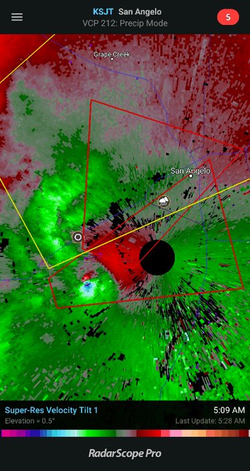
Earlier Saturday morning just before 5 a.m. CDT, a tornado-warned storm passed near San Angelo and Abilene, Texas. The National Weather Service survey team continues to assess the tornado damage from this morning.
They have concluded that the damage in the Bradford area of San Angelo is at least EF2.

@NWSSanAngelo @spann @TxStormChasers looking north from loop 306 and Knickerbocker Rd with per flashes to the north as the circulation passed over San Angelo. Time was 05:33 am CDT

21 people are talking about this
The San Angelo National Weather Service (NWS) had to transfer operations and take shelter as the storm hit.
A resident in Abilene, Texas, tweeted about flipped cars and damage to a nursing home after another tornado-warned storm swept through the area.
Local news coverage captured a video of the damage in Abilene, showing downed trees and power lines in the road beside damaged homes.

The Dallas-Fort Worth International Airport had canceled over 560 flights and delayed another 515 others as of late Saturday evening, according to FlightAware.
Over 100,000 customers were left without power from Texas to Iowa during the height of the storms on Saturday.
Saturday is only the second day of what could be more than a week-long severe outbreak over the center of the country. AccuWeather Meteorologist Brandon Buckingham warns that as the days progress, the flood threat will continue to increase over areas that have round after round of rain and thunderstorms.

"Tornado Alley is certainly waking up with significant severe weather," AccuWeather Extreme Meteorologist Reed Timmer said while reporting on the multi-day outbreak for the AccuWeather Network. He noted that this is the worst setup for severe weather he has seen in years. While reporting and chasing storms on Friday, Timmer intercepted a tornado on foot near McCook, losing his hat in the process.
Download the free AccuWeather app to stay alert to severe storm and tornado warnings in your area. Keep checking back for updates on AccuWeather.com and stay tuned to the AccuWeather Network on DirecTV, Frontier and Verizon Fios.

RELATED:
6 life-threatening tornado myths debunked
How to stay safe when severe weather strikes at night
The difference between tornado watches and warnings
Reed Timmer survives wild close-up encounter with powerhouse tornado in Nebraska
6 life-threatening tornado myths debunked
How to stay safe when severe weather strikes at night
The difference between tornado watches and warnings
Reed Timmer survives wild close-up encounter with powerhouse tornado in Nebraska
6:50 a.m. CDT Sunday
Emergency management reported demolished gas pumps at a station in Ville Platte, Louisiana around 5:57 a.m. CDT after a possible tornado.
The tornado watch for Rapides and Vernon Parish, Louisiana has been canceled
5:50 a.m. CDT Sunday
The NWS has extended a tornado watch to include areas west of I-55 from Summit/McComb, Mississippi to Laplace, Louisiana. The watch is set to expire at 10 a.m. CDT Sunday.


See NWS New Orleans's other Tweets
4:15 a.m. CDT Sunday:
The threat of isolated tornadoes, along with damaging winds and flooding downpours, continues to spread eastward early this morning, with portions of western Mississippi now at risk.
Tornado Watch 191 that is in effect until 10 am has been expanded east and now includes Hinds, Madison, Rankin, Simpson, Copiah, Lincoln and Lawrence.
Morehouse, West Carroll, Richland and Franklin Parishes have been removed from the watch.

See NWS Jackson MS's other Tweets
Meanwhile, damage reports are coming out of southwestern Louisiana where a possible tornado tore through earlier this morning. Seven miles north-northeast of Singer, Louisiana, there are reports of lots of trees down on Jim West Road. A tree also fell onto a home 4 miles north-northeast of Singer.
3:30 a.m. CDT Sunday:
The NWS has stated that a confirmed large and extremely dangerous tornado was located near De Ridder, Louisiana, moving northeast at 30 mph. Take cover now!
3:12 a.m. CDT Sunday:
There are two tornado warnings ongoing in Louisiana.
One is located in southwestern portions of the state and could impact Singer, Deridder and Tulla.
The second tornado-warned thunderstorm is located in northeastern portions of the state and could impact Delhi, Warden, Waverly, Monticello, Darnell and Alsatia. This storm has a radar confirmed tornado with it, according to the National Weather Service.
"At 3:11 a.m. CDT, a confirmed tornado was located over Holly Ridge, or 10 miles east of Rayville, moving northeast at 35 mph," the NWS warning said.

Tornado Warning including Delhi LA, Epps LA, Darnell LA until 4:00 AM CDT
See NWS Jackson MS's other Tweets
Meanwhile, 80 homes in West Springfield, Missouri, are without power after strong thunderstorm winds downed a tree onto power lines.
2:30 a.m. CDT Sunday:
While most of the severe weather activity is occurring in Louisiana at this hour, there remains a severe thunderstorm warning for portions of southwest Missouri, including Springfield.

1:50 a.m. CDT Sunday:
Powerhouse thunderstorms are plowing through central Louisiana, packing heavy rain, high winds and frequent lightning.
A new tornado watch has been issued for the region until 10:00 a.m. CDT Sunday.

A tornado watch has been issued for parts of Louisiana and Mississippi until 10 AM CDT

See NWS Shreveport's other Tweets
12:35 a.m. CDT Sunday:
A severe thunderstorm with a history of producing wind gusts as high as 70 mph continues to roll through southeastern Kansas at this time.
Power lines and 3-inch diameter tree limbs were downed by these powerful winds in Niotaze, Kansas.

Severe Thunderstorm Warning including Pittsburg KS, Fort Scott KS, Frontenac KS until 1:30 AM CDT
See NWS Springfield's other Tweets
11:00 p.m. CDT Saturday:
Slow-moving thunderstorms are causing major flooding problems in portions of eastern Texas. Highway 84 has been closed due to high water in Reklaw, according to local emergency managers. A high water rescue was also requested for a stranded vehicle at White Oak Road in this town.
Roads have been closed due to flash flooding in Cushing, Texas.

8:30 p.m. CDT Saturday:
A tornado warning is in effect to the north over Medicine Lodge, Kansas as of 8:14 p.m. CDT.
Severe storms are also near Nash, Oklahoma, where AccuWeather Extreme Meteorologist Reed Timmer is located.

NEW: turbulent skies over Nash OK behind severe storm!
A #tornado warning is in effect to the north over Medicine Lodge KS as of 814 pm CDT!@breakingweather @accuweather

61 people are talking about this
7:25 p.m. CDT Saturday:
Potent thunderstorms are marching across the central US this evening and have left over 133,000 without power across Texas, Arkansas, Nebraska, Missouri, and Oklahoma.

6:30 p.m. CDT Saturday:
Damage survey confirms an EF2 tornado caused the damage east of Geronimo, Oklahoma early this morning.


Damage survey confirms an EF2 tornado caused the damage east of Geronimo early this morning. Path was very short but winds were strong.

108 people are talking about this
5:45 p.m. CDT Saturday:
The National Weather Service survey team continues to assess the tornado damage from this morning. They have concluded that the damage in the Bradford area of San Angelo, Texas is at least EF2.

63 people are talking about this
5:15 p.m. CDT Saturday:
Trees and power lines are down across Fort Smith, Arkansas, as well as structural damage to some buildings.
"Residents, please avoid areas of downed trees until they are secured by Fort Smith Fire Department or Fort Smith Police Department. Downed power lines are a real threat after today’s violent weather. Exercise caution. Stay safe," Fort Smith Fire Department Chief Phil Christensen said.
4:45 p.m. CDT Saturday:
There have been 12 tornado reports including nine in Texas and three in Oklahoma. Five reports came from Ballinger, Texas, where there was at least one possible injury.
There have also been multiple reports of 1 inch hail (quarter size) in Texas, Oklahoma, and Kansas.
An 86-mph wind gust was reported in Emporia, Kansas, the second strongest wind gust was 78 mph in Pocola, Oklahoma.
3:30 p.m. CDT Saturday:
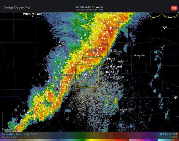
A Tornado Warning was issued for Ellis and Navarro counties until 3:45 pm CDT. There is potential for a rotation between Ennis, Texas, and Rice, Texas.

Tornado Warning including Ennis TX, Rice TX, Garrett TX until 3:45 PM CDT

See NWS Tornado's other Tweets
2:10 p.m. CDT Saturday:
The threat of tornadoes increases for Dallas-Forth Worth as a convective line approaches this afternoon.
There are more than 49,000 power outages in Texas due to the severe storms. Nebraska and Oklahoma are also experiences outages.
There are also multiple tornado warnings in effect across Arkansas.

Tornado Warning continues for Fort Smith AR, Alma AR, Barling AR until 2:30 PM CDT
See NWS Tornado's other Tweets
1:30 p.m. CDT Saturday:
Major street flooding has been reported across I-30 in Fort Worth, Texas. The Fort Worth Fire Department reported they are investigating a high water situation.
HIGH WATER INVESTIGATION | DISPATCHED: 13:29:36 | 3200 BLOCK GREENBELT RD (MAP 68A) | UNITS:E27 google.com/maps/place/FWF…


See Fort Worth Fire Department Incidents's other Tweets
1:12 p.m. CDT Saturday:
Dallas-Fort Worth Airport recorded a 62 mph wind gust this afternoon during the severe storms.

12:10 p.m. CDT Saturday:
Tornado warnings issued by the NWS are currently in effect for several locations across Oklahoma, including McAlester, Pryor and Salina through at least 12:45 p.m. CDT. Residents in affected areas should take cover immediately.

In Emporia, Kansas, an 86-mph thunderstorm-related wind gust was reported at 11:51 a.m. CDT.
Meanwhile in the Dallas area, severe storms continue to interrupt flights. Departing flights from Dallas/Fort Worth International Airport are experiencing gate hold and taxi delays of up to 1 hour and 14 minutes, while some flights due to arrive at the airport are being held up for an average of 2 hours and 37 minutes, according to the Federal Aviation Administration (FAA). Dallas Love Field Airport officials are not allowing departing flights to take to the skies until at or after 2 p.m. CDT.
Forty-eight minutes northwest of Dallas, emergency management reported dime-size hail in Little Elm, Texas, at 12:10 p.m. CDT.
11:40 a.m. CDT Saturday
Emergency management has reported a severe thunderstorm producing hail about 1 inch in diameter just east of Liberty, Oklahoma, at 11:24 CDT Saturday.
10:10 a.m. CDT Saturday
Law enforcement has reported street flooding in Silver Valley, Texas.
8:50 a.m. CDT Saturday
Around 8:42 a.m. CDT, a trained spotter reported a tornado on the ground in Silver Valley, Texas, which is east of Novice. The NWS confirmed it as rain-wrapped.
The Dallas-Fort Worth International Airport has already canceled 194 flights and delayed 67 others, according to FlightAware.

As thunderstorms approach #DFW, we remind you to check with your airline for any potential changes to your flight arrival or departure.
: DFW.to/flights


See DFW Airport's other Tweets
Meanwhile, emergency management near Lawton, Oklahoma, are reporting flooded roadways and water rescues.
8:10 a.m. CDT Saturday
The Storm Prediction Center confirmed that a tornado touched down in Geronimo, Oklahoma, damaging homes and trees. According to the report, the tornado may have begun as early as 7:35 a.m. CDT.
Around 7:30 a.m. CDT, trained spotters reported a house demolished off of FM2111 by Ballinger, Texas, with a possible injury and damage to a baseball stadium.
A trained spotter reported 60-mph wind gusts with a thunderstorm in Carnegie, Oklahoma, at 7.56 a.m. CDT.
There won’t be a siren test today. @okcoem is monitoring the #okwx situation and we’ll be ready for any emergencies. For storm prep tips, visit okc.gov/prepare. 7:58a 5/18/19

31 people are talking about this
7:00 a.m. CDT Saturday
At 6:29 CDT, the public reported hail measuring up to 1 inch in diameter in Elgin, Oklahoma.


5:50 a.m. CDT Saturday
A tornado-warned storm passed by the National Weather Service office located in San Angelo, Texas, just before 6 a.m. CDT. Another tornado-warned storm passed by Abilene, Texas around 5:50 a.m.
The Storm Prediction Center has not yet confirmed any tornadoes in these areas, but storm chasers caught video of a tornado near Ballinger, Texas.

NEW video of the tornado that occurred near Ballinger, Texas earlier this morning. Video from follower Lizette Paceley. #txwx #VortexCrew

344 people are talking about this


No comments:
Post a Comment