About 115 million people are in the path of severe weather that will sweep through the United States into the weekend. The storms are overlapping many of the regions impacted by the severe weather outbreak this past weekend, some of which are still recovering from the storm system's disastrous effects.
The outbreak is hitting areas across the southern U.S. as well as parts of the Midwest and Northeast from late Wednesday through Saturday.
A number of weather features, including large hail, tornadoes, strong winds and severe thunderstorms have been rattling the region. This storm is expected to continue to disrupt travel and commerce and may even disrupt Easter holiday plans.
Heavy rainfall can flood rivers and roadways, while strong winds and potential large tornadoes may damage homes and other buildings if they strike populated areas.

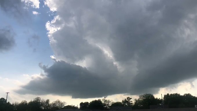
(Twitter photo/@TylerSorrells2)
Lightning illuminates an otherwise dark sky during the early morning hours of April 18, 2019, in Conway, Arkansas.

(Twitter photo/@michaeldean0116)
While it might appear that this image was taken during the day, Michael Dean Shelton captured it on April 18 at 3:46 a.m., local time, in Little Rock, Arkansas.

(Twitter photo/@BentonPoliceAR)
The Benton Police Department tweeted a view of the flooded intersection at Edison Ave. and Highway 35 on the morning of April 18. Police urge residents to avoid being out on the roads at all, if possible, and to avoid driving on flooded roads.

(Instagram photo/@vgo33me_atx)
A ball of lightning "exploded" and crackled in the sky over Cedar Park, Texas, early in the morning on April 18.

(Instagram photo/@stormguy8)
Brandon Munson captured this image of an overnight thunderstorm over Branson, Missouri, on April 18.

(Twitter photo/@TylerSorrells2)
Lightning illuminates an otherwise dark sky during the early morning hours of April 18, 2019, in Conway, Arkansas.

(Twitter photo/@LFMWx)
Accumulating hail accompanied by fog was seen on highway 273 south of McLean, Texas. Hail ranged mostly from as small as a pea to as big as a quarter.

(Twitter photo/@LFMWx)
Accumulating hail accompanied by fog was seen on highway 273 south of McLean, Texas.

(Twitter photo/@LFMWx)
Accumulating hail accompanied by fog was seen on highway 273 south of McLean, Texas.

(Twitter photo/@Reed Timmer)
AccuWeather Extreme Meteorologist Reed Timmer spotted a rotation north of Sunset, Texas.

(Photo/NOAA)
This NOAA satellite image shows the southern Plains on Wednesday, April 17, 2019 at around 3:30 p.m. local time.

(Twitter photo/@SherriVancampen)
A Texas resident tries to protect their car from hail.

(Twitter photo@/SherriVancampen)
A Texas resident tries to protect their car from hail.

(Twitter photo/@SherriVancampen)
A Texas resident tries to protect their car from hail.
The first of the powerful thunderstorms developed over the Texas Panhandle and central Iowa on Wednesday afternoon and became more widespread across northeastern Texas, eastern Oklahoma and western Arkansas as Wednesday night wore on.
RELATED:
2nd multi-day severe weather, tornado outbreak in a week looms for US
The difference between tornado watches and warnings
Preparing for severe weather: How to protect your car from thousands of dollars in hail damage
5 essential safety steps to take before severe weather hits
How to stay safe when severe weather strikes at night
As the storm system moves east, the severe threat will move into the South on Thursday from Louisiana to western Georgia and northward to Kentucky, southern Indiana and southern Illinois. Along with the thunderstorm threat, there will be the risk of tornadoes, flash flooding, strong wind gusts and travel disruptions in the region.

Download the free AccuWeather app to stay alert to severe weather watches and warnings. Keep checking back for updates on AccuWeather.com and stay tuned to the AccuWeather Network on DirecTV, Frontier and Verizon Fios.
Scroll down to follow live reports of the severe weather.
7:05 a.m. CDT Thursday:
Flooding has started to affect parts of Arkansas, where some areas including Little Rock had been under flash flood warnings since early Thursday morning. A portion of Highway 100 in North Little Rock is currently closed in both directions due to high water, according to KATV ABC 7.
Sheriff's deputies in Pulaski County, where Little Rock is located, are urging drivers to take caution driving Thursday morning. Pulaski County warned drivers via Twitter that some roads are currently barricaded for their safety.

The below Roads have flooded or have standing water on them from the overnight rain. The roads may still be a problem on your morning drive. Use caution on all roads this morning.

22 people are talking about this
The flooding has also prompted some school closures in Arkansas.
Meanwhile, the National Weather Service (NWS) office in Little Rock reported on Twitter that as of 7 a.m., local time, the North Little Rock Airport has picked up 2.91 inches of rain thus far, which breaks the daily rainfall record of 1.22 inches, set in 1977.

A current view of Edison and Hwy 35. Please avoid this area (and the others previously listed). Many schools have closed, and we recommend not being out and about if at all possible.#BNPD #FloodAlert #TurnAroundDontDrown

See Benton Police Dept.'s other Tweets
6:40 a.m. CDT Thursday:
Several public and private school closures and early dismissals have been announced ahead of severe weather expected to impact Louisiana Thursday, including in Jefferson, St. Tammany and Washington Parishes.
List: School closures in Southeast Louisiana due to severe weather wwltv.com/mobile/article…


See WWL-TV's other Tweets
4:40 a.m. CDT Thursday:
Thunderstorms now stretch from near Chicago to St. Louis, Little Rock, Shreveport, Houston and Corpus Christi. Despite frequent lightning, gusty winds and heavy downpours, most storms are no longer severe.
The morning commute across these areas will likely be slowed as travelers contend with flooded roadways, downed trees and powerlines, and power outages.
In Texas alone, over 110,000 customers are currently without power. Several thousand more are impacted across Missouri and Arkansas.
As the system moves eastward today, more severe weather is expected to develop.

1:50 a.m. CDT Thursday:
A line of powerful storms is currently sweeping through southern Missouri. While the threat for tornadoes has diminished, damaging winds and the threat of hail are still prevalent.
Golf ball-sized hail and snapped branches were left in the wake of these storms as they passed through Joplin. In the nearby town of Jasper, there were many reports of toppled power lines and over 1,000 power outages.

Lightning strike captured by Tyler Sorrells in Conway, Arkansas during the early morning hours of Apr. 18, 2019. via Twitter/TylerSorrells2
Farther south, wind gusts associated with these storms downed large trees across the Waco, Texas, area as well. As these storms traversed central Texas and moved through major population centers such as San Antonio, College Station and Dallas overnight, nearly 48,000 customers have been left without electricity.
10:58 p.m. CDT Wednesday:
The line of severe storms continues to sweep through Texas, Oklahoma, Kansas and into Missouri and Arkansas. Oklahoma County, Oklahoma, which is home to Oklahoma City, was walloped with quarter-sized hail around 10 p.m. local time.
Farther north in Pawnee County, thunderstorm wind gusts topped 60 mph.
1053p-Nickel size hail and 50 mph winds possible with strong storm near Blanchard in central OK moving E at 25 mph. #okwx

See NWS Norman's other Tweets
These threats will be prevalent through the night as storms continue to plow eastward.
9:15 p.m. CDT Wednesday:
Hail and 50-mph wind gusts are possible near Piedmont, Oklahoma.
There is also a report that a tornado touched ground near Shattuck, Oklahoma.
914p-Small hail and wind gusts to 50 mph possible with strong storm near Piedmont in central OK. Storm is moving NE at 45 mph.
See NWS Norman's other Tweets
8:00 p.m. CDT Wednesday:
Large hail has been spotted McLean, Texas, along with other areas across the south.
AccuWeather Extreme Meteorologist Reed Timmer reports an intense hail-producing supercell just east of Bowie, Texas.
7:30 p.m. CDT Wednesday:
A landspout tornado was sighted near Wellington, Kansas.
There are also many Severe Thunderstorm Warnings in effect across Kansas, Texas and Iowa.

Severe Thunderstorm Warning including Derby KS, Haysville KS, Goddard KS until 8:30 PM CDT

See NWS Severe Tstorm's other Tweets
6:30 p.m. CDT Wednesday:
There was a confirmed tornado near Higgins, Texas.
Storms continue to roll across Texas and parts of the southern U.S.
Towering cumulus about to develop into storms along dry line in north Texas. This is looking west from Valley View TX. @accuweather @breakingweather

46 people are talking about this
5:30 p.m. CDT Wednesday:
A funnel cloud was reported by the Amarillo Airport tower in Amarillo, Texas. Those in the tornado warning area should seek shelter now.

See NWS Amarillo's other Tweets
3:57 p.m. CDT Wednesday:
There is a report of a tornado near Glazier, Texas. The tornado tracked toward Coburn, Texas, where a tornado was also reported by a reliable spotter.
It is moving at 20 mph and has been described as a rope tornado.
3:05 p.m. CDT Wednesday:
There is accumulating hail accompanied by fog on Highway 273 south of McLean, Texas. Hail ranged mostly from as small as a pea to as large as a quarter.


Accumulating hail on highway 273 south of McLean on the Gray/Donley County line as of 3 PM. Hail ranged mostly from pea to pennies with a few nickels and quarters in there as well. Some nice #hail fog too! #phwx #TXwx @NWSAmarillo

31 people are talking about this
2:43 p.m. CDT Wednesday:
Southwest Airlines will suspend operations at Dallas Love Field Airport between 6 p.m. and 10 p.m. local time due to the severe weather forecast, canceling about 100 flights in and out, NBC DFW reports.
Severe weather will move into the Dallas-Fort Worth region late Wednesday afternoon into early night.
Dallas-Fort Worth residents are urged to prepare for the incoming threat of hail and severe weather.

Residents in DFW preparing for severe storms.

23 people are talking about this
1:45 p.m. CDT Wednesday:
Isolated showers and thunderstorms have reached west El Paso, Texas, according to NWS El Paso.
The storms will move eastward through the town over the next hour, bringing brief rainfall and the potential for pea-sized hail and gusty winds.
Light showers have also been reported in the Austin-San Antonio region in Texas.
A few showers have also developed across southeastern Oklahoma this afternoon, according to NWS Tulsa. These showers are well ahead of the severe thunderstorms that are expected to develop late afternoon and into the evening.
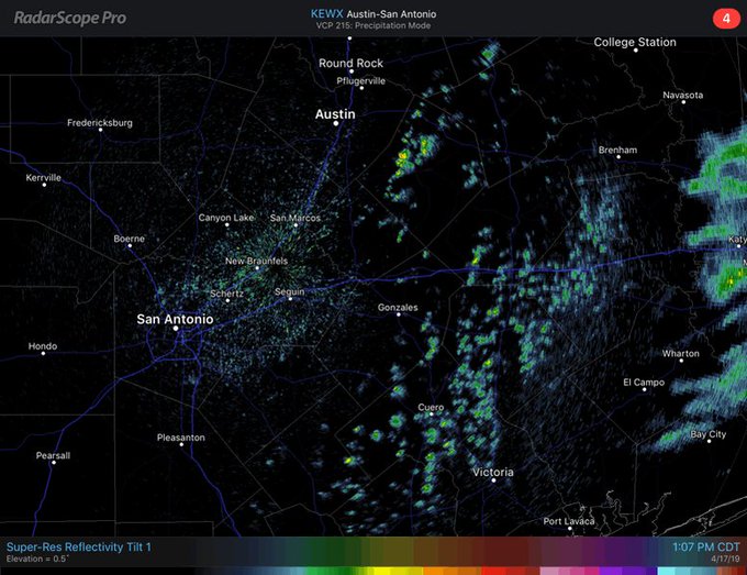

See NWS Austin/San Antonio's other Tweets
1:32 p.m. CDT Wednesday:
Severe thunderstorm watches and warnings are starting to be issued as the threat of the incoming storm grows.
A severe thunderstorm watch has been issued for the central and eastern portions of the panhandles in Texas, according to NWS Amarillo.
Another severe thunderstorm watch has been issued for parts of Oklahoma and Texas until 8 p.m. CDT.


30 people are talking about this
1:19 p.m. CDT Wednesday:
U.S. Vice President Mike Pence landed in Dallas, Texas, ahead of severe weather. While Pence is not in the region for weather-related issues, his trip may be interrupted by weather.
Dallas airports report disruptions due to the incoming extreme weather.
Over 200 flights have been canceled and 80 have been delayed at Dallas-Fort Worth International Airport, while over 100 flights have been canceled and 17 have been delayed at Dallas Love Field, according to FlightAware.com.
1:10 p.m. CDT Wednesday:
The National Weather Service issued a severe thunderstorm warning for several northern Texas towns until 2:30 p.m. CDT, including Howardwick, Ashtola and Goodnight.
There is a potential for wind gusts up to 60 mph and half-dollar-sized hail, according to the NWS office in Amarillo, Texas.
11:30 a.m. CDT Wednesday:
Emergency management officials in Illinois are urging residents to be prepared for strong to severe storms on Wednesday.
“The first line of defense against any emergency or hazard is personal preparedness,” said Acting IEMA Director Alicia Tate-Nadeau. “Take this time now to prepare your family for severe weather. Personal preparedness lessens the impact on families, workplaces and our communities.”
11:19 a.m. CDT Wednesday:
A few schools and universities around Dallas, Texas, announced closures due to the incoming severe weather.
Some schools announced that all after-school activities are canceled on Wednesday, including Garland ISD and Church at the Crossing, NBC5 Dallas-Fort Worth reports.
Collin College, a community college located north and northeast of Dallas, announced that it will close and classes after 1 p.m., local time, will be canceled on Wednesday due to the severe weather threat.
10:51 a.m. CDT Wednesday:
Various car dealerships in the Dallas-Fort Worth area are preparing for the potential hail and severe weather.
The different dealerships have unique strategies for combating the extreme weather impacts.


Different DFW car dealerships are getting ready for potential hail and bad storms later today...all in different ways. Here in Plano, Park Place Lexus is packing as many vehicles as possible inside the show room, with cardboard on ground to protect floor. @WBAP247NEWS @570KLIF

See Scott Sidway's other Tweets


No comments:
Post a Comment