Thursday, October 31, 2019

Snowstorm Prompts Closures of Colorado Schools, Government; I-70 Reopened East of Denver

Published: October 29, 2019


Travel officials announced Tuesday afternoon that a stretch of Interstate 70 east of Denver has been reopened after a snowstorm closed the roadway for hours.
Crashes and poor weather closed I-70 in both directions from Denver International Airport to Limon. The snowstorm, which was named Winter Storm Bessie by The Weather Channel, closed schools and government offices early in the Denver area.
Traffic struggles along the snow-packed southbound lanes of Interstate 25 near the Steele Street overpass as an autumn storm sweeps over the intermountain West Tuesday, Oct. 29, 2019 in Denver.
West of Denver, a jack-knifed semi temporarily closed the Eisenhower Tunnel.
Most schools held classes, but many districts in the Denver and Colorado Springs area said they were sending students home early in anticipation of heavier snowfall later in the day. The Colorado Department of Transportation urged people in the Denver area to leave work early for the same reason.
Government offices were closed at 2 p.m. due to the impending weather.
More than 900 flights have been delayed or canceled into or out of Denver International Airport, as of Tuesday afternoon. The airport has seen around 6 inches of snow so far.
Riders on bus and light rail in Denver were delayed by 30 minutes, Tuesday morning due to the weather conditions and lack of drivers, according to CBS Denver.
The frigid weather that came along with the snow set new record lows Tuesday, including a reading of minus 2 near Craig in northwestern Colorado.
The Weather Company’s primary journalistic mission is to report on breaking weather news, the environment and the importance of science to our lives. This story does not necessarily represent the position of our parent company, IBM.

The Weather Company’s primary journalistic mission is to report on breaking weather news, the environment and the importance of science to our lives. This story does not necessarily represent the position of our parent company, IBM.

Tens of Millions Could Be Hit by Sea Level Rise Sooner Than Thought, New Study Suggests

Bob HensonPublished: October 29, 2019


A new analysis of coastlines around the world indicates that sea level rise linked to climate change could lead to annual flooding – and eventually to daily inundations at high tide – more quickly than thought. More than 200 million people may be affected globally as soon as 2050, several times more than previously estimated, the study finds.
While the new study is not the last word on sea level rise, it highlights a persistent underestimation of the vulnerability of many coastlines, according to authors Scott Kulp and Benjamin Strauss of the independent research center Climate Central. The study was published Tuesday in Nature Communications.
“As the tideline rises higher than the ground people call home, nations will increasingly confront questions about whether, how much, and how long coastal defenses can protect them,” said Kulp in a news release. “These assessments show the potential of climate change to reshape cities, economies, coastlines, and entire global regions within our lifetimes.”
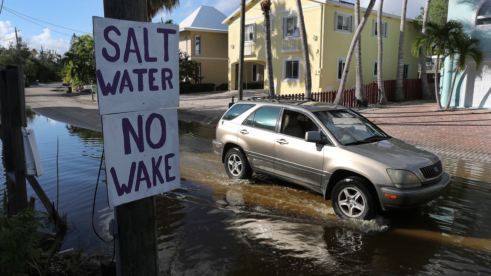
A car drives down a flooded street on Oct. 22, 2019, in Key Largo, Florida. King-tide level waters combined with earlier storms and other factors has forced water onto the streets in parts of the Florida Keys, which will likely see increased flooding as sea levels continue to rise.
Coastal vulnerability is well assessed in the United States, where high-resolution data is widely available. The new findings confirm earlier work by Climate Central showing that U.S. vulnerability will increase this century as sea level continues to rise. NOAA estimates that the national average of five high-tide flood days per year – about twice as much as 20 years ago – might reach 7 to 15 days by 2030 and 25 to 75 days by 2050, with the largest increases along the Gulf and Atlantic coasts.
The new paper shows that coastline vulnerability may be greatly underestimated in developing nations, where high-resolution data is unavailable or sparse.
The study finds that roughly 190 million people currently occupy global land that could be inundated by regular high tides (mean higher high water) by 2100, even if greenhouse gas emissions peak by midcentury. This compares to an estimate of 110 million people from a widely used NASA model.
Under the same scenario, less-frequent annual flooding could affect much more territory as soon as 2050, including land where some 237 million people live today within six Asian countries (China, Bangladesh, India, Vietnam, Indonesia, and Thailand). This compares to earlier estimates of only about 50 million people.
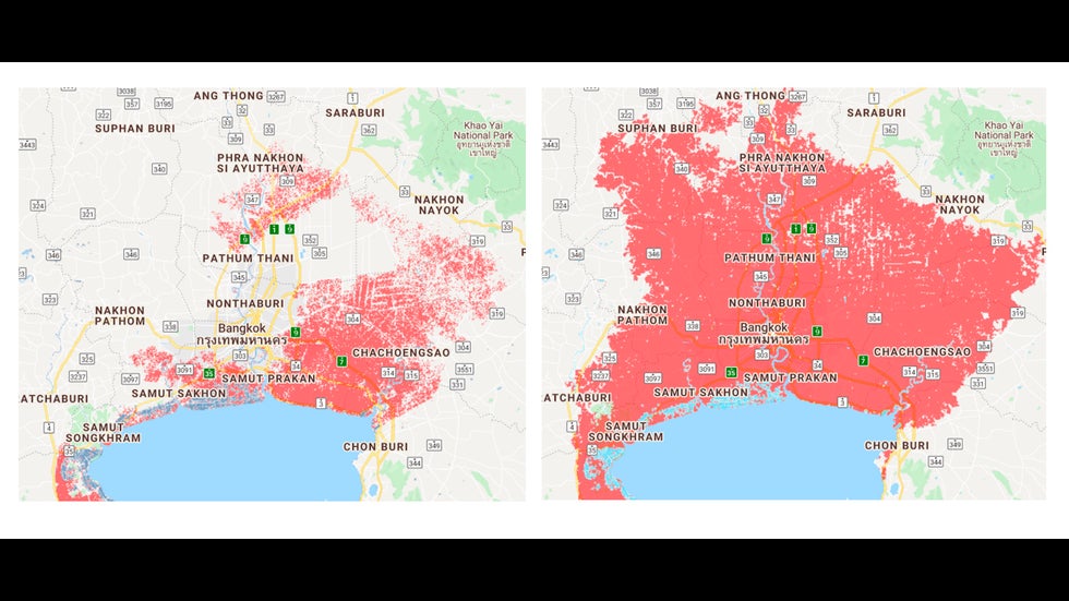
Improved elevation data from CoastalDEM significantly expands the area around Bangkok, Thailand (in red) expected to experience, on average, once-a-year coastal flooding by 2050.
If emissions keep rising through the century, regular high-tide flooding could occur by 2100 on coastal land where 250 million people now live in those six countries.
Even if greenhouse emissions are cut drastically, more than 20 other nations could see regular high tides by 2100 over land where at least 10% of their population is now located, the study finds.

Getting a Better Bead on Coastal Elevation

The new findings are based on output from CoastalDEM, a digital elevation model (DEM) developed by Climate Central. Because sea level cannot be directly measured with instruments along every inch of coastline, DEMs are used to produce regional and global estimates of which coastlines are most vulnerable to sea level rise.
One of the most commonly used DEMs for international assessment of coastal flood risks is NASA’s satellite-based Shuttle Radar Topography Mission (SRTM). Like most of its counterparts, the SRTM tends to overestimate the height of topography near coastlines, because it detects objects such as trees or buildings that extend higher than the coastline itself. As a result, the impacts of sea level rise can be underestimated.
“Some studies have properly handled the vertical uncertainty,” said Dean Gesch (U.S. Geological Survey) in a 2018 paper on best practices for DEM use. “However, many other studies ignore the vertical uncertainty stemming from the underlying elevation data.”
The CoastalDEM model uses neural networks – a form of machine learning that allows software to make continuous improvements over time – in order to reduce systemic errors in the SRTM data. The model was “trained” on a subset of U.S. coastal locations where dense, high-resolution data was available. It was then tested on other U.S. and Australia locations before being extended to other parts of the world.
According to Climate Central, CoastalDEM reduces the typical coastal elevation error to an average of about 4 inches, compared to 6 feet or more in SRTM.
To calculate vulnerability, the CoastalDEM model output was combined with previous estimates of expected sea level rise, including both lower- and higher-end estimates. The lower scenario assumes that greenhouse emissions will level off by 2040 and then decline (the IPCC’s RCP4.5 scenario).
The higher scenario assumes more rapid emissions increases through the century (RCP8.5), together with the possibility that instabilities within Antarctic coastal ice cliffs could lead to rapid sea level rise later this century, as past research has suggested.
Melissa Moulton, a scientist at the National Center for Atmospheric Research who specializes in coastal oceanography and remote sensing, said in an email that the new findings are a valuable contribution to better assessing impacts of sea level rise.
“These estimates are an important indicator of the threat to our coastal populations,” said Moulton. She noted that actual inundation at any one spot will also depend on how land use changes and on the small-scale hydrologic and geologic evolution of the coastline, factors that are not considered in this study.
“I think this is a very interesting study to assess uncertainties in projecting the impacted population by rising sea level,” said Aixue Hu, a climate researcher at NCAR. “It gives us another angle to look at this problem.”
Hu points out that a number of uncertainties remain, as called out by the researchers themselves. According to Hu, “the results also suggest that better coverage of DEM observations could potentially further reduce the uncertainty.”
A far more precise technique than using DEMs is to carry out fine-scale elevation measurements using airborne lidar (laser-based radar). Such lidar-based data has not yet been collected along many coastlines around the world, but it is available for U.S. coastlines. Using publicly available lidar-based data, Climate Central has published high-resolution risk zone maps for U.S. coastal locations.
The study estimates that some 900,000 U.S. residents are in locations that would be flooded regularly by high tide were it not for levees and other protections.
The authors found that even the CoastalDEM data consistently underestimated the coastal vulnerability in the United States when compared with the finer-scale lidar-based U.S. data.
“Ultimately, the most accurate assessments of vulnerability to rising seas, especially for smaller areas, will require development and public release of improved coastal area elevation datasets building directly off of new high resolution observations increasingly collected by satellites today,” the authors conclude.
The Weather Company’s primary journalistic mission is to report on breaking weather news, the environment and the importance of science to our lives. This story does not necessarily represent the position of our parent company, IBM.

The Weather Company’s primary journalistic mission is to report on breaking weather news, the environment and the importance of science to our lives. This story does not necessarily represent the position of our parent company, IBM.


Northern Westchester Freeze Watch Freeze Watch in effect from Saturday, 12:00 AM EDT until Saturday, 10:00 AM EDT. Source: U.S. National Weather Service

...FREEZE WATCH IN EFFECT FROM LATE FRIDAY NIGHT THROUGH SATURDAY MORNING... The National Weather Service in Upton has issued a Freeze Watch, which is in effect from late Friday night through Saturday morning. * TEMPERATURES...As low as the upper 20s. * TIMING...Late Friday night into early Saturday morning. * IMPACTS...Below freezing temperatures could kill crops and other sensitive vegetation. PRECAUTIONARY/PREPAREDNESS ACTIONS... A Freeze Watch means below freezing temperatures are possible. These conditions could kill crops and other sensitive vegetation.

Halloween snowstorm wallops the Midwest

Updated Oct. 31, 2019 9:21 AM


A winterlike storm continued to unload snow over the Midwest on Thursday, making Halloween feel more like Christmas in many areas.
The same storm system that brought snow and cold to the Rockies earlier this week tracked across the central United States into early Thursday morning, unleashing heavy snowfall, fierce winds and brutal cold. Moderate to heavy snowfall will occur from eastern Iowa, northeastern Kansas, Illinois and southern Wisconsin as the storm strengthens throughout the day Thursday.
Up to 5 inches of snowfall has already buried parts of Iowa on Thursday morning, leaving roads in central and eastern parts of the state snow-covered and slick, according to the Iowa Department of Transportation (Iowa DOT).
Eastern and southeastern Iowa were looking wintry on Thursday morning, Oct. 31, 2019. (Iowa DOT)
More than 240 plows were out in force across eastern and southeastern Iowa on Thursday morning as snow thumped across the area, Iowa DOT tweeted. However, officials cautioned that roads may still be slippery and people should "buckle up, slow down and allow extra space between vehicles."
On Wednesday, Chicago experienced its earliest snow day in the season where an inch or more fell since Oct. 20, 1989. It was also only the 10th inch-plus snow day to occur so early in the season, according to the National Weather Service (NWS) office in Chicago. A record snowfall of 1.2 inches was recorded at Chicago O'Hare International Airport on Wednesday, breaking the old record of 0.7 of an inch set way back in 1923.
Meanwhile, much colder air will rush in as the storm evolves. Temperatures near freezing will allow an area of rain to mix with and change over to snow.
"This transition will take place in northern and central locations of the Lower Peninsula of Michigan into this afternoon," Ryan Adamson, AccuWeather meteorologist, said.
Snow will continue into Thursday evening across Michigan.
Snowfall from eastern Iowa and southern Wisconsin to northern Michigan will accumulate 3 to 6 inches. The AccuWeather Local StormMax™ is 14 inches.
Where snowfall rates will be generally be light, accumulation may not occur on roads initially. As the storm intensifies into Thursday night, snow-covered roads are expected to result in slippery travel conditions and delays. In areas where this is the first snowfall of the year, snow may stick to roads quicker where a layer of salt hasn't developed yet.
Wet snow can stick to trees and power lines and weigh them down. Any areas that still have many leaves on the trees will be more susceptible to damage. However, a significant windstorm will also accompany this system, which will help to knock many leaves off the trees.
RELATED:
As the storm continues to wrap up and shift to the northeast, snow will continue to shift eastward.
"By this evening, much of Lower Michigan will see snow, and snow will also fall in northern Indiana and northern Ohio," continued Adamson. "The exceptions may be right along the shores of the Great Lakes, as a mix of rain and snow or even just rain may fall, since the lakes are still warm."
Through the rest of the night, snow will gradually come to an end in southern Wisconsin and northern Illinois.
While snow is expected to fall across northern Indiana and Ohio, accumulations are forecast to be minimal as the storm will begin to race away to the northeast through late in the night.
Snow is expected to end quickly across Michigan on Friday morning as the storm continues to pick up speed. However, another blast of snow and cold is expected to target the Great Lakes this weekend.

2nd deadly earthquake in 3 days causes damage in southern Philippines

Updated Oct. 31, 2019 8:52 AM


On the island of Mindanao, one of the southernmost islands of the Philippines, communities have felt the effects of two powerful earthquakes rated over 6.0 magnitude in the past three days.
Mid-morning, local time, on Oct. 31, a powerful earthquake struck one kilometer south of Kisante, Philippines. According to the United States Geological Survey (USGS) and the Philippine Institute of Volcanology and Seismology (Phivolcs), this earthquake registered as a 6.5 on the Richter Scale.
According to the Pacific Tsunami Warning Center, there was no tsunami threat with the quake.
The earthquake was strong enough to cause major structural damage across places like Davao City and Kidapawan City.
At least five people were killed in Thursday's earthquake, according to the Associated Press. This news comes after at least eight people were killed, and nearly 400 people were injured, in Tuesday's 6.6 magnitude earthquake.
Eva's Hotel stands damaged after a strong earthquake in Kidapawan, north Cotabato province, Philippines, Thursday, Oct. 31, 2019. The third strong earthquake this month jolted the southern Philippines on Thursday morning, further damaging structures already weakened by the earlier shaking. (AP Photos/Williamor Magbanua)
The Eva Hotel took on some damage during Tuesday's quake. However, the lobby collapsed in Thursday's earthquake while six employees and and an engineer were inside inspecting the initial damage. All seven people were able to escape the building.
The back-to-back earthquakes are being attributed to even more widespread damage. Some structures, weakened by the Tuesday earthquake, were more susceptible to tumbling down in Thursday's powerful quake.
RELATED:
According to Reuters, Phivolcs is advising that residents remain outside of their homes. The fear is that unstable or partially damaged homes and offices could tumble in an aftershock, even if it's less powerful.
This as left hundreds of people displaced, living in tents out in the tropical conditions.
According to CNN Philippines, all private and public schools in Davao City have been suspended through Nov. 4. Several other cities and towns hit hard by the quake were suspending schools and office work.
Not only is Thursday's earthquake the second of two major quakes in just three days, but also the third 6.0 magnitude or greater earthquake in 15 days. The first major earthquake of October took place on Oct. 16 and had a magnitude of 6.3, killing at least seven people.

Hillside Fire threatens neighborhoods in San Bernardino prompting officials to order evacuations

Updated Oct. 31, 2019 8:55 AM


Santa Ana winds are forecast to continue into Thursday across Southern California, but the fire danger will not end as winds begin to gradually lessen.
A new brush fire in San Bernardino, named the Hillside Fire, ignited on Thursday morning and quickly grew in severity. Just one day after the Easy Fire drew widespread concern, this second, fast-growing wildfire quickly forced evacuations.
According to a tweet posted by the San Bernardino National Forest, the blaze “has entered neighborhoods in north San Bernardino. Mandatory evacuations are in effect west of Hwy 18, which has been closed.”
Video posted to social media showed firefighters battling the raging fires in a neighborhood that had been turned into a hellish landscape, with numerous homes on fire and smoke and embers filling the dark sky all while powerful winds whipped through the area.
The San Bernardino County Fire Department (SBCFD) first responded to the blaze at 2:10 a.m., local time, and found three acre of fire. By 4:40 a.m., over 300 firefighting personnel were on the scene.
The Easy Fire, located in Simi Valley, has been anything but easy for crews to handle. After sparking early Wednesday morning near Easy Street, hence the name, the blaze rapidly grew from just 200 acres to more than 1,600 acres by Wednesday evening. As of 4 a.m. PDT Thursday, the fire was at 0% containment, according to Ventura County Office of Emergency Services. However, Cal Fire reports that at least 5% of the blaze has been contained.
The fire ignited near the 118 Freeway and Madera Road and quickly spread toward neighborhoods, forcing officials to enact widespread mandatory evacuations. According to Ventura County Fire Captain Steve Kaufmann, 7,000 homes were threatened by the blaze on Wednesday.
Evacuations also included the Ronald Reagan Presidential Library, which is the largest presidential library in the nation. Reports say the library brings hundreds of goats every May to eat the brush around the perimeter of the building to create a fire break, which could have saved the library from the Easy Fire's flames.
Shortly after 3 p.m. PDT, California Highway Patrol announced flames jumped the 23 Freeway just north of Tierra Rejada Road. At least 800 firefighters are battling the Easy Fire, which is approximately 50 miles northwest of downtown Los Angeles.
Strong winds were reported in the area near the Easy Fire, including a 78 mph gust at Boney Mountain. A gust of that force is equivalent to the wind strength of a Category 1 hurricane.
The blaze initially spread toward and threatened the Ronald Reagan Presidential Library, coming dangerously close to the building. According to a representative from the library, a flock of goats "is what saved us today." Each year, the library brings in about 300 goats to eat flammable vegetation around the building.
On Wednesday, California Gov. Gavin Newsom announced that the state has secured a Fire Management Assistance Grant to help ensure the availability of resources to fight the Easy Fire burning in Ventura County.
“The continued real-time assistance provided as California grapples with fires across the state has been critical to our efforts to keep communities safe and reduce damages,” said Newsom. “We are thankful to our federal, state and local partners for their extraordinary, collaborative response in this challenging time.”
A similar preventative measure may have also spared the Getty Center in Los Angeles from the destructive Getty Fire. While the blaze hasn't grown as fast as the Easy Fire or nearly as massive as the Kincade Fire, it has threatened one of the most populous regions in the country. Since igniting on Monday morning, the inferno has threatened the Brentwood and Westside communities in Los Angeles.
On Tuesday, Los Angeles Mayor Eric Garcetti told reporters that the cause for the ignition of the blaze was wind blowing dried branches onto power lines.
A civilian vehicle traveling on the Sepulveda Pass caught the initial flash on a dashcam.
According to Los Angeles Fire Department (LAFD) Public Information Officer Erik Scott, "There is no evidence of arson or an intentionally set fire and there is no evidence of a homeless encampment in the fire's area of origin."
According to the LAFD, 12 structures have been destroyed by the Getty Fire and the blaze was at 27% containment as of early Wednesday. More than 7,000 residences are in the Mandatory Evacuation Zone and should be considered threatened.
"Overnight, crews and aircraft worked to contain wind-driven spot fires and flare-ups within the current fire perimeter," LAFD said in a Wednesday morning statement. "Adverse weather conditions will be the biggest challenge for firefighters today. An Extreme Red Flag Warning remains in effect throughout the day today and into tomorrow."
Meanwhile, California's largest fire of the year, the Kincade Fire, continues to wreak havoc in Northern California. Since igniting last week in Sonoma County, the blaze has spread to 76,825 acres and is at 45% containment according to Cal Fire.
The massive fire has destroyed 266 structures, including a historic winery, as more than 5,000 personnel assigned to the blaze have struggled against strong winds. Since the Kincade Fire began, nearly 200,000 people have been forced from their homes.
Hundreds of thousands of residents have had to deal with power shutoffs from Pacific Gas & Electric (PG&E). Starting on Oct. 26, more than 900,000 customers had their power shut off for safety purposes. While 57% of those customers had power restored by Monday, another 605,000 customers had their power cut on Tuesday.
RELATED:

Man missing at sea for nearly 2 weeks found alive in life raft off Washington coast

  One of two men missing at sea for nearly two weeks was found alive on Thursday by a Canadian fishing boat in a life raft in Canadian water...