Thursday, May 7, 2020

The U.S. Is Having One of Its Deadliest Tornado Years in a Decade

Chris Dolce
Published: April 27, 2020


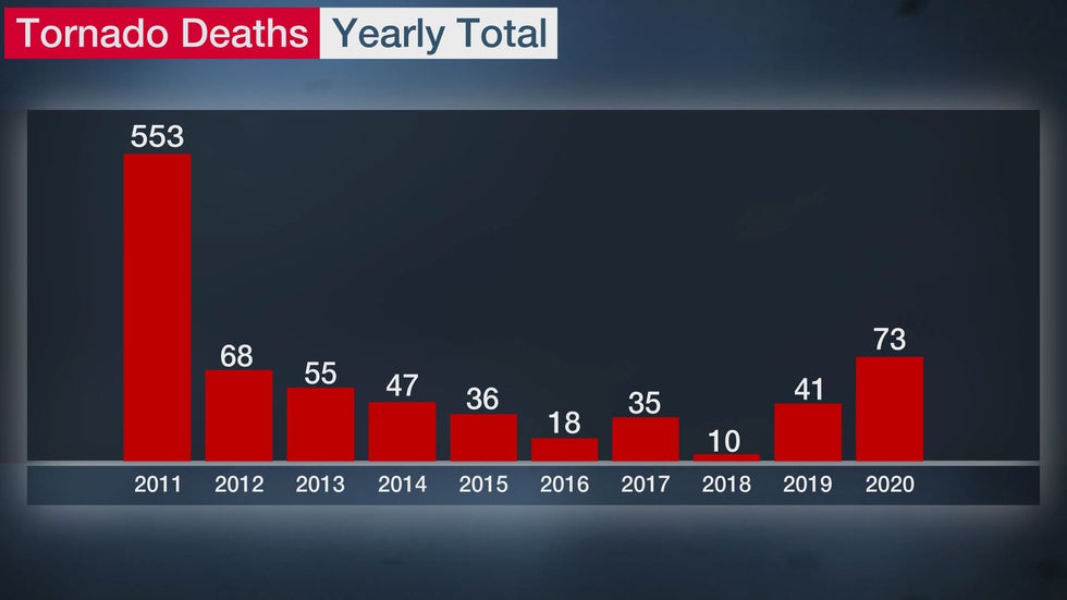
A series of severe weather outbreaks in April have more than doubled the United States tornado death toll in 2020, making it the deadliest year of twisters in nine years.

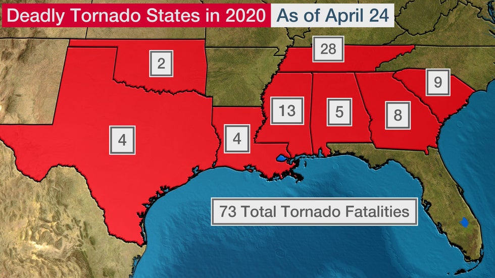
Tornadoes in 2020 have claimed 73 lives as of April 24, according to NOAA's Storm Prediction Center. Those have all occurred in eight southern states, with Tennessee and Mississippi having the most.

The number of tornado-related fatalities in each state so far this year.

This year's toll surpasses anything we've seen since the horrible 2011 tornado year, when 553 lives were lost.

Tornadoes, on average, have killed 69 people per year from 1989 to 2018, according to NOAA. But that average is skewed somewhat high because of 2011.

Since 1980, the yearly death toll from tornadoes exceeded 70 just seven other times.

Before April 12, there were already 33 deaths related to tornadoes in the U.S. The majority of those were in Tennessee on March 2 and 3, when 25 lives were lost, including 19 who perished in an EF4 twister that struck near Cookeville.

That toll skyrocketed by 40 in an 11-day period from April 12 through 22, mostly because of a major tornado outbreak in the South Easter Sunday into the following Monday morning.

One reason this year has been so deadly is that there have been a number of strong tornadoes, which account for a larger number of tornado fatalities. Nearly 95% of tornado deaths from 2000 to 2019 were from strong (EF2/EF3) or violent tornadoes (EF4/EF5).

Violent (EF4 or EF5) tornadoes were responsible for half the tornado-related deaths in the U.S. from 2000 to 2019.

All but four of this year's 73 deaths have been from tornadoes rated EF2 to EF4. There have been no EF5 tornadoes so far this year.

Another factor in this year's loss of life is that some of the deadly twisters struck at night. Tornadoes occurring at night are more than twice as likely to be deadly as those during the day, according to a study.

When severe weather threatens, make sure you have multiple ways to receive warning information. This could include a NOAA weather radio, smartphone or television. Check this link for additional tips on what you can do to stay safe.

The Weather Company’s primary journalistic mission is to report on breaking weather news, the environment and the importance of science to our lives. This story does not necessarily represent the position of our parent company, IBM.

The Weather Company’s primary journalistic mission is to report on breaking weather news, the environment and the importance of science to our lives. This story does not necessarily represent the position of our parent company, IBM.

This Date in Weather History for May 7,2020

Weather History
For Thursday,May 7,2020


1840 - A powerful tornado wrecked many boats at the Natchez Landing in Mississippi, then plowed through the city on the bluff. The tornado killed 317 persons, and caused a million dollars damage. The force of the storm caused houses to burst open. The tornado was the most deadly and destructive in early American history. (David Ludlum)
1964 - The temperature at White Mountain 2, located in California, dipped to 15 degrees below zero to set a record for May for the continental U.S. (The Weather Channel)
1987 - Thirty-one cities in the western U.S. reported record high temperatures for the date. Highs of 93 degrees at Portland OR and San Jose CA were the warmest of record for so early in the season. The high of 92 degrees at Quillayute WA was a record for the month of May. The temperature at Sacramento CA hit 105 degrees. (The National Weather Summary)
1988 - A powerful storm in the north central U.S. produced up to three feet of snow in the Bighorn Mountains of Wyoming and the mountains of south central Montana. Up to five inches of rain drenched central Montana in less than 24 hours, and flash flooding in Wyoming caused a million dollars damage. (Storm Data) (The National Weather Summary)
1989 - Thirty-two cities in the central and eastern U.S. reported record low temperatures for the date, and 24 hour snowfall totals of 7.2 inches at Buffalo NY and 10.7 inches at Rochester NY were records for the month of May. While northerly winds ushered unseasonably cold air into the eastern U.S., temperatures warmed rapidly in the Great Plains Region, reaching the 90s in Kansas. The temperature at Manhattan KS soared from a low of 30 degrees to a high of 88 degrees. (The National Weather Summary) (Storm Data)
1990 - Gale force winds lashed the northern and central Pacific coast. A wind gust of 52 mph at Eureka CA established a record for the month of May. Strong winds over northeastern Colorado, associated with a fast moving Pacific cold front, gusted to 63 mph at Peetz. Snow developed over the northwest mountains of Wyoming late in the day, and Yellowstone National Park was whitened with 6 to 14 inches. (The National Weather Summary) (Storm Data)

This Date in Weather History for May 6,2020

Weather History
For Wednesday,May 6,2020


1933 - Charleston, SC, was deluged with 10.57 inches of rain, an all- time 24 hour record for that location. (The Weather Channel)
1975 - A massive tornado hit Omaha, NE, killing three persons, injuring 133 others, and causing 150 million dollars damage. The tornado struck during the late afternoon moving northeastward through the industrial and residential areas of west central Omaha, and lifting over the northern section of the city. The twister, which cut a swath ten miles long and as much as a quarter of a mile wide, was the mostly costly in U.S. history up til that time. (David Ludlum)
1987 - Eighteen cities in California and Oregon reported record high temperatures for the date. Highs of 91 degrees at Portland OR, 101 degrees at Medford OR, and 104 degrees at Sacramento CA, were the warmest of record for so early in the season. (The National Weather Summary)
1988 - A major storm brought high winds to the western half of the country. A wind gust of 74 mph at Pueblo CO broke their May record established just four days earlier, and winds in the Arapahoe Ski Basin area of Colorado reached 85 mph. In North Dakota, the high winds reduced visibilities to near zero in blowing dust closing many roads. (The National Weather Summary) (Storm Data)
1989 - Sixteen cities in the north central U.S. reported record low temperatures for the date. Morning lows of 17 at Bismarck ND and 26 at Minneapolis MN were the coldest of record for so late in the season. A reading of 43 degrees at the start of the Kentucky Derby was the coldest in 115 years of records. Light snow was reported in the Upper Midwest, with an inch reported at Chicago IL. (The National Weather Summary)
1990 - Snow and high winds prevailed behind a Pacific cold front crossing the northwestern U.S. Wind gusts above 50 mph were reported in southeastern Idaho, and heavy snow blanketed the Cascade Mountains of Washington State, with twelve inches reported at Stampede Pass. (The National Weather Summary)

This Date in Weather History for May 5,2020

Weather History
For Tuesday,May 5,2020


1917 - The same storm which a day earlier produced eight inches of snow in the Texas panhandle, produced a foot of snow at Denver CO, their heaviest snow of record for the month of May. (David Ludlum)
1930 - The temperature at College Park, VA, soared from 43 degrees to 93 degrees to begin an exceptional heat wave. (Sandra and TI Richard Sanders - 1987)
1987 - Unseasonably hot weather prevailed in the western U.S. A dozen cities in California reported record high temperatures for the date. Afternoon highs of 93 degrees at San Francisco, 98 degrees at San Jose, 100 degrees at Sacramento, and 101 degrees at Redding, were the warmest of record for so early in the season. The high of 94 degrees at Medford OR was also the warmest of record for so early in the season. (The National Weather Summary)
1987 - Parts of the western U.S. were in the midst of a blistering May heat wave. The reading of 100 degrees in Downtown Sacramento CA was their earliest of record. Sacramento CA established daily record highs on nine of eleven days between the 4th and the 14th. (The Weather Channel)
1988 - A stubborn low pressure system continued to drench the eastern U.S. with rain. Thunderstorms again produced large hail in North Carolina. (The National Weather Summary)
1989 - Thunderstorms swept across Georgia and the Carolinas during the late afternoon and evening hours spawning seventeen tornadoes. A tornado at Toccoa GA injured 15 persons, and a tornado at Chesnee SC killed two persons and injured 35 others. Five tornadoes in North Carolina accounted for five deaths, 88 injuries, and sixty million dollars damage. Thunderstorms also produced baseball size hail at Lake Murray SC, and wind gusts to 78 mph at Brooklyn MD. (The National Weather Summary) (Storm Data)
1990 - A strong Pacific cold front moving rapidly inland caused weather conditions at the east end of the Strait of Juan de Fuca in Washington State to quickly change from sunny and calm to westerly winds of 60 mph and ten-foot waves. Three recreational fishing boats capsized in heavy seas off Port Angeles resulting in five deaths. In California, temperatures soared above 90 degrees across much of the state. The high of 101 degrees in downtown Los Angeles was eight degrees hotter than their previous record for the date. (The National Weather Summary) (Storm Data)

This Date in Weather History for May 4,2020

Weather History
For Monday,May 4,2020


1812 - A storm produced snow from Philadelphia to Maine. A foot of snow fell near Keene NH, and in Massachusetts, nine inches fell at Waltham, located near Boston. (David Ludlum)
1917 - A late season snowstorm in northwest Texas produced up to eight inches of snow in Potter County and Armstrong County. (David Ludlum)
1922 - Austin, TX, was hit twice by tornadoes which struck within thirty minutes of each other. Twelve persons were killed in the tornadoes. (The Weather Channel)
1977 - A tornado 500 yards in width struck Pleasant Hill, MO, severely damaging the high school and grade school. Only minor injuries were reported among the more than 1000 teaches and students due to excellent warnings and prior tornado drills. (The Weather Channel)
1987 - Thunderstorms produced severe weather in the southeastern U.S., with South Carolina hardest hit. Thunderstorm winds toppled trees seventy feet high in Spartanburg County SC, and knocked homes off their foundations near Bishopville SC. (Storm Data) (The National Weather Summary)
1988 - Thunderstorms produced large hail in North Carolina, but brought welcome rains to much of the rest of the eastern U.S. Residents of New England finally saw sunshine after about a week of clouds and rain. (The National Weather Summary) (Storm Data)
1989 - Thunderstorms produced severe weather in the Southern Plains Region and the Lower Mississippi Valley. Thunderstorms spawned fifteen tornadoes, and there were 340 reports of large hail and damaging winds. Hail three inches in diameter, and 9.39 inches of rain, resulted in more than 130 million dollars damage at Monroe LA. Thunderstorm winds gusted to 100 mph at Epps LA and Fort Worth TX. A thunderstorm north of Mineral Wells TX produced high winds which unroofed a nightclub, turning it into a "topless club." (The National Weather Summary) (Storm Data)
1990 - Thunderstorms produced severe weather from the Lower Ohio Valley to Virginia and the Carolinas. A tornado at Augusta Springs VA killed two people and injured ten others, and another tornado caused 1.7 million dollars damage at Colonial Heights VA. Temp-eratures soared into the 90s in northern California. The high of 98 degrees in downtown Sacramento was their hottest reading of record for so early in the season. (The National Weather Summary) (Storm Data)

Sunday, May 3, 2020

New York City metro-area forecast for May 3-June 7,2020

Here's the 5-week weather forecast for the New York City metro-area for the period of May 3-June 7,2020 from accuweather.com


Today,May 3: Becoming very warm with times of clouds and sunshine and a high temperature of around 80 degrees.As of 1:30PM,EDT,it's 76 degrees and mostly cloudy,with 52% humidity making it feel like it's 84 degrees,in White Plains,NY and it's 72 degrees and mostly cloudy,with 52% humidity making it feel like it's 80 degrees,in New York City.

Tonight: Becoming cloudy this evening and partly cloudy overnight with a low temperature dropping to the middle 50's,overnight.

Tomorrow,May 4: Not as warm with times of clouds and sun then turning breezy with a chance for some spotty afternoon rain showers possible and a high temperature in the middle 60's.

Tomorrow night: Becoming partly cloudy and colder than recent nights,with a low temperature dropping to 40-45 degrees,overnight.

Tuesday,May 5: Becoming partly sunny and a bit cool for early May,with a high temperature only in the upper 50's to lower 60's.Remaining partly cloudy and chilly for early May with a low temperature dropping to the upper 30's to lower 40's,overnight.

Wednesday,May 6: Remaining mostly cloudy,raw and cool for early May and mid-spring with a passing afternoon rain shower and a high temperature only in the upper 50's to lower 60's,once again.Becoming partly cloudy and seasonably mild with a low temperature dropping to the middle 40's,overnight.

Thursday,May 7: Remaining rainy,raw and a bit cool for early May with a mix of clouds and sunshine and a high temperature of 60-65 degrees.Remaining partly cloudy and cool with a low temperature dropping to 40-45 degrees,overnight.

Friday,May 8: Becoming mostly cloudy with a high temperature in the upper 50's to lower 60's.Becoming cloudy,rainy,unseasonably cold and possibly wintry with occasional rain and drizzle changing to snow in higher elevations and normally colder locations and a record,or near record low temperature plunging to the lower and middle 30's,the southwesterly winds making it feel downright frigid for early May,like it's only 20-25 degrees above zero,at times,overnight.

Saturday,May 9: Remaining mostly cloudy and rainy,but turning unseasonably raw and cool for early May and mid-spring with a chance for morning rain followed by leftover showers and a high temperature only in the lower and middle 50's.Becoming mainly clear and not as cold with a low temperature dropping to around 40 degrees,overnight.

Sunday,May 10: Mother's Day 2020 will be remaining mostly cloudy and unseasonably cool for mid-spring,with a high temperature of just 55-60 degrees.Becoming mainly clear,but remaining unseasonably cold for early May,with a low temperature dropping to around 40 degrees,once again,the westerly winds,which could gust up to 30-mph,at times,making it feel even colder,like it's only 30-35 degrees,at times,overnight.

Monday,May 11: Remaining mainly cloudy,raw and cool with a high temperature of just 55-60 degrees,once again.Becoming clear to partly cloudy,but remaining unseasonably cold with a record,or near record low temperature dropping to 35-40 degrees,overnight.

Tuesday,May 12: Remaining unseasonably cool for mid-to-late spring with a mix of sunshine and clouds and a high temperature,for the third straight day,of just 55-60 degrees.Remaining unseasonably cold with a chance for a stray late-night rain shower and a record,or near record low temperature dropping to around 40 degrees,overnight.

Wednesday,May 13: Becoming cloudy,but remaining unseasonably cool for early-to-mid May,with a high temperature only in the upper 50's to lower 60's.Remaining cloudy and rather cold for mid-to-late spring with a low temperature dropping to the upper 30's to lower 40's,overnight.

Thursday,May 14: Becoming partly sunny and milder than recent days,with a high temperature of 60-65 degrees.Becoming mostly cloudy,rainy and milder than recent nights with a little evening rain followed by a spotty late-night rain shower possible and a low temperature dropping to around 50 degrees,overnight.

Friday,May 15: Turning cloudy,rainy and warmer than recent days with a chance for a couple of rain showers and a high temperature in the upper 60's to lower 70's.Remaining cloudy,rainy,raw and cool with periods of rain and a low temperature dropping to the middle 40's,overnight.

Saturday,May 16: Remaining cloudy,but dry and not as warm with a high temperature in the lower and middle 60's.Remaining mostly cloudy and rainy with a little evening rain and a low temperature dropping to 45-50 degrees,overnight.

Sunday,May 17: Remaining seasonably mild to warm for mid-May and late spring with sun followed by increasing cloudiness and a high temperature of around 70 degrees.Remaining mostly cloudy and seasonably mild with a low temperature dropping to 45-50 degrees,overnight.

Monday,May 18: Remaining warm with partial sunshine and a high temperature of 70-75 degrees.Becoming cloudy,but remaining seasonably mild with a low temperature dropping to the upper 40's to lower 50's,overnight.

Tuesday,May 19: Becoming cloudy,rainy,stormy,warm and humid with some showers and thunderstorms becoming more widespread and a high temperature of 70-75 degrees,once again.Remaining mostly cloudy,with a chance for a couple of rain showers and a low temperature dropping to 50-55 degrees,overnight.

Wednesday,May 20: Remaining seasonably warm for late May and late spring with intervals of clouds and sun and a high temperature in the upper 60's to lower 70's.Becoming mainly clear,but remaining seasonably mild with a low temperature dropping to the upper 40's to lower 50's,overnight.

Thursday,May 21: Remaining seasonably warm with more clouds than sun and a chance for spotty afternoon showers and/or thunderstorms possible and a high temperature in the upper 60's to lower 70's,once again.Remaining cloudy,rainy and stormy with a chance for a couple of evening showers and a thunderstorm followed by a little late-night rain possible and a low temperature dropping to the upper 40's to lower 50's,once again,overnight.

Friday,May 22: Remaining seasonably warm for late May with a chance for a couple of morning rain showers followed by cloudy afternoon skies and a high temperature,for the third straight day,in the upper 60's to lower 70's.Becoming partly cloudy,but remaining rainy with spotty late-night rain showers possible and a low temperature in the lower and middle 50's,overnight.

Saturday,May 23: Remaining cloudy and rainy,but turning warmer than recent days,with a little morning rain followed by a passing afternoon shower possible and a high temperature in the middle 70's.Becoming mainly clear,but remaining seasonably mild to warm for very late May and late spring,with a low temperature dropping to the middle 50's,overnight.

Sunday,May 24: Remaining seasonably warm with plenty of blazing sunshine and a high temperature in the middle and upper 70's.Remaining mainly clear and mild with a low temperature dropping to the middle 50's,once again,overnight.

Monday,May 25: Memorial Day 2020 will be turning cloudy,warm and humid with a high temperature of around 80 degrees.Remaining mostly cloudy and rainy with a touch of evening rain and a low temperature dropping to the lower and middle 50's,overnight.

Tuesday,May 26: Remaining seasonably warm with a mix of sun and clouds and a high temperature in the middle and upper 70's.Becoming cloudy and rainy with a touch of rain and a low temperature dropping to the middle 50's,overnight.

Wednesday,May 27: Remaining seasonably warm and rather rainy with morning rain tapering off followed by some afternoon sunshine and a high temperature in the middle 70's,once again.Remaining mainly clear and seasonably mild for very late spring with a low temperature dropping to the lower and middle 50's,overnight.

Thursday,May 28: Becoming mostly sunny,but remaining seasonably warm and delightful for the end of May,with a high temperature,for the third straight day in the middle and upper 70's.Becoming mostly cloudy and rainy with spotty evening showers and a thunderstorm possible followed by a couple of late-night rain showers and a low temperature dropping to 50-55 degrees,overnight.

Friday,May 29: Remaining mostly sunny and seasonably warm and delightful,with a high temperature of 70-75 degrees.Remaining partly cloudy and seasonably mild with a low temperature dropping to 50-55 degrees,once again,overnight.

Saturday,May 30: Becoming mostly cloudy,but remaining seasonably warm and dry with a high temperature of 70-75 degrees,once again.Becoming mainly clear,but remaining seasonably mild for the end of May,with a low temperature dropping,for the third straight night,down to 50-55 degrees, overnight.

Sunday,May 31: May of 2020 ends turning warmer than recent days,with increasing amounts of sunshine and a high temperature of 75-80 degrees.Remaining clear to partly cloudy and seasonably mild with a low temperature dropping to the lower and middle 50's,overnight.

Monday,June 1: June 2020 begins remaining seasonably warm and humid with a mix of sunshine and patchy clouds and a high temperature in the middle and upper 70's,the high humidity levels making it feel even warmer,like it's 80-85 degrees,at times.Becoming clear and cool for the beginning of June, with a low temperature dropping to the upper 40's to lower 50's,overnight.

Tuesday,June 2: Becoming mostly sunny,but remaining seasonably warm and delightful,with a high temperature of 75-80 degrees.Remaining clear to partly cloudy and seasonably mild for the end of spring,with a low temperature dropping to 50-55 degrees,overnight.

Wednesday,June 3: Remaining mostly sunny and warm with a high temperature of around 80 degrees.Remaining mainly clear,but turning warmer than recent nights,with a low temperature dropping to 55-60 degrees,overnight.

Thursday,June 4: Remaining sunny to partly cloudy and warm with a high temperature in the upper 70's to lower 80's.Remaining mainly clear and seasonably mild to warm for very early June with a low temperature dropping to 55-60 degrees,once again,overnight.

Friday,June 5: Remaining sunny,but turning very warm with a high temperature of 80-85 degrees,the blazing,early June sun and modest humidity levels making it feel even warmer,like it's 85-90 degrees, at times.Becoming partly cloudy and rainy,with a chance for a couple of rain showers and a low temperature dropping to around 60 degrees,overnight.

Saturday,June 6: Becoming mostly cloudy,rainy,stormy,very warm and humid with a chance for a couple of scattered thunderstorms possible and a high temperature of 80-85 degrees,once again.Remaining mostly cloudy,rainy,stormy,seasonably warm and humid with evening thunderstorms followed by spotty late-night rain showers and a low temperature dropping to the middle and upper 50's,overnight.

Sunday,June 7: Becoming mostly sunny,seasonably warm and delightful with a high temperature in the upper 70's to lower 80's.Remaining clear,but turning a bit cooler than recent  nights,with a low temperature dropping to the lower and middle 50's,overnight.
New York City metro-area forecast for May 3-20,2020

Here's the 18-day weather forecast for the New York City metro-area for the period of May 3-20,2020 from accuweather.com


Today,May 3: Becoming very warm with times of clouds and sunshine and a high temperature of around 80 degrees.As of 1PM,EDT,it's 74 degrees and mostly cloudy,with 54% humidity making it feel like it's 84 degrees,in White Plains,NY and it's 68 degrees and mostly cloudy,with 58% humidity making it feel like it's in the middle 70's,in New York City.

Tonight: Becoming cloudy this evening and partly cloudy overnight with a low temperature dropping to the middle 50's,overnight.

Tomorrow,May 4: Not as warm with times of clouds and sun then turning breezy with a chance for some spotty afternoon rain showers possible and a high temperature in the middle 60's.

Tomorrow night: Becoming partly cloudy and colder than recent nights,with a low temperature dropping to 40-45 degrees,overnight.

Tuesday,May 5: Becoming partly sunny and a bit cool for early May,with a high temperature only in the upper 50's to lower 60's.Remaining partly cloudy and chilly for early May with a low temperature dropping to the upper 30's to lower 40's,overnight.

Wednesday,May 6: Remaining mostly cloudy,raw and cool for early May and mid-spring with a passing afternoon rain shower and a high temperature only in the upper 50's to lower 60's,once again.Becoming partly cloudy and seasonably mild with a low temperature dropping to the middle 40's,overnight.

Thursday,May 7: Remaining rainy,raw and a bit cool for early May with a mix of clouds and sunshine and a high temperature of 60-65 degrees.Remaining partly cloudy and cool with a low temperature dropping to 40-45 degrees,overnight.

Friday,May 8: Becoming mostly cloudy with a high temperature in the upper 50's to lower 60's.Becoming cloudy,rainy,unseasonably cold and possibly wintry with occasional rain and drizzle changing to snow in higher elevations and normally colder locations and a record,or near record low temperature plunging to the lower and middle 30's,the southwesterly winds making it feel downright frigid for early May,like it's only 20-25 degrees above zero,at times,overnight.

Saturday,May 9: Remaining mostly cloudy and rainy,but turning unseasonably raw and cool for early May and mid-spring with a chance for morning rain followed by leftover showers and a high temperature only in the lower and middle 50's.Becoming mainly clear and not as cold with a low temperature dropping to around 40 degrees,overnight.

Sunday,May 10: Mother's Day 2020 will be remaining mostly cloudy and unseasonably cool for mid-spring,with a high temperature of just 55-60 degrees.Becoming mainly clear,but remaining unseasonably cold for early May,with a low temperature dropping to around 40 degrees,once again,the westerly winds,which could gust up to 30-mph,at times,making it feel even colder,like it's only 30-35 degrees,at times,overnight.

Monday,May 11: Remaining mainly cloudy,raw and cool with a high temperature of just 55-60 degrees,once again.Becoming clear to partly cloudy,but remaining unseasonably cold with a record,or near record low temperature dropping to 35-40 degrees,overnight.

Tuesday,May 12: Remaining unseasonably cool for mid-to-late spring with a mix of sunshine and clouds and a high temperature,for the third straight day,of just 55-60 degrees.Remaining unseasonably cold with a chance for a stray late-night rain shower and a record,or near record low temperature dropping to around 40 degrees,overnight.

Wednesday,May 13: Becoming cloudy,but remaining unseasonably cool for early-to-mid May,with a high temperature only in the upper 50's to lower 60's.Remaining cloudy and rather cold for mid-to-late spring with a low temperature dropping to the upper 30's to lower 40's,overnight.

Thursday,May 14: Becoming partly sunny and milder than recent days,with a high temperature of 60-65 degrees.Becoming mostly cloudy,rainy and milder than recent nights with a little evening rain followed by a spotty late-night rain shower possible and a low temperature dropping to around 50 degrees,overnight.

Friday,May 15: Turning cloudy,rainy and warmer than recent days with a chance for a couple of rain showers and a high temperature in the upper 60's to lower 70's.Remaining cloudy,rainy,raw and cool with periods of rain and a low temperature dropping to the middle 40's,overnight.

Saturday,May 16: Remaining cloudy,but dry and not as warm with a high temperature in the lower and middle 60's.Remaining mostly cloudy and rainy with a little evening rain and a low temperature dropping to 45-50 degrees,overnight.

Sunday,May 17: Remaining seasonably mild to warm for mid-May and late spring with sun followed by increasing cloudiness and a high temperature of around 70 degrees.Remaining mostly cloudy and seasonably mild with a low temperature dropping to 45-50 degrees,overnight.

Monday,May 18: Remaining warm with partial sunshine and a high temperature of 70-75 degrees.Becoming cloudy,but remaining seasonably mild with a low temperature dropping to the upper 40's to lower 50's,overnight.

Tuesday,May 19: Becoming cloudy,rainy,stormy,warm and humid with some showers and thunderstorms becoming more widespread and a high temperature of 70-75 degrees,once again.Remaining mostly cloudy,with a chance for a couple of rain showers and a low temperature dropping to 50-55 degrees,overnight.

Wednesday,May 20: Remaining seasonably warm for late May and late spring with intervals of clouds and sun and a high temperature in the upper 60's to lower 70's.Becoming mainly clear,but remaining seasonably mild with a low temperature dropping to the upper 40's to lower 50's,overnight.

Man missing at sea for nearly 2 weeks found alive in life raft off Washington coast

  One of two men missing at sea for nearly two weeks was found alive on Thursday by a Canadian fishing boat in a life raft in Canadian water...