Sunday, May 3, 2020

Newly-discovered comet to star in May's promising list of astronomical shows

Updated May. 1, 2020 11:21 AM


As the calendar turns to May, the milder nights may entice more people to venture outside under the heavens for a night of stargazing. The new month will feature plenty to see after the sun has set, including the chance to spot a newly discovered comet.
Many of the upcoming astronomical sights can be seen by just stepping outside into the backyard without having to travel to a dark area.
Here are the top three astronomy events to look for in May:
1. Eta Aquarid meteor shower
When:
 May 4-5
The Lyrids in late April brought an end to a meteor shower drought, but those that missed the celestial light show will have another chance to catch some shooting stars in early May.
The Eta Aquarids will peak on the night of Monday, May 4, into the early morning of Tuesday, May 5. The Eta Aquarids are the only major meteor shower of the month, and there will not be another until late July.
A meteor streaking across the night sky. (NASA/Bill Dunford)
This is the best meteor shower of the year for folks across the Southern Hemisphere with up to 40 meteors per hour, according to the American Meteor Society (AMS). “From the equator northward, they usually only produce medium rates of 10-30 per hour just before dawn,” the AMS said.
2. Final supermoon of 2020
When
: May 6-7
The last in a series of four supermoons since early February will glow just two nights after the peak of the Eta Aquarids.
A supermoon is a full moon that appears slightly bigger and brighter than normal, and after this month, stargazers will need to wait until April of 2021 to see one again.
The supermoon rises behind a downtown office building in Kansas City, Mo., Tuesday, April 7, 2020. (AP Photo/Charlie Riedel)
Supermoon or not, May’s full moon is commonly called the Flower Moon, as it is the time of year when most flowers are in bloom. Other names for the month’s full moon include the Corn Planting Moon, the Milk Moon and the Frog Moon.
3. Comet SWAN
When: 
Mid-May
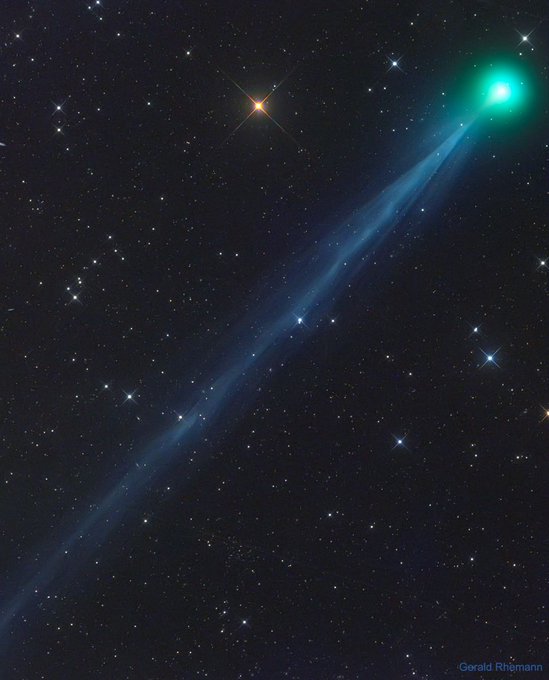
A new comet is approaching the sun, and by mid-May, it may glow brightly enough to be visible in the night sky.
Last month, Comet ATLAS took center stage as it was getting brighter and brighter, showing promise that it would eventually be bright enough for people to see without a telescope. But then, the comet broke apart unexpectedly, dashing any hopes of it being visible to the naked eye.
Now, a new comet has appeared, named Comet SWAN, and it has the potential to outshine some stars in the sky.
Comet SWAN is projected to get brighter by the middle of the month and will make its closest approach to Earth on May 13 at a distance of around 50 million miles.
“That's not a particularly close approach; nevertheless, it could put on a good show. If current trends continue, the comet may be brighter than 3rd magnitude (like stars in the Pleiades) as it glides through the constellation Pisces,“ SpaceWeather.com said.
Comets can be fickle and unpredictable, so only time will tell the fate of Comet SWAN. Be sure to follow AccuWeather Astronomy on Twitter for future updates on the comet.

Looking back at April

On the night of April 7 into April 8, people around the globe were treated to the biggest and brightest supermoon of the year. Just one week later, the moon put on another show, meeting up with Jupiter, Saturn and Mars in the early-morning sky on April 15.
By the time that the Lyrid meteor shower reached its peak near the end of the month, the moon was in its new phase. This allowed onlookers to enjoy the first meteor shower since January on a night without the moon shining bright.
A mile-wide asteroid zipped past the Earth on Wednesday, April 29, giving some people the opportunity to spot the giant space rock with their telescopes. Although it was called a "Potentially Hazardous Asteroid," it poses no risk of hitting the planet in the near future.
Deeper in the expanse of the universe, astronomers have discovered a star orbiting a supermassive black hole in the heart of the Milky Way galaxy in such a way that once again fell in line with Einstein’s theory of general relativity.
RELATED:
Back on Earth, NASA attached a small helicopter to the Perseverance rover that will travel to Mars later this year. This will become the first helicopter to fly on another planet.
Astronomers celebrated the anniversary of the Hubble Space Telescope, which launched into space 30 years ago. Hubble has sent back incredible images of the universe and has led to major discoveries.
NASA also reflected on the Apollo 13 mission, which took place 50 years ago in April of 1970. This mission is often referred to as a "successful failure" as NASA was able to bring three astronauts safely home after their spacecraft suffered a major malfunction on its journey to the moon.
Keep checking back on AccuWeather.com and stay tuned to the AccuWeather Network on DirecTV, Frontier and Verizon Fios.

Record-challenging heat to scorch the south-central US

Updated May. 3, 2020 11:00 AM


After a blisteringly hot day across much of the Southwest and south-central United States on Friday and Saturday, residents may be looking for relief from the summerlike pattern.
But AccuWeather forecasters say the heat is likely to persist into Monday.
"The same pattern that caused summerlike heat to build along the California coast and sent thousands to area beaches has shifted eastward, allowing temperatures to climb over a large part of the central U.S.," AccuWeather Lead Long-Range Meteorologist Paul Pastelok said.
RELATED:
The major atmospheric influence on this prolonged, unseasonably hot pattern for the southwestern and south-central U.S. is the position of the jet stream. A northward bulge in the jet stream over the southwestern U.S. during much of the latter half of April allowed warmth to build significantly over the area by confining any cooler, moist air to the Pacific Northwest.
On Friday, high temperature records were in jeopardy across the Four Corners region and the southern Plains.
Many locations from New Mexico to Texas, reached high temperatures that either broke or tied records, while cities like Phoenix and Denver fell just short.
On Friday, Albuquerque, New Mexico, as well as Amarillo and El Paso, Texas, all tied previous record high temperatures from 1992, reaching 88 F, 95 F and 96 F respectively.
Several locations in western Texas flirted with triple-digit temperatures on Friday. Midland, Texas, recorded a high of 101, breaking its previous record of 99 from 2009.
On Friday, Lubbock, Texas, topped out at 101, shattering its previous record of 96 in 2012. Lubbock also recorded its first 100-plus degree Fahrenheit day of the year, reaching a temperature more than 20 degrees above average for early May.
Record-challenging heat once again settled over the south-central U.S. on Saturday. Cities including El Paso and Lubbock, Texas, once again tied high temperature records.
"On Saturday, Midland, Texas, set a record high temperature of 104 F. This shatters the previous record of 98 from 2012. Midland is also on a 2-day streak of breaking both the record for high temperature and warmest low temperature on the same day," stated AccuWeather Meteorologist Mary Gilbert.
Meanwhile, highs were in the 90s for much of southern Arizona and New Mexico, through central Texas, with highs in the 80s across northern Arizona, through Oklahoma, and into southern Kansas.
Similar high temperatures are expected to persist over the area into Monday.
Unseasonable warmth will also seep eastward into the lower Mississippi Valley into Monday.
Many locations can experience temperatures 5-10 degrees above average for early May as highs in the upper 80s are forecast.
As areas across the southern tier of the U.S. deal with midsummerlike heat, many are yearning to get some fresh air during COVID-19 lockdowns.
"Anyone who does spend time in the sun should make sure to drink plenty of water, lather on the sunscreen and wear a hat to protect against sunburn and heat-related illnesses," AccuWeather Meteorologist Renee Duff said.
With unseasonably hot and dry conditions in the forecast, the threat for wildfires will also present itself over portions of the south-central U.S. Portions of Arizona, New Mexico, Colorado and Texas, will face an elevated risk for the duration of the weekend.
"An elevated risk of wildfire ignition will be present most days due to leftover dry brush from the winter and gusty winds. Higher temperatures can cause humidity levels to plummet and allow any sparks to rapidly grow into a large blaze," AccuWeather Senior Meteorologist Alex Sosnowski said.
Keep checking back on AccuWeather.com and stay tuned to the AccuWeather Network on DirecTV, Frontier and Verizon Fios.

These 2 major European cities received an entire spring's worth of rain in April

Updated May. 3, 2020 10:08 AM


A few locations in Europe were deluged with an entire season's worth of rainfall in April that will not only shape the end of spring but could also influence the forecast going into the summer.
Some Europe cities, like Dublin, Rome and Berlin, were missed by multiple storms during April, leading to a drier-than-normal month. However, the stormy pattern that set up over the Iberian Peninsula produced wetter-than-normal conditions.
"A total of 263 mm (10.35 inches) of rain fell in Barcelona, well over the normal amount for the month of April," said AccuWeather Meteorologist Tyler Roys.
Barcelona's average April rainfall is about 41.9 mm (1.65 inches).
This year's rainfall in April not only ended up being an astonishing 600 percent of normal, but it is also more rain than the city of Barcelona gets during the entire meteorological spring (March 1 - May 31).
Instances of flooding were reported all over northeastern Spain, several times throughout the month of April.
The rounds of wet weather also kept those social distancing during the COVID-19 pandemic from taking a walk outdoors.
But northeastern Spain was not the only Iberian Peninsula location to have an entire spring's worth of rainfall.
The rain that fell in Lisbon, Portugal, totaled a whopping 175.7 mm (6.9 inches) of rain, more than four times the normal rainfall amount in April. This amount also surpasses the average spring rainfall threshold of 158 mm (6.2 inches).
"What makes this an even more extreme case for the Iberian Peninsula is that this phenomenal rainfall followed an already wetter-than-normal March," added Roys.
From the start of March through the end of April, Lisbon's accumulated rainfall fell just short of the 200 mm (7.9 inches) at 199.6 mm.
Although Madrid was well short of reaching the all-season average of 128 mm (5 inches) during the month of April, the combined rainfall from March and April has already topped the average at 129 mm of rain so far this spring, with the whole month of May still to go.
RELATED:
Going forward, much of the Iberian Peninsula will get a break from wet weather with a surge of early-summer warmth at the start of May.
"After a rather uneventful early May, one or two storms are forecast to target the region in the middle of the month. These storms could bring some heavy rainfall as well as yield some cooler conditions," said Roys.
The month is forecast to end with more summerlike warmth and dry conditions.
Rain coming at this time of year is a double-edged sword for the area. More persistent wet weather will keep things green and wet longer, delaying the start of the fire season.
"It is almost inevitable that it will get hot and dry during the summer, given the climate of the region. When that occurs after a wetter spring, the excessive brush just becomes available as fuel to any wildfire that starts," Roys said.
Keep checking back on AccuWeather.com and stay tuned to the AccuWeather Network on DirecTV, Frontier and Verizon Fios.

Man missing at sea for nearly 2 weeks found alive in life raft off Washington coast

  One of two men missing at sea for nearly two weeks was found alive on Thursday by a Canadian fishing boat in a life raft in Canadian water...