Saturday, August 3, 2019

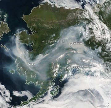
Smoke from Siberian forest fires traveled across Bering Sea to US, Canada

By Adriana Navarro, AccuWeather staff writer


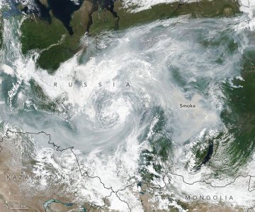
The smoke from over 400 forest fires in Siberia reached Alaska and portions of the west coast of Canada by July 31, according to NASA.
The Russian regions of Irkutsk, Buryatia, Sakha and Krasnoyarsk have declared states of emergency as the smoke chokes cities downwind, according to the Associated Press. All smoke can be hazardous, especially for the young or elderly.
However, NASA scientists don't believe the smoke will be traveling low enough in the U.S. to impact air quality.
Siberia smoke
Smoke from a multitude of wildfires in Siberia has swept across the Pacific and reached Alaska and northwestern Canada. (NOAA/NASA)

"The smoke travels at such high altitudes that it's unlikely to significantly impact air quality in the U.S., unless wind currents reach the surface," Atmospheric Scientist Colin Seftor said. Seftor works at NASA's Goddard Space Flight Center and has been tracking the smoke through its journey, according to the National Oceanic and Atmospheric Administration.
AccuWeather Senior Meteorologist Bob Smerbeck said that a storm tracking from Russia across the Bering Sea and into Alaska had steered the smoke into the area.
"Smoke can still be an issue this weekend," Smerbeck said.
NASA identified the smoke through an aerosol index from the Suomi-NPP satellite's Ozone Mapping and Profiler Suite (OMPS) instrument.
According to Russia's Federal Forestry Agency, more than 2.7 million hectares (6,671,845 acres) of Siberian forest is currently ablaze across six different Siberian and Far East regions. It all adds up to about the size of Massachusetts.
Russian officials have stated that although the fires have not encroached upon populated areas, about 800 cities are blanketed in heavy smoke, including larger cities such as Noosibirk, Krasnoyarsk and Chita, the AP reported. It is suspected that some of these fires were started by lightning strikes.
Over 300 of the forest fires are burning in remote areas of Siberia that are "difficult to reach," the Avialesoohrana forest protection agency said, according to DW News.
The agency is not fighting the fires in the remote areas that are burning up to 2.88 million hectares (7.12 million acres) because "there was no threat to population centers and economic objects, and the projected losses through firefighting surpass the potential damage of the fires," according to a statement from the agency cited by the Interfax news agency.
"There will be a storm system crossing Siberia that will cause showers and thunderstorms over the fire areas this weekend, which will help to put out the fires, but lightning could also start new ones," Smerbeck said.
"The pattern may shift later next week as storms with rain and cooler air shift eastward into the western regions of the fire zones. It may take a while to reach the central and eastern fire zone areas," he added.

Friday, August 2, 2019

Heavy rain to flood eastern India next week while monsoon continues in southwest

By Courtney Spamer, AccuWeather meteorologist


Heavier, tropical rain is expected to move across eastern India next week after a dry spell.
Monsoon downpours have spread over much of India in recent weeks bringing the country vital rainfall for water supplies and agriculture. However, not every region has received the needed rainfall.
India's southeast state of Tamil Nadu has been largely missed by any significant rainfall since the start of the yearly southwest monsoon. Some downpours dampened northeastern parts of the state, including Chennai, in late July. However, this has not been able to put more than a dent in the water shortages currently affecting the city of approximately 10 million people.
It's also been drier than normal in northeastern parts of India, including parts of West Bengal, Jharkhand and Odisha. The city of Kolkata had only 110 mm (4.35 inches) of rainfall in July, well shy of the average of 300 mm (11.85 inches) for the month.
India 8/1

The southwest monsoon has kept places along the western shores, including Mumbai, quite wet so far this summer, helping to replenish water supplies. While this monsoonal moisture is expected to continue in western parts of the country, a new low will bring tropical moisture to eastern parts of India.
After passing over the Indochinese peninsula, this low, which was once Tropical Storm Wipha in the Western Pacific Ocean, will emerge into the waters of the Bay of Bengal early in the week.
The weather pattern is not conducive for Wipha to redevelop in the Bay of Bengal; however, it will bring a wave of heavy rainfall into what has recently been a dry spot in eastern India.
IndiaNextWk

From late in the weekend through the middle of next week, this tropical low will creep farther and farther inland, spreading with waves of heavy rain.
This rain will bring heavy downpours that can not only reduce visibility but also lead to flash flooding. With how dry the soil has been so far in July, the ground will have difficulty absorbing a lot of rain in a short period of time. Standing water will last well after rainfall has ended, possibly cutting off some villages and cities.
The heaviest rain will stretch from the coast of Odisha and West Bengal to Uttar Pradesh Monday through Wednesday. Total rainfall amounts of 75-150 mm (3-6 inches), with an AccuWeather Local StormMax™ of 225 mm (9 inches), are possible by the middle of the week across some locations.
Late in the week, the low will continue to move across India and toward the Arabian Sea. This will spread even more heavy rainfall to western India.
Meanwhile, the heavy southwest monsoon will continue for the next week, bringing heavy rainfall from coastal Karnataka and Maharashtra, including Mumbai. The city had over 140 cm (56 inches) of rainfall in the month of July.

Charges put on hold against NYC father who left twins in hot car

By Mark Puleo, AccuWeather staff writer


The criminal case against Juan Rodriguez, the father of the 1-year old twins who died in a hot car last week, has been put on hold.
Denisse Moreno, a spokesperson for the Bronx County District Attorney's Office, told reporters that there is no grand jury action at this time and that the next court date will be Aug. 27. Dozens of family and friends joined the Rodriguez family at the packed courthouse to provide support during their trying time.
According to NBC New York, Bronx County District Attorney Darcel Clark decided to hold off on bringing the case before a grand jury due to the need for further investigation. The news station reported that while the criminal case against Rodriguez is active, prosecution is paused.
“Mr. Rodriguez consented to a full search of his phone, his car,” Joey Jackson, Rodriguez’s lawyer, said on Thursday. “He has nothing at all to harbor and hide other than to feel misery and sorrow.”
2019 hot car fatality stats

The 39-year-old Rodriguez was arrested on Friday on felony charges of second-degree manslaughter and criminally negligent homicide, along with misdemeanor counts of endangering the welfare of a child. According to kidsandcars.org, about 50 percent of people involved with cases like these face charges, with about a 30 percent conviction rate in those cases.
“A child is unknowingly left in a car by a parent, that is not criminal behavior,” Amber Rollins, director of kidsandcars.org, told AccuWeather. “The whole point of criminalizing something is deter it from happening in the future. If somebody is unaware that they’re doing something, criminal charges aren’t going to change that.” 
Hot car fatality totals

Rodriguez told police that he thought he had dropped the twins off at daycare and had blanked in making his tragic mistake.
In the courtroom, Rodriguez sobbed and prayed throughout the proceedings. His wife, holding their 3-year old, sat in the first row to support him just as she had last week in a statement she released after the incident.
Jackson added that Rodriguez and his family will work with legislators in the future to protect other families from facing the horrors that they have endured.
“We want to see a system that can detect the presence of a child in a vehicle,” Rollins said, regarding technological advances for situations like these. “As standard equipment in all vehicles, not just a few models.”

'Stop! Stop! She’s under!' Police perform treacherous water rescue along dam

By Amanda Schmidt, AccuWeather staff writer


It was a warm, pleasant day in Des Moines, Iowa, on Monday, prompting some residents to take advantage of the city’s numerous lakes and rivers. What likely started as a fun idea quickly escalated into a potentially life-threatening experience for two residents.
Along the Des Moines River, two people found themselves in a precarious situation when their inflatable raft capsized near a dam. The Des Moines Police Department (DMPD) said in a Facebook postthat they were notified of people yelling for help near the Scott Street Dam in Des Moines around 9:30 p.m., local time, on Monday, July 29.
Six Des Moines police officers quickly responded to the cries for help and found two people, a 44-year-old man and a 50-year-old woman, “trapped in the turbulent waters of the dam.” The rushing water was so strong that the victims were “pulled below the surface of the water” at times.
River rescue Des Moines 8-1-2019
Two people were rescued by the Des Moines Police Department after their inflatable raft capsized near a dam along the Des Moines River in Iowa on Monday, July 29. (Video screenshot/ Des Moines Police Department via Storyful)

Body cam footage released by the police department captures the dramatic rescue, where two people are seen wearing orange life vests and clinging on to a rope extended by the rescuers. There are a few heart-stopping moments where the survivors are seen struggling in the fast-moving water and even disappear under the currents at times.
“Just keep holding on; don’t let go,” the officer yells to the woman seen struggling in the water below. “Get your head up!” he shouts, as he tried to pull the victims to safety. Later in the video, the woman appears to disappear from view, and the officer says “Stop! Stop! She’s under!”
After the rescue, the victims were transported to a local hospital where they were treated and released. Meanwhile, the officers involved dried off and went back to work.
The police officers involved have not been publicly identified. The survivors were identified as a homeless couple by police, and DMPD Sgt. Paul Parizek told AccuWeather that they have since had a difficult time tracking them down.
“DMPD is proud of the courageous and selfless commitment of these officers, and of every member of our family who serves this community, 24/7!” the police said.
The city is divided by two rivers. This spring and into much of the summer, Des Moines has experienced high rivers and flooding due to excess rainfall. Fortunately, the river levels were low at the time of the rescue.
“We don't have the flooding that we had two or three weeks ago, which would've made this 10 times worse,” Parizek told AccuWeather. “If we had the flooding that we had a couple of weeks ago, we wouldn't have been able to attempt to the rescue the way that we did.”
As the river water runs across the low-head dam at this location, it creates a spinning backwash called a "boil." According to Parizek, it’s not uncommon for people to get stuck in these boils and drown.
At the time, the water was low enough that the officers were able to walk out on top of the low-head dam and stand on it as they conducted the rescue. In the video, the river can be seen flowing swiftly over the dam through their feet, further intensifying the rescue.
Des Moines Dam
A fisherman casts his line below the Scott Street dam in Des Moines, Iowa, on April 1, 2015. These walls of concrete, called low-head dams, outlasted their original purpose long ago. The seemingly gentle dams hid a a secret: they have dragged hundreds of unsuspecting people into their churning waters and drowned them. (AP Photo/Charlie Neibergall)

The officers created a small human chain where one officer was at the lead, another officer was holding him and another person was feeding the rope.
“You can see what a physical feat it was for these officers to fight against that turbulent water to pull these folks out,” Parizek said. Despite the struggle, the police were able to pull the folks to safety. “Everything that happened here, everything fell into place perfectly,” Parizek added.
The police officers in this video had just started their night shift and were two blocks away at the gas station preparing their vehicle for the night when they received the call. They were able to deploy much faster than the wet team was able to get boats in the river.
The majority of cops involved in the rescue were relatively new to the force, but they were able to calmly and effectively carryout the procedure, according to Parizek.
At the time of the rescue, the weather conditions were fairly calm. Temperatures were in the upper 70s and it was partly cloudy with a light breeze, according to AccuWeather Meteorologist Bill Deger.
While the weather was calm, Parizek said that they do not recommend going on the river in the dark, particularly after the flooding that the city has recently experienced.
“Our lakes and rivers are inviting places to relax, cool off, and play during the summer. Please, be safe and aware of your surroundings,” the police said in the Facebook post, urging residents to wear a lifejacket, to follow the posted warnings near dams, and turn around or exit.
“Too often, going over the dam will trap a person in the spinning waters, and the results are fatal. Fortunately, this story has a happy ending,” the Facebook post reads.

Southeastern US at risk for flash flooding, travel disruptions as deadly downpours persist

By Alex Sosnowski, AccuWeather senior meteorologist


Downpours will become more widespread over the southeastern United States into this weekend as tropical and non-tropical features converge and wring copious amounts of moisture out of the atmosphere.
While incidents of flash flooding will tend to be isolated and favor heavily-paved urban areas, there is a high likelihood of downpours spoiling outdoor plans from Florida, westward to Louisiana and northward to portions of Pennsylvania, New Jersey and southern New York state.
Friday Evening 3

At times, the downpours will extend to the Appalachians and spill farther west over portions of the Tennessee and lower Mississippi valleys.
Thursday's rain took a deadly turn turned when the heavy downpour caused a rock slide, which brought a downed tree on top of 73-year-old Barry Wallace's minivan on US 441 near Gatlinburg, Tennessee, according to WBIR 10 News.
According to authorities, Wallace was the only person in the car and died from his injuries.
Dana Soehn, a spokesperson for the park, told the news agency that the area had received over 4 inches of heavy rain in just a little over an hour.
A few states south, St. Petersburg, Florida, received 3.62 inches of rain on Thursday, which set a daily rainfall record.
Other portions of the Sunshine State were also doused with more than an inch of rain falling on Orlando, Vero Beach and Jacksonville to name a few.
Farther north, rain poured down as well over the mainland part of the Southeast states.
Greenville, South Carolina, received 3.47 inches of rain on Thursday, which also set a daily rainfall record.
Downpours also drenched part of the Atlantic metro area, as well as Macon, Georgia; Charlotte, North Carolina; Lynchburg, Virginia; and Patuxent River, Maryland. Each of these locations received more than an inch of rain on Thursday.
These and other areas can expect more rain to fall through Sunday.
Saturday

There is the potential for 1-3 inches of rain to fall per day in some locations. In some cases, the rainfall can occur in as many hours.
Motorists should expect delays as downpours bring sudden low visibility and cause water to collect in poor drainage areas on streets and highways.
However, while these will be less-than-ideal conditions at the beach, ballpark or fishing hole, it will not rain the entire time through this weekend even at the rainiest spots.
Sunday

With some exceptions, the bulk of the downpours will occur between 3 and 9 p.m. local time.
Boaters and anyone outdoors should keep an eye out for rapidly changing weather conditions. Bathers should use caution, in addition to the risk of lightning strikes, rip currents may be stronger and more frequent than average.
The wet pattern is being brought about by three main factors. These include a stalled front, a southward dip in the jet stream and sprawling tropical moisture over the Southeast states with a weak tropical disturbance just offshore over the Atlantic.
During the weekend, as the tropical disturbance at the root of the moisture moves more to the northeast, it is possible that downpours become less numerous over the Florida Peninsula.
However, the overall unsettled pattern is likely to persist over the Southeast through the first part of next week.
By the time the pattern breaks down later next week, some areas in the Southeast may have received 6-10 inches of rain, even though the heaviest rain will fall just offshore of the Atlantic coast.
Download the free AccuWeather app to keep track of the latest tropical activity. Keep checking back for updates on AccuWeather.com and stay tuned to the AccuWeather Network on DirecTV, Frontier and Verizon Fios.
Podcast banner for news stories

Man missing at sea for nearly 2 weeks found alive in life raft off Washington coast

  One of two men missing at sea for nearly two weeks was found alive on Thursday by a Canadian fishing boat in a life raft in Canadian water...