Jonathan Belles
A disturbance that is making an unusually late voyage across the deep tropical Atlantic could form into a tropical depression or storm later this week.
Here's where this system is located right now: The disturbance, a tropical wave tagged Invest 94L by the National Hurricane Center, is located at a rather low latitude between the Cabo Verde Islands and the Lesser Antilles. This system has been slow to organize so far, but environmental conditions could improve for it to develop into a tropical depression or storm over the next few days.
The next named storm of the season will be “Tammy.”
 Atlantic Overview
Here's where Invest 94L is headed in the coming days: The system is moving westward across the main development region (MDR) of the Atlantic because of a hefty Bermuda high locked into place to its north. Clockwise flow around the Bermuda High will push it near or north of the eastern Caribbean islands by this weekend.
Interests in the eastern Caribbean islands should monitor the progress of this tropical system throughout the week.
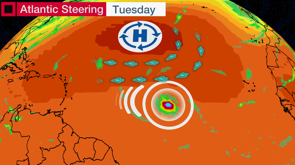
System could form in an odd location for mid-October: The tropical Atlantic, or MDR, is the strip of ocean that stretches from Africa to the Caribbean south of 23.5 degrees north latitude. Named storms more commonly form in this region in the peak months of August and September.
That’s when water temperatures are most favorable for development in that region. They begin cooling off by late September and become too cool for tropical development by the end of the calendar year.
But this year, water temperatures are running a couple of degrees above average and still well above the roughly 80-degree threshold needed for tropical development. Tropical systems don’t care what the calendar says.
Caribbean impacts remain unknown: With several days to go, there are still many things to figure out in this forecast. The strength of the system and its precise track are two of those things that will dictate what, if any, impacts may occur in the islands.
Interests in the eastern and northern Caribbean should keep checking the forecast over the week.
 Model Tracks
The Weather Company’s primary journalistic mission is to report on breaking weather news, the environment and the importance of science to our lives. This story does not necessarily represent the position of our parent company, IBM.
The Weather Company’s primary journalistic mission is to report on breaking weather news, the environment and the importance of science to our lives. This story does not necessarily represent the position of our parent company, IBM.


No comments:
Post a Comment