Jonathan Erdman
A tropical storm might form in the western Caribbean Sea late this week and could become a threat to parts of Central America by this weekend as the 2023 Atlantic hurricane season enters its final month.
What's out there right now: An area of low pressure with some showers is in the eastern Caribbean Sea, bringing soaking rain to the Virgin Islands and parts of Puerto Rico.
Another area of low pressure near the Bahamas is no longer expected to develop, while Tropical Storm Pilar is swirling in the Pacific Ocean off the coast of Central America.
 NHC Development Chance And Active Storm(s)
What's the Caribbean disturbance's future: There are two factors that have us concerned about development.
First, it will move over some of the warmest water anywhere in the Atlantic Basin, still much warmer than usual for this time of year. Second, wind shear – the change in wind direction and/or speed with height – is forecast to be relatively low in the western Caribbean Sea later this week, something rather unusual in a stronger El Niño autumn.
Therefore, this system has a good chance of becoming Tropical Storm Vince.
(MORE: What Happens If Hurricane Season Runs Out Of Names?)
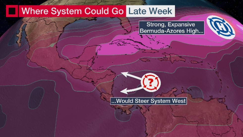
As far as where it may track, the majority of computer forecast models suggest high pressure may build westward enough to keep this system on a general westward path toward some part of Central America this weekend.
Interests throughout Central America and the western Caribbean should monitor the progress of this system closely for potential forecast changes.
Further beef up your forecast with our detailed, hour-by-hour breakdown for the next 8 days – only available on our Premium Pro experience.

Pilar could be a soaker, too. Earlier, we mentioned Tropical Storm Pilar is spinning in the Eastern Pacific Ocean.
Pilar will take a weird track, first drifting closer to the coast of El Salvador through early Wednesday, then backing up and moving back out to sea the rest of the week.
This closer approach could bring locally heavy rainfall to parts of Central America from Guatemala to Nicaragua and possibly Costa Rica the next several days. And this could saturate the ground before the Caribbean system arrives, increasing the flood and mudslide danger into early next week.
(INTERACTIVE MAP: Pilar Forecast Path, Radar)
November isn't a throwaway month. You may have thoughts of cold and snow when the calendar turns to November. But while not nearly as active as September, it's still the final month of hurricane season.
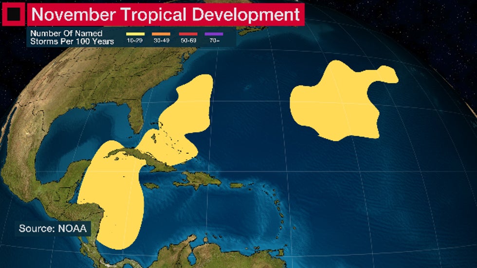
According to National Hurricane Center statistics, November has averaged one named storm and one hurricane in recent decades. When they do form, the western Caribbean Sea is a typical November development hot spot.
 Typical development areas in November in the Atlantic Basin
Recent Novembers have been active. Last year, Hurricane Nicole slammed into Florida, chewing away parts of the state's Atlantic coastline. In 2020, hurricanes Eta and Iota made Category 4 landfalls along northern Nicaragua's Caribbean coast within 15 miles of each other just 13 days apart.
Jonathan Erdman is a senior meteorologist at weather.com and has been covering national and international weather since 1996. His lifelong love of meteorology began with a close encounter from a tornado as a child in Wisconsin. He studied physics at the University of Wisconsin-Madison, then completed his Master's degree working with dual-polarization radar and lightning data at Colorado State University. Extreme and bizarre weather are his favorite topics. Reach out to him on X/Twitter, Facebook and Threads.
The Weather Company’s primary journalistic mission is to report on breaking weather news, the environment and the importance of science to our lives. This story does not necessarily represent the position of our parent company, IBM.
The Weather Company’s primary journalistic mission is to report on breaking weather news, the environment and the importance of science to our lives. This story does not necessarily represent the position of our parent company, IBM.

No comments:
Post a Comment