A Texas state trooper was seriously injured in one of many accidents on Tuesday across the southern Plains as a mixed bag of precipitation from freezing rain to thundersleet spread through the region.
After mainly impacting Texas during the morning and early afternoon hours Tuesday, the ice storm has moved slightly to the northeast as the day went along, seen hitting Arkansas and Tennessee in multiple videos. In Mountain Home, Arkansas, on the northern tip of the state near the Missouri border, one resident was able to pick up a sizable piece of ice from the front yard before smashing it on the ground:
In Lakeland, Tennessee, just east of Memphis, sleet was seen falling across a neighborhood in the late afternoon hours:
The sleet continued into the evening in Tennessee, as evidenced by this video from Lobelville, 75 miles southwest of Nashville:
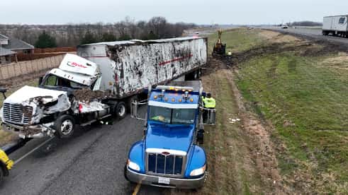
A vehicle slid under a truck due to the slick roads in Irvine, Texas, on Monday, Jan. 30, 2023. There were no reports of serious injuries in the crash. (Bill Wadell/AccuWeather)
School closings due to this week’s ice storm have extended into one of the South’s largest hubs. On Tuesday, Memphis-Shelby County Schools announced that schools will be closed Wednesday, pointing to “hazardous” weather conditions. Before and after-school activities are also postponed. District administration buildings will also close, and school-based personnel should not report to work. Accidents have been reported in the Memphis area Tuesday, including an early-morning crash off Interstate 55 that closed northbound lanes.
As reports continue to come from the Dallas-Fort Worth area regarding travel impacts, the amount of precipitation Tuesday has officially become record-breaking. The metro area set a new daily snowfall record Tuesday, with 1.3 inches of snow landing in the area. While much of the precipitation was sleet, for the purposes of National Weather Service record-keeping, sleet on the ground “is considered the same as snowfall.” The 1.3 inches of accumulation broke a daily record nearly 40 years old, last set in 1985 with 1.2 inches of snowfall.
Tuesday’s rounds of rain and ice hindered travel not only on the roads, but also in the air. Hundreds of flights were either canceled or delayed on Tuesday, the majority of which were at Dallas-Fort Worth International, according to FlightAware. At Clinton International Airport in Little Rock, Arkansas, travelers were anxious the wintry weather would impact their flights as well. One person who had arrived to pick up her husband told AccuWeather National Reporter Emmy Victor that she thinks his flight came in just in time. “I was worried that his flight would get delayed or canceled coming back here, but luckily because he just landed I think we just beat, we just made it I think with picking him up right now,” Arkansas resident Robin Green told Victor. While only 11 flights arriving at the airport were canceled, that number made up 21% of total arrivals, according to FlightAware.
AccuWeather’s Emmy Victor reported live from Arkansas on Jan. 31 as people throughout the South dealt with delayed and cancelled flights due to icy weather.
Extreme Meteorologist Reed Timmer was in the Dallas-Fort Worth metro area Tuesday, showcasing the dangers along the roads amid an ice storm. Outside of Waxahachie along Interstate 35 East, roughly 30 miles south of downtown Dallas, Timmer pointed out that “pure freezing rain” was already a quarter-inch thick, sticking to trees and accumulating on the roads. “Very dangerous conditions out here … [conditions] started off as sleet, and now we’re shifting over [to freezing rain]” Timmer said. Timmer was also live near Rockwall, Texas, just east of Dallas, covering a traffic standstill over Lake Ray Hubbard.
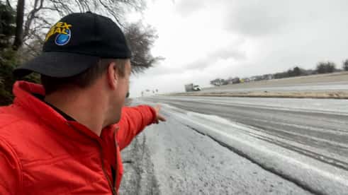
Extreme meteorologist Reed Timmer is in Dallas, Texas, showcasing the road hazards freezing rain has created.
Texas Department of Public Safety (DPS) officials have released new updates to the incident that resulted in serious injuries to a trooper in Navarro County. According to DPS Sgt. William Lockridge, speaking with AccuWeather’s Amy Haller, DPS Trooper Curtis Putz positioned his car “in such a manner to protect others” while investigating an accident on Interstate 45 south at Exit 220 near Corsicana, about 50 miles south of Dallas. While investigating, a car sliding on ice hit his vehicle, pinning Putz between his vehicle and a guardrail. It is unknown at this time if the car that struck Putz’s vehicle was speeding, though DPS Director Steven C. McCraw said earlier Tuesday that the driver was traveling “too fast for conditions.” Lockridge noted that “it will be a long road to recovery,” and asks to “keep Trooper Putz and his family in your thoughts and prayers.”
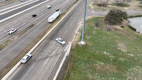
Conditions in the eastern Dallas suburbs have continued to deteriorate Tuesday afternoon. On Interstate 20 near Terrell, Texas, 30 miles outside downtown Dallas, several semi-trucks were seen crashed off the road. AccuWeather National Reporter Bill Wadell stated that ramps and bridges in the area are “very slick,” and that ice accumulation on trees has been building.
About 15 miles east of Terrell in Wills Point, Texas, the ice accumulation on tree branches has caused them to bend and snap under the weight.

As travel conditions deteriorate across Texas and Arkansas, AccuWeather Chief Meteorologist Jonathan Porter said areas that were hard-hit Tuesday morning, including portions of I-40 and I-55, will be affected by more ice for the evening commute. “It’s a big mess and it’s really an annoying weather pattern here because this isn’t like a storm system that arrives in your area and then departs and you can sort of get back to normal pretty quickly,” Porter said. “But it’s round after round after round of ice that’s prolonging the dangerous travel and creating all kinds of disruptions.” By Tuesday afternoon, a large traffic jam had grown along I-40 near West Memphis, located in eastern Arkansas. Several accidents had occurred earlier due to the ice accumulation in the area.
Icy conditions weren't just limited to the southern Plains Tuesday. In the area of Evansville, Indiana, sleet began accumulating Monday evening, with more than two-tenths of an inch of frozen precipitation recorded at Evansville Regional Airport. During the morning commute on Tuesday, dozens of accidents were reported in Gibson County, Indiana, which borders both Illinois and Kentucky. With temperatures in the area being in the upper teens early Tuesday, road crews were challenged in clearing major roadways, as melting materials were less effective in the frigid conditions. Parts of western Kentucky could be in the path of more sleet and freezing rain before the ice storm concludes.
Power outages were building across the South Central states in the path of the wintry weather, including Texas and Tennessee. Over 20,000 customers in Texas, primarily in the northeastern portion of the state, were without power by Tuesday afternoon, according to PowerOutage.US. While the total number of power outages wasn’t as high in other states, freezing rain and sleet had moved through Memphis and Shelby County on Monday afternoon, knocking out power to more than 5,000 Memphis Light, Gas and Water customers, according to the company. Over 2,000 of the provider’s customers were without power as of Tuesday afternoon, according to PowerOutage.US. Both large portions of Texas and Tennessee’s Shelby County were under an ice storm warning on Tuesday.
The ice storm causing travel impacts in Texas has triggered a warning that hasn’t been issued in nearly five years. On Tuesday, the National Weather Service’s Fort Worth office issued an ice storm warning for the city, the first such warning in 1,803 days. The warning does not include Dallas. The last Ice Storm Warning was issued on Feb. 23, 2018. The warning, which lasts from 6 a.m. Wednesday through 6 a.m. Thursday also impacts western Fort Worth suburbs such as Stephenville, Denton and Decatur. Surrounding areas, such as Dallas and Waco, continue to be under a Winter Storm Warning.
Severe conditions due to the ice storm in Texas have caused havoc at several of the state’s major airports. In the Dallas-Fort Worth area, both Dallas-Fort Worth International Airport and Dallas Love Field have canceled hundreds of Tuesday flights, according to airline tracking site FlightAware. A total of 423 departing flights at Dallas-Fort Worth have been canceled as of Tuesday afternoon, with another 465 flights scheduled to arrive at the airport also canceled. At Dallas Love Field, 137 departing flights were canceled, along with 125 arrivals. Roughly 215 miles south at Austin-Bergstrom International Airport, 129 departing flights and 148 arrivals were canceled Tuesday. Overall, over 3,000 flights within, into or out of the United States have been delayed as of Tuesday afternoon, with another 1,700 canceled.
As Tuesday’s ice storm begins to move through Arkansas, Gov. Sarah Huckabee Sanders issued a state of emergency, with power service restoration a top priority for the state. As of Tuesday afternoon, Arkansas has just 1,275 tracked power outages, according to PowerOutage.US, but Sanders stated that ice could cause power lines to break. The declaration was also made to facilitate a quick resupply of goods interrupted by worsening road conditions. In advance of the storm, Sanders activated the Arkansas National Guard winter weather support teams. Icy conditions have already caused one fatality in Arkansas, a fatal crash reported early Monday morning in Benton County.
A large swath of Interstate 40 in Arkansas was congested with trucks and vehicles as an icy mix created dangerous travel across the southern Plains Tuesday. At least two accidents led to a major standstill on I-40 in Arkansas on Tuesday morning, according to the Arkansas Department of Transportation (ARDOT). “Please avoid I-40 westbound between Forrest City and Memphis if possible. The route is covered in ice/ice patches and we are dealing with two accidents,” ARDOT said in a Twitter update. Shortly after 10 a.m. CST, the accidents were both cleared on traffic flow resumed to normal on the interstate.

(Arkansas DOT)
AccuWeather Chief Meteorologist Jonathan Porter said the ice has been creating travel headaches for many across Arkansas and Texas on Tuesday. “We’re seeing that all across portions of eastern Arkansas and similar travel problems across much of the Dallas-Fort Worth metroplex, further southwestward, into central Texas,” Porter said.
As more icy precipitation is expected to fall throughout Tuesday across the southern Plains, A.J. Gary, the director of Arkansas’s Division of Emergency Management urged people to stay off the roads. “The weather that we had [Monday night] and the weather that is coming through [Tuesday] afternoon, we’re just urging people, if they don’t have to get out and drive, please don’t,” Gary said to AccuWeather in an interview.
A Texas State Police trooper was seriously injured Tuesday morning when he was struck while responding to one of the numerous crashes reported in the Dallas-Fort Worth area due to an ice storm impacting the region, authorities said.
Steven C. McCraw, director of the Texas Department of Public Safety, said a driver who was traveling “too fast for conditions” lost control of their vehicle and hit the trooper on Interstate 45 south at Exit 220 near Corsicana in Navarro County, about 50 miles south of Dallas. McCraw said it took the ambulance about an hour and a half to get to the hospital due to the deteriorating road conditions. McCraw confirmed the injury during a press conference with Gov. Greg Abbott and state emergency officials Tuesday.
State Rep. Cody Harris offered prayers in a post on Twitter: "Taylor and I are praying for the State Trooper who was involved in a terrible accident in Navarro County this morning. Join us as we pray for the doctors tending to him and for his family. STAY OFF THE ROADS until the weather has cleared.”
Information on the condition or identity of the trooper has not been released.
Storm chaser Brandon Clement captured video of no fewer than 12 vehicles losing control on the same icy bridge in the Dallas area on Jan. 30.
In a press conference on Tuesday afternoon, Texas Gov. Greg Abbott said there 4,000 professionals across 14 agencies were responding to the winter storm unfolding across the state. Abbott added that the ice is creating dangerous conditions on the roads. “The roadways are very hazardous right now. We cannot overemphasize that,” Abbott said at the press conference. As power outages continue to mount across the state, Abbott confirmed that the outages were due to factors such as ice on the power lines and downed trees. “The power grid itself is functioning effectively as we speak,” said Abbott. “There’s not anticipated to be any challenges to the power grid in the state of Texas.” Texans can call 211 to locate warming centers, if necessary.
The severe winter weather affecting the southern Plains has resulted in a disruption to FedEx’s operations. “The weather has created potentially hazardous operating conditions, and the safety of our team members remains our number one priority,” FedEx wrote in a press release on Tuesday morning. The company experienced “substantial disruptions” at its Memphis, Dallas/Fort Worth and Indianapolis hubs Monday evening due to “severe winter weather.” According to the press release, “potential delays” are possible for any package across the U.S. with a delivery date of Tuesday, Jan. 31, 2023.
A vehicle slid under a truck due to the slick roads in Irvine, Texas, on Monday, Jan. 30, 2023. There were no reports of serious injuries in the crash. (Bill Wadell/AccuWeather)

The winter storm turning parts of the south-central U.S. into a sheet of ice isn’t anywhere close to finished. AccuWeather forecasters say the storm could produce a high risk to lives and property before it winds down later this week.
AccuWeather forecasters say it is possible that some locations may pick up a glaze between 0.50 and 0.75 of an inch, which can bring widespread tree damage and power outages. This much ice could build up in the zone from near Dallas, southward to just north of San Antonio to just east of San Angelo, Texas. Another pocket where this much ice is possible will be from portions of central Arkansas to western Tennessee.

“Any type of paved surface can quickly become hazardous to travel on,” AccuWeather Chief Meteorologist Jonathan Porter said. “Even if surfaces only look wet, it is best to err on the side of caution and travel with extreme caution, or defer traveling until the icing event has come to an end.”
A round of freezing rain is forecast to impact the I-40 corridor from Memphis, Tennessee, area and into northern Mississippi, by Tuesday afternoon. Conditions were already deteriorating across the South Central states Tuesday morning, as the ice caused roads, bridges and overpasses to become treacherous. A few crashes had already been spotted down Sam Cooper Blvd. in Memphis, on Tuesday, including three separate accidents where at least one vehicle appeared to have veered into the median.
The flash of lightning followed by a rumble of thunder is synonymous with storms in the spring and summer, but when the conditions are perfect, the phenomenon can occur during winter storms. Generating lightning during a winter storm generally follows the same meteorological process as it would during a thunderstorm. As ice crystals clash together in turbulent updrafts charged particles are generated. When the charge builds up, the energy is released in a bolt of lightning accompanied by a clap of thunder.
“Thunderstorms during the warm season have a much easier time developing strong updrafts because there is more warmth and moisture to feed on and more instability aloft,” AccuWeather meteorologist Jordan Root explained. The updraft in winter storms is not typically as strong as thunderstorms, which is why it’s far less common to hear thunder during a winter storm. But the updraft in the storm that's producing sleet and freezing rain in Texas is strong enough to create thunder and lightning. Since the storm was producing sleet at the time of the thunder and flash of lightning, it is called “thundersleet.” When this phenomenon occurs further north, it is typically referred to as “thundersnow,” since the precipitation falling is snow.
AccuWeather National Reporter Bill Wadell captured the moment lightning illuminated the sky in Irving, Texas, located right outside of Dallas, Tuesday morning. AccuWeather’s lighting map shows multiple strikes of lighting in the Dallas area on Tuesday morning. Thundersleet was also reported just south of Oklahoma City on Tuesday morning.

Lightning caught on video as wintry weather affected the Irving, Texas, area on Jan. 31, 2023.
Over 160 lightning events have been detected across Texas and Oklahoma since 6 a.m. CST Tuesday in connection with the ongoing storm, including dozens of lightning flashes around the Dallas-Fort Worth metroplex. One Twitter user who was standing outside in the wintry weather in northeast Dallas managed to capture video of a cloud-to-ground lightning strike while it was sleeting. The bolt was followed up by a crack of thunder that drowned out the sound of sleet pellets bouncing off objects.
A switchover from sleet back to freezing rain has created dangerous conditions on the roads in Dallas, Texas. In a video AccuWeather National Reporter Bill Wadell shared on Twitter, cars could be seen parked on bridges and windshields were covered in a thin layer of ice. It only takes a thin layer of ice to create slippery conditions on the roadways. On Monday, numerous accidents were reported after ice created slick roads. In a video shared by Wadell, the hood of a car was seen wedged under a large tractor-trailer just outside of Dallas. The Texas Department of Transportation (TxDOT) is working around the clock to keep the roads drivable. “TxDOT crews are working hard to keep roads passable,” TxDOT wrote on Twitter. “Avoid travel; if you must, remember to move over or slow down for emergency, law enforcement, TxDOT, tow trucks and other vehicles.”
In Austin, Texas, conditions aren’t much better. According to a tweet from the Austin-Travis County EMS department, crews were responding to at least three rollovers, eight traffic injuries and two vehicle rescues. “Stay home! Stay safe! Stay off the roads!” Austin-Travis County EMS wrote on Twitter.

Multiple shades of blue and purple dotted AccuWeather radar early Tuesday around the Dallas/Fort Worth metroplex. Freezing rain, sleet, snow and ice were all evident on the radar that covered parts of northern Texas, with mostly sleet being reported around Dallas proper. Forecasters continue to advise those in the area to avoid traveling on Tuesday as road conditions will continue to worsen. Temperatures in Dallas were hovering around 27 F shortly before 9:30 a.m. local time.
Over 15 million people across the south-central states were under a winter storm warning on Tuesday with another 3 million primarily in Texas and Oklahoma under an ice storm warning. The winter weather alerts associated with the cold front moving through Texas included ice storm warnings, winter storm warnings and winter weather advisories, stretching as far eastward as West Virginia and Ohio.
Many of the advisories, which were impacting a population of over 20 million, are set to expire by Tuesday afternoon unless otherwise stated, but the other two warning types are likely to stick around a bit longer, lasting into Wednesday and Thursday. Winter storm warnings are typically issued when confidence is high that a winter storm will produce heavy snow, sleet or freezing rain and create dangerous conditions such as ice accumulation to trees or power lines, a life-threatening combination of snow and/or ice accumulation with wind, according to the National Weather Service. Ice storm warnings indicate that ice accumulation of at least a quarter of an inch is expected.

Winter storm warnings (dark blue), ice storm warnings (bright pink) and winter weather advisories (grey) stretched from Texas to West Virginia and Ohio on Tuesday morning.
An icy mix fell across the southern Plains on Monday, creating hazardous travel for many. In Willard, Missouri, which is just northwest of Springfield, 0.33 of an inch of freezing rain was reported. This was one of the highest amounts of freezing rain across the southern Plains on Monday. In Greenwood, Arkansas, which is just west of the Oklahoma-Arkansas border, 0.30 of an inch of freezing rain was reported. In Texas, multiple locations recorded 0.25 of an inch of freezing rain on Monday. AccuWeather forecasters say the ongoing storm will continue to bring an icy mix to the region through Tuesday.

Temperatures across the southern Plains were below freezing on Tuesday morning, making for a chilly start to the day. In Oklahoma, temperatures ranged from the single digits to the low 30s. In Arkansas, temperatures in the northern half of the state were in the teens to mid-20s, while the southern half of the state reported temperatures in the low 30s. Although temperatures are above freezing in southern Texas, the majority of the state is reporting temperatures below freezing on Tuesday morning.
On top of the chilly temperatures Tuesday morning, winds were gusting up to 25 mph in some locations, making it feel even colder outside. Due to the gusty winds in southern Oklahoma, AccuWeather RealFeel® Temperatures were below zero on Tuesday morning. In Altus, Oklahoma, which is near the Texas-Oklahoma border, the temperature was 21 degrees F at 6:30 a.m. Tuesday morning. With wind gusts up to 23 mph in Altus, the RealFeel temperatures was 2 degrees below zero.

Icy roads are creating extremely dangerous conditions on roads across the southern Plains. Just after 6:30 a.m. CST Tuesday morning, one person was pronounced dead on the scene following a multi-vehicle crash in Austin, Texas, Austin Austin-Travis County EMS confirmed on Twitter. While not stated in the tweet from the Austin-Travis County EMS, the icy roads likely played a role in the accident on Tuesday morning. On Monday morning, authorities cited the winter weather as a factor in a fatal crash in Benton County, Arkansas. A spokesperson for the Benton County Sheriff’s Office stated a flatbed truck that was hauling equipment lost control and flipped on a road east of Avoca, Arkansas, killing the driver.
The first wave of travel-snarling icy conditions throughout the southern Plains Monday brought heavy impacts to major airports. In total, 1,130 flights across the United States were canceled Monday, and another 5,744 were delayed. In the Dallas-Fort Worth area, both major airports — Dallas-Fort Worth International Airport and Dallas Love Field — canceled and delayed hundreds of flights Monday. At Dallas Fort-Worth International Airport, a total of 361 flights coming into and out of the airport were canceled Monday.
At Dallas Love Field, a total of 223 flights coming in and out of the airport were canceled Monday. Nearly half of Monday’s cancellations were from Southwest Airlines, which canceled about 12% of its Monday schedule. Southwest Airlines has been embroiled in travel issues recently, including mass cancellations over the holiday season. As of Tuesday morning, just under 1,000 flights have been canceled in the U.S. and just over 500 have been delayed.

A storm producing an icy mix across Texas Monday resulted in a busy day for Fort Worth’s Metropolitan Area EMS Authority, known as MedStar EMS. The emergency ambulance service told AccuWeather National Reporter Bill Wadell that EMS crews responded to 116 motor-vehicle accidents Monday. At least 12 of the 116 accidents resulted in a vehicle rollover, and 30 patients were transported to nearby hospitals. MedStar EMSalso responded to nine calls of people slipping on ice. At least seven people were transported to nearby hospitals and one person remains in serious condition. Temperatures across the region dropped significantly Monday, which resulted in six separate hypothermia-related calls for MedStar EMS. At least three patients were taken to nearby hospitals and they all remain in serious condition.
An ice storm created slick driving conditions leading to multiple accidents and spinouts in the Dallas-Ft. Worth, Texas, area.
As sleet poured down across eastern Oklahoma, northern Arkansas and southern Missouri Monday, totals exceeded 1 inch in several locations. In Doniphan, Missouri, which is located just north of the Arkansas-Missouri border, 1.5 inches of sleet fell Monday. Nearly 137 miles to the west, in Table Rock, Missouri, 1.5 inches of sleet was also recorded Monday. In Rogers, Arkansas, located just south of the Arkansas-Missouri border, 1.4 inches of sleet was reported Monday. AccuWeather forecasters say the ongoing storm will continue to bring an icy mix to the region through Tuesday.

A severe ice storm throughout Texas has some remembering the massive winter storm of 2021, which left millions in the Lone Star State experiencing power outages during subfreezing temperatures. The Electric Reliability Council of Texas (ERCOT) said Monday that it expects to meet demand from Texas customers this week, avoiding another significant outage crisis during severe conditions. In a social media post, ERCOT officials noted that they are “monitoring weather conditions" and expect "sufficient generation to meet forecasted demand.” ERCOT was able to avoid issues with forecast demand in December, when frigid temperatures were rampant throughout the state. As of Tuesday morning, ERCOT’s website stated that conditions for the state’s power grid were “normal,” with 7,503 megawatts of operating reserves as of 4:40 a.m. CST.
As icy conditions continue to cause hazardous travel across the North Texas and Dallas area, hundreds of schools have announced closings. As of 4:30 a.m. CST, 364 school closings were reported for Tuesday, according to NBC DFW. The second largest school district in Texas, Dallas ISD, canceled all after-school activities Monday and will remain closed Tuesday. Friso ISD, the second largest school district in North Texas, announced all after-school activities Monday along with school Tuesday are being canceled. Other large districts closed Tuesday include Arlington ISD, Garland ISD and Plano ISD. Several universities across the region have also canceled classes Tuesday, including Dallas Baptist University, Texas Woman's University in Denton and Dallas and the University of North Texas.
While similar and equally dangerous, freezing rain and sleet are different types of precipitation. Sleet occurs when snow melts in a warm layer of air well above the ground, allowing it to refreeze in the air before touching the surface. Sleet looks like frozen raindrops or small ice pellets.
Freezing rain occurs when the warm air layer is thicker and allows less time for the raindrops to refreeze, resulting in the rain freezing upon contact with the surface instead of above it. Freezing rain causes a coating of ice to form on contact with the surface.

With the second wave of an ice storm about to unleash wintry precipitation on the southern Plains, where this storm came from is on the brain for residents across impacted states. The first wave of the storm began Sunday, before the storm shifted to the southeast Monday along with colder air, a trend that will continue Tuesday. This colder air was a key ingredient for wet conditions on the ground, along with a surplus of moisture due to the nearby Gulf of Mexico. The cold air coming into the southern Plains is called a Blue Norther. “That cold air remains close to the surface despite temperatures above freezing not far above the surface,” AccuWeather Senior Meteorologist Alan Reppert said. “The cold air remains dense and stays close to the surface.”

Ahead of wintry precipitation that began in Texas Monday, crews from the Texas Department of Transportation (TxDOT) tried to ease driving conditions by pretreating major roadways. On its social media page, TxDOT stated that drivers should leave room between their vehicles and work convoys while they work. The organization also has equipment in case road-clearing endeavors are necessary. Road pretreatment typically involves salt and/or anti-skid mix, with material most effective on the road when crushed and spread by traffic. In the St. Louis metro area, road treatment ran into issues Sunday evening and Monday morning due to factors such as wet pavement and rapid temperature drops, leading to multiple accidents on major roadways. Though not in the main area of concern over the next several days, road crews have begun road pretreatment on Kentucky state highways, with Kentucky Transportation Cabinet Secretary Jim Gray telling residents to give plows “plenty of room on the road to work.”
Dozens of accidents have been reported amid freezing rain and sleet across North Texas on Monday. Westbound Interstate 20 in Terrell, Texas, was closed for about an hour on Monday morning, according to Total Traffic DFW. As sleet and freezing rain built up across the area, more accidents were being reported on Interstate 20, Interstate 35E and 121 west of DFW Airport. Just under half an inch of sleet was reported on roads just south of Denton, Texas, as of Monday afternoon. All express lanes in Tarrant County were closed due to the wintry weather.


