Chris Dolce
June will begin with multiple weather changes from coast to coast that will have much of the country feeling a summertime preview.
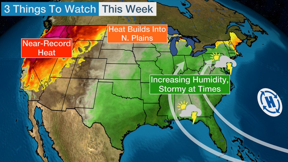
The South and East will turn warmer and more humid with increasing thunderstorm chances. Meanwhile, record heat could bake parts of the western and northern U.S.
 The green contour shows the increasing moisture and humidity in the East by late in the week
Below we step through an overview of this week's biggest weather stories to watch.
East: Warmer, More Humid With Increased Storm Chances
Memorial Day weekend was chilly for late-May standards in the East.
Highs in parts of the Northeast were stuck in the upper 40s or low 50s on Saturday and Sunday. New York City's high of 51 degrees on Sunday was the coldest high temperature ever recorded there this late into spring.
Dry air also pushed all the way into the Deep South, making for pleasantly low humidity and cool mornings.
But changes are ahead, with high pressure near Bermuda set to pump increasingly warm and more humid air into many parts of the southern and eastern U.S. as the week progresses. This should make for a noticeable flip to a more summerlike feel given the recent cooler pattern.
On top of that, upper-level disturbances tracking through the East will tap into the increased moisture. That will lead to a greater chance of scattered thunderstorms with locally heavy downpours during the second half of the week in both the South and East.

West: Record Heat Likely
The West is heating up and parts of the region will likely set record highs through the middle part of the week ahead.
An upper-level high-pressure system building into the Northwest will send temperatures 15 or more degrees above average for this time of year.
Portions of California, Oregon, Washington, Nevada, Idaho, Utah and Montana could all see high temperatures approach daily record highs at times this week. Sacramento, California; Reno, Nevada; Boise, Idaho; and Salt Lake City, Utah, are some of the cities that might see record heat.
See this link for more details on the record-breaking heat this week.
 Forecast Highs
Northern Plains: Record Heat Possible
The heat in the West will eventually spread into the north-central U.S. by late in the week ahead.
Minneapolis-St. Paul and Fargo and Bismarck, North Dakota, could see their first 90s of the year by later in the week or next weekend. That means temperatures will be 15 or more degrees above average for early June standards.
In fact, several cities in the Dakotas and Minnesota could approach daily record high temperatures Friday into next Saturday.
 Forecast Highs Late This Week
The Weather Company’s primary journalistic mission is to report on breaking weather news, the environment and the importance of science to our lives. This story does not necessarily represent the position of our parent company, IBM.
The Weather Company’s primary journalistic mission is to report on breaking weather news, the environment and the importance of science to our lives. This story does not necessarily represent the position of our parent company, IBM.

No comments:
Post a Comment