Wednesday, March 31, 2021

Spring temperatures are on the rise across major US cities: What are the impacts?

 By Lauren Fox, AccuWeather staff writer

Published Mar. 20, 2021 3:09 PM EDT


As Americans eagerly await for spring temperatures to loosen winter's icy grip, new data suggests that many major U.S. cities could see warmer-than-normal temperatures -- a trend that has been consistently documented for the past 50 years.

An analysis of 243 cities across the U.S. conducted by Climate Central, a nonprofit news organization that focuses on climate science, revealed that nearly half of the cities have recorded higher spring temperatures of 2 degrees Fahrenheit or more over the past half-century. Of the 243 cities, 120 of them, or 49%, have seen this trend -- which can ultimately lead to an earlier wildfire season, decimated crops and can impact food supply.

In addition, 96% of the cities included in the analysis reported an increase in the amount of above-normal days for spring temperatures since 1970. Meanwhile, 81% of the cities have reported at least five more days above normal yearly.

“How much that increase in warmth has occurred is variable from region to region,” Theresa Crimmins, director at USA National Phenology Network, told AccuWeather. “In some regions of the country, we’re seeing a much stronger trend toward more warmth earlier in the year.”

According to Crimmins, the southwestern U.S. is in part where some of the most dramatic trends of early warmth in recent years has occurred.

Cherry blossoms, like the ones shown above alongside the Arlington Memorial Bridge in Washington, D.C., are one of many plants that respond biologically to rising spring temperatures across the U.S.(Photo/GettyImages/uschools)

“In the Southeastern part of the country it's a messier story really,” Crimmins said. She explained that a portion of the country is actually experiencing what she referred to as a “warming hole,” meaning the pattern of warming seen across much of the U.S. is not as prevalent in the region. 

The northern Plains is the only portion of the U.S. to actually be trending cooler instead of warmer in the spring, according to AccuWeather Senior Meteorologist Bob Smerbeck.

The Dallas-Fort Worth area has reportedly had 15.7 more spring days above normal temperature in 2020 than in 1970, and the average temperature for spring has increased by 2.9 degrees.

Houston, Texas, which is over 200 miles south of Dallas, has warmed nearly a full degree more than the Dallas-Fort Worth area, increasing in average temperature by 3.8 degrees from 1970 to 2020. The city of Houston had 23.6 more above-normal spring days in 2020 than it did 50 years prior.

Smerbeck suggests that for some cities, the proximity to cool water may play a role in their ability to maintain cooler temperatures longer.

While it does not apply to Houston due to warmer waters in the Gulf of Mexico in springtime, cities along the coast in the eastern U.S. and the West Coast can be cited as prime examples of how cool waters can play a role in local spring temperatures.

Take Philadelphia and New York City, for example.

Philadelphia's average spring weather has warmed by 2.7 degrees since 1970, and the city reported 11.9 more days above normal during the spring of 2020 than in 1970. Despite being less than 100 miles apart, New York City's warming trend has been significantly less impressive than the one in Philadelphia, the former only reporting 2.2 more days above normal during the spring of 2020 compared to 50 years prior, and increasing in average spring temperature by one degree.

"The difference between Philadelphia and New York City could be that New York City is closer to the chillier ocean at this time of year and it can keep it cooler in the spring," Smerbeck said. "Another factor is how fast cities are expanding with asphalt and concrete causing urban heat island. Houston is an example of this."

According to Crimmins, some research suggests that urban areas experience the heat more-so than rural areas with less development.

Cities along the Pacific Ocean, such as Los Angeles, have also reported much more minimal growth in warmth, which Smerbeck said could be due to the cooler waters in the Pacific as well.

While many Americans are surely looking forward to soaking up the sun for as long as possible, an extended warm season has natural impacts.

FILE - In this June 27, 2020, file photo, a lifeguard keeps watch over a packed beach in Huntington Beach, Calif. The Los Angeles County Department of Public Health is ordering L.A. County beaches closed from July 3 through July 6 at 5:00 a.m. to prevent dangerous crowding that results in the spread of deadly COVID-19. (AP Photo/Marcio Jose Sanchez, File)

Crimmins explained that when the weather warms up earlier in the year, it creates a biological response within the environment that starts earlier in the year as well and inevitably results in a shorter winter overall for the region.

While this could initially sound more pleasant to people who love warmer weather, it can result in a longer allergy season for people who suffer from pollen allergies. The early start to pollen season can account for more trips to the emergency room as a result of uncontrolled asthma. 

Smerbeck said the early warmth can also potentially turn dangerous, as it can trigger an easier start to wildfire season in the Southwest and Great Basin as the regions get hotter and drier. He said an earlier start to fire season is forecast for those regions this year as well.

FILE - In this Sept. 9, 2020, file photo, the San Francisco skyline in the distance behind Crissy Field is barely visible due to smoke from wildfires burning across California. Researchers say smoke from wildfires accounted for up to half of all small particle air pollution in parts of the western U.S. in recent years (AP Photo/Eric Risberg, File)

Early warmth followed by freezing temperatures can also devastate crops.

Apples and cherries, for example, produce flower buds before they produce leaf buds. If the flower buds develop and then are hit by frost, the fruit is no longer able to develop, whereas if the leaf buds are hit by frost the trees can usually bounce back by producing another round of leaves. 

“When we have frost hitting flower buds, that can be really devastating,” Crimmins said. “In some recent years, we’ve had huge impacts to fruit crops as a consequence of early warmth followed by freezing temperatures."

In 2017, the entire southeastern United States and a good portion of the eastern U.S. experienced record setting early warmth into the spring season. The peach crop in Georgia was particularly affected by the record warmth, as the flower buds came out early and were harmed by the following weather conditions.

"I think the crop was decimated by something like 80 or 90%," Crimmins said.

Smerbeck has also experienced firsthand how early warmth followed by cold temperatures can impact plant growth and said he has had hyacinths blossom ahead of schedule and ultimately get wiped out by a freeze three out of the last four springs.

“We also see consequences where species that depend on each other to be active at the same time are not responding to the increasing warmth to the same degree,” Crimmins said.

This is creating what she described as “biological mismatches,” where for example a plant that requires a specific pollinator is not responding to the warmth in the same way the pollinator does, putting the plant species at a disadvantage. 

FILE - This Feb. 17, 2021 file photo shows an empty irrigation canal at a tree farm in Corrales, N.M., with the Sandia Mountains in the background, as much of the West is mired in drought, with New Mexico, Arizona, Nevada and Utah being among the hardest hit. The National Oceanic and Atmospheric Administration’s official spring outlook Thursday, March 18, 2021, sees an expanding drought with a drier than normal April, May and June for a large swath of the country from Louisiana to Oregon. including some areas hardest hit by the most severe drought. And nearly all of the continental United States is looking at warmer than normal spring, except for tiny parts of the Pacific Northwest and southeast Alaska, which makes drought worse. (AP Photo/Susan Montoya Bryan)

Aside from the economic impacts and food availability concerns associated with destroyed crops, Crimmins said there are also more social impacts to the shift in temperatures for the spring -- particularly with seasonal festivals such as the annual cherry blossom festivals in Washington, D.C. The nation's capital has reported 5.7 more days above normal temperatures in spring 2020 compared to spring 1970.

"Tulip Time festivals or lilac festivals or even cherry blossom festivals can be impacted when the dates are set far in advance and the biological event is very responsive to the weather conditions in a given year," Crimmins said. "We've seen that in a couple recent years."

As for the upcoming season, AccuWeather forecasters have spelled out what you can expect for temperature trends along with other weather factors this spring.

RELATED:

Keep checking back on AccuWeather.com and stay tuned to the AccuWeather Network on DirecTV, Frontier, Spectrum, FuboTV, Philo, and Verizon Fios.

U.S. Avalanche Deaths Tied for Highest Number in 70 Years

 Jan Wesner Childs

Published: March 31, 2021


Thirty-six people have died in avalanches in the U.S. since Dec. 18, according to the Colorado Avalanche Information Center. That ties the highest number ever recorded in any season dating back to 1950.

Only two other seasons since 1950 have seen as many avalanche deaths – 2007-08 and 2009-10.

This year’s deadly conditions started with early-season snowfall, followed by a dry spell. That created in the snowpack what experts call a persistent weak layer, buried under subsequent layers of snow as winter kicked into full gear.

"And then it’s like a house of cards," Jim Donovan, emergency management director in San Juan County, Colorado, told weather.com.

A skier, a snowmobiler, a hiker – any movement – can cause the weak layer to fail and send layers of snow careening down a slope, carrying and burying anything and anyone in its path.

Donovan, who also heads up the Silverton Avalanche School, is one of several avalanche experts who spoke to weather.com about this year's historic season and the weather that brought it about.

(WATCH: Utah Avalanche Caught on Camera)

Temperature gradients in the snowpack caused that early layer of snow to go through a process called faceting, which weakens snow and turns it to a granular consistency that doesn’t stick together, explained Mike Cooperstein, an avalanche forecaster at the CAIC.

Commonly called “sugar snow,” it's more the consistency of salt.

"By itself, it’s not a big deal. But then when you put more snow on top of it, when you put an additional load on top of it, that weak, sugary snow down near the ground can’t support the load of snow on top," said Greg Gagne, a forecaster at the Utah Avalanche Center. "It’d be like trying to build a house on top of a foundation made of sand. It’s just a very unstable structure."

Such conditions aren't unusual on a local level.

"We see this maybe every 10 years," Donovan said. "But what was unique [this season] was that it was so widespread."

The persistent weak layer was in play across much of the western U.S., contributing to avalanches in states including Colorado, Wyoming, Montana, Utah and Idaho.

One of two deadly avalanches in Donovan’s county left three victims buried under as much as 20 feet of snow. Volunteer search and rescue teams worked for days to dig them out.

The victims are among 12 killed in Colorado, which also ties a record.

(MORE: Latest Winter Weather Forecast)

Simon Trautman, an avalanche specialist at the National Avalanche Center, said another unique thing about this season is that the threat never really subsided.

"You have direct action avalanches as the danger is rolling through but then you also have this period of latent danger that can continue for quite some time," Trautman said. "So what happened this year was the danger didn’t really drop between storms, it just stayed high."

The center maps avalanche risk on its website at Avalanche.org. Orange means there is considerable danger. Red means high.

"During February, that whole map was elevated," Trautman said. "It was either orange or red for the entire time."

The first death of the season came when a 41-year-old snowmobiler named Brandon Jones triggered an avalanche in the Salt River Range near Afton in western Wyoming, one week before Christmas.

It happened on a slope known to locals as "Suicide Mountain."

report by the Bridger-Teton Avalanche Center, one of 14 backcountry avalanche information and education centers run by the U.S. Forest Service, singled out a persistent weak layer formed after snow that fell in mid-November was followed by about three weeks of dry conditions before more snow accumulated.

The most recent death was March 27 near Matanuska Glacier northeast of Anchorage, Alaska. Erin Lee, 40, was skiing the backcountry when she was killed.

The deadliest incident was Feb. 6 in the Mill Creek Canyon area outside of Salt Lake City when seven backcountry skiers from two different groups were caught up in a slide. Survivors worked frantically to dig out those buried in the snow, according to a report from the CAIC. Four people died. Two others were pulled out alive.

(MORE: Avalanche Deaths On The Rise)

The conditions we saw this year could be a window into future winters under the influence of climate change, according to Dr. Jordy Hendrikx, director of the snow and avalanche lab at Montana State University.

Hendrikx said it would take extensive research to specifically link the conditions to climate change, but they are in line with what is expected as temperatures increase and weather patterns shift.

"And what I mean by that is that we are seeing longer periods of low to no precipitation, so longer periods of drought, followed by more extreme periods of precipitation thereafter. It’s consistent with the types of behaviors that we expect to see in a future climate," Hendrikx said.

"It’s really been the perfect storm of meteorological conditions to lay this foundation."

Hendrikx finds avalanches to be unique among weather-related disasters because they are most often triggered by human decisions. They're different than earthquakes in California, for example, where there is almost a constant risk and little residents can do to avoid the threat.

"Whereas in the case of avalanches we see that in 90% of cases where there’s a fatality either the person that was killed or a member of the person’s group triggered that avalanche," Hendrikx said. "So what that means is that we as humans and our decisions we make and how we use terrain and how we choose to expose ourselves has a direct connection to the ultimate outcome and the consequence."

As is usual, most of the 36 people killed in avalanches this season were in backcountry areas, which are often located on public lands like national forests or similar wilderness areas. Avalanches are rare in ski resorts because the private entities that own them carry out extensive monitoring and mitigation actions, including triggering avalanches to clear the risk.

Skiers, especially, are attracted to the backcountry despite the risk.

"You’re just flowing down the mountainside in snow that is knee-deep, waist-deep," Gagne said. "All the noise in your life, everything just shuts off, and you’re just focusing on just using gravity flowing downhill. It’s a euphoric feeling."

At the beginning of the season, there were concerns that more people would be killed in the backcountry this year due to an influx of inexperienced people seeking more open spaces in the wake of the coronavirus pandemic. That hasn't been the case – many, if not most, of those killed were well-versed in the dangers of trekking into the snow-covered wild.

Often they were equipped with the recommended gear – a beacon, probe, shovel and, in some cases, an avalanche air bag – and had training in how to spot and navigate through avalanche terrain.

But as Gagne points out, there’s a saying: "Everyone knew you were an expert, except the avalanche."

"I like that because it’s basically saying you cannot outsmart it," he said. "At the end of the day, the snow’s going to have its way."

The Weather Company’s primary journalistic mission is to report on breaking weather news, the environment and the importance of science to our lives. This story does not necessarily represent the position of our parent company, IBM.

The Weather Company’s primary journalistic mission is to report on breaking weather news, the environment and the importance of science to our lives. This story does not necessarily represent the position of our parent company, IBM.


April Fools' Snow in Interior Northeast to Be Followed By Blast of Colder Air in East

 Chris Dolce

Published: March 31, 2021


Low pressure along a sweeping cold front will bring snow to the interior Northeast on April Fools' Day, followed by a brief blast of near record-low temperatures in parts of the East.

Rain is expected to mix with or change to snow Wednesday night into early Thursday from northern Vermont and western and central New York to possibly as far south as the central and southern Appalachians.

Areas near the Eastern Seaboard will see soaking rain, from much of Maine to the mid-Atlantic and Southeast.

Article imageCurrent Radar

The low will continue to produce snow and gusty winds from northern New England into the central Appalachians on April Fools' Day. Snow might linger into Thursday night in far northern New England.

Activewear on Sale Now at Nordstrom Rack (SPONSORED)

Rain will exit during the daytime in coastal areas of the Northeast, followed by blustery conditions.

Article imageThursday's Forecast

The best chance for up to 6 inches of snow will be from central New York into the Adirondack Mountains and northern Vermont. Scattered power outages are possible in these areas given the heavy, wet nature of the snow.

Lighter accumulations of snow could also coat other areas farther to the south from western New York and northern Pennsylvania to the central Appalachians in West Virginia.

Burlington, Vermont, and Syracuse, New York, are among the cities that could see wet snow accumulations.

April snow is not uncommon in these cities. Both of those locations average a few inches of snow in the month, according to the 30-year average (1981-2010) from NOAA.

Snowfall is more than four feet below average this season in Syracuse, but this late-season system will barely make a dent in that deficit.

Article imageSnow and Rain Forecast

Temperatures Could Approach Daily Record Lows

April will also start rudely for a much broader area of the East as a plunge of colder air moves in behind the snowmaker.

Low temperatures will be 10 to 20 degrees below average from the Ohio Valley and mid-Atlantic into the Southeast by Friday morning. Some locations could approach daily record lows for April 2.

A​ll Things Outdoor on Sale Now at Wayfair (SPONSORED)

Binghamton, New York, Asheville and Wilmington, North Carolina; and Columbia, South Carolina, are a few of the cities that could come within a few degrees of daily record lows on Friday morning.

But this chilly blast won't stick around for long. After a cold Saturday morning, temperatures will be on a gradual warming trend in the East through the weekend.

Article imageFriday AM Forecast Lows

The Weather Company’s primary journalistic mission is to report on breaking weather news, the environment and the importance of science to our lives. This story does not necessarily represent the position of our parent company, IBM.

The Weather Company’s primary journalistic mission is to report on breaking weather news, the environment and the importance of science to our lives. This story does not necessarily represent the position of our parent company, IBM.

April Can Bring a Variety of Weather, Including Tornadoes, Snow and Even Tropical Storms

Linda Lam
Published: March 31, 2021


April often brings a variety of weather conditions as winter tries to hang on and temperatures warm up.

The collision of seasons can lead to severe storms, flooding and snow. Tropical storms have even formed in the Atlantic in April.

Here's a closer look at what has occurred in the weather in April.

Warmer Temperatures Finally Emerge

From the beginning to the end of the month, many locations experience a noticeable jump in average temperatures. New York City sees its average high rise from 56 degrees on April 1 to 66 degrees on April 30. The average high in Minneapolis increases from 50 degrees to start the month to 65 degrees to close it out. Average lows here also rise from the lower 30s to the mid-40s during April.

By the end of April, the South, mid-Atlantic, Ohio Valley and parts of the central Plains have generally experienced their last freeze of the season. Much of the Northeast, upper Midwest and Intermountain West wait until mid-May or later to see the last freeze.

Get Your Patio Ready for Spring with these Outdoor Tables (SPONSORED)

But not every April is dominated by spring warmth. Below-average temperatures dominated April 2020 for much of the Midwest and Northeast. April 2018 was the 13th-coldest on record in the contiguous United States; Iowa and Wisconsin both shivered through their coldest April on record.

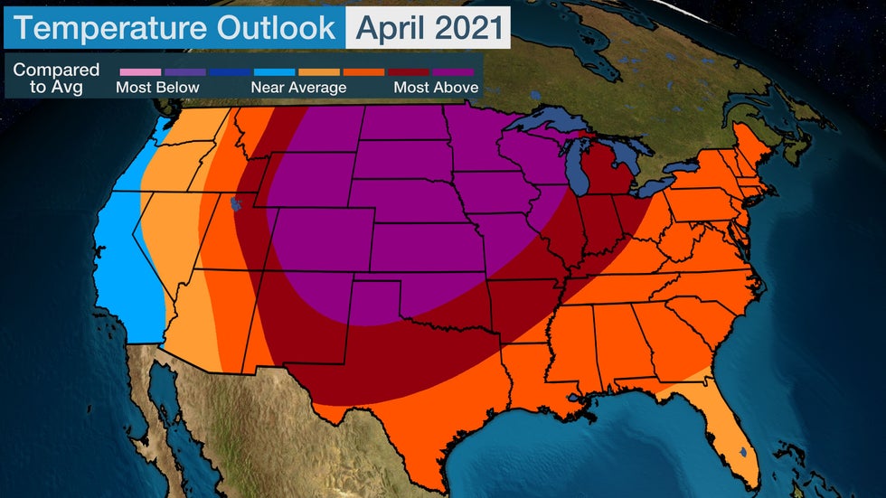
This April, most of the country is expected to see warmer than average temperatures, especially across the central U.S.

(MORE: April 2021 Temperature Outlook)

Article imageApril 2021 Temperature Outlook

Tornado Risk Increases

As temperatures rise, moisture increases and thunderstorms become more common. The risk of tornadoes also increases as the ingredients for severe weather are more often in place.

Tornado outbreaks often occur when a low-pressure system accompanied by a strong, southward dip in the jet stream punches into the Plains, Midwest or South. In addition, warm and humid air flows northward out of the Gulf of Mexico.

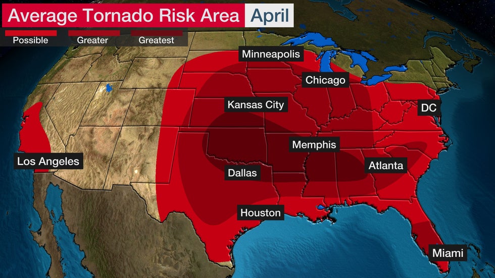
In April, the tornado threat is highest from southeastern Kansas, Oklahoma and northern Texas eastward into parts of Alabama.

Top Rated Office Chairs Starting at $70 (SPONSORED)

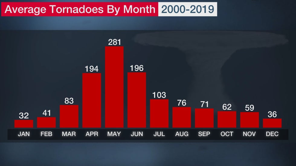
April is typically the third-busiest month for tornadoes, with May and June coming in first and second, respectively. April 2011 set a record for most tornadoes in any month with 758, due in large part to the April 26-28 super outbreak.

A couple of severe weather outbreaks have already occurred in March this year. Last April was very busy and included a tornado outbreak on Easter. So now is a good time to get prepared for severe weather.

Article imageTypical Tornado Risk in April

More Rain Can Lead to Flooding

April is often an active weather month with low-pressure systems tracking across the U.S.

These low-pressure systems can bring rounds of rain which, when combined with snowmelt due to the warming temperatures, can result in river flooding. In addition, flash flooding is also a more widespread concern as thunderstorms become more common.

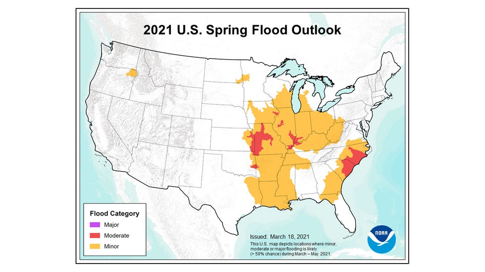
Limited moderate flooding is anticipated this year, according to NOAA's spring flood outlook, and no areas have a greater than a 50% chance of major flooding for the first time in three years. Areas of greatest concern for spring flooding this year include parts of the lower Missouri and lower Ohio river basins and the coastal plain of the Carolinas.

S​hop the Nordstrom Spring Sale (SPONSORED)

Precipitation this April is generally expected to be near or below average for much of the U.S., especially across parts of the South and West. Abnormally dry conditions stretch across more than half of the Lower 48, according to the U.S. Drought Monitor, so the drier-than-average trend could lead to an expansion of drought this spring while limiting flood concerns.

Article imageSpring Flood Outlook

It Can Still Snow

Although temperatures increase in April, snow is still possible, especially in the higher elevations of the West.

There are a few spots where April is the snowiest month. These include Breckenridge, Colorado; Casper, Wyoming; and Mount Rushmore, South Dakota. Denver can also experience some of its heavier snowfalls in April.

Snow from Winter Storm Sadie blanketed areas from the Rockies into parts of the Midwest and Northeast in mid-April 2020. This was the third-biggest snowfall so late in the season for Providence, Rhode Island.

In 2018, the record-breaking cold in April helped to set new snow records. In mid-April, Winter Storm Xanto brought 15.8 inches to Minneapolis/St. Paul, making it the heaviest April snowstorm on record there. Xanto was also the heaviest April snowstorm in Green Bay, Wisconsin, where 24.2 inches accumulated and blizzard conditions were observed.

This year, snow is expected to start the month in parts of the interior Northeast.

Article imageThe average snowiest month in areas that typically pick up over 3 inches of snow each year, based on 1981-2010 average snowfall data.

Tropical Storms Can Develop in the Atlantic

Although the Atlantic hurricane season officially begins June 1, tropical cyclones sometimes develop before then.

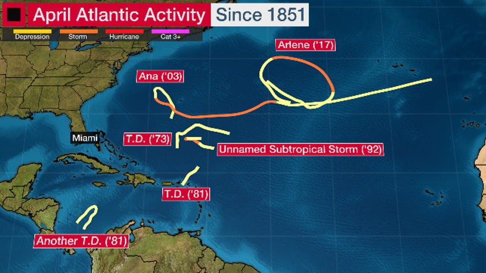
Two tropical storms have developed in the Atlantic in April. Ana formed in 2003, and Arlene occurred in 2017. A subtropical storm also developed in April 1992. There are no Atlantic hurricanes on record during April.

Conditions are often not favorable for tropical development in April, but sometimes an area with the right environmental conditions emerges and a tropical cyclone can form.

S​pring is on Sale at Nordstrom (SPONSORED)

Preseason tropical systems are frequently lopsided and fairly shallow in height.

In 2020, the Eastern Pacific Basin recorded its first tropical depression in April, based on reliable records since weather satellites began regularly watching the tropics in the late 1960s. Tropical Depression One-E was short-lived and did not impact land.

Article imageTracks of April Atlantic Basin tropical cyclones in records dating to 1851.

The Weather Company’s primary journalistic mission is to report on breaking weather news, the environment and the importance of science to our lives. This story does not necessarily represent the position of our parent company, IBM.

The Weather Company’s primary journalistic mission is to report on breaking weather news, the environment and the importance of science to our lives. This story does not necessarily represent the position of our parent company, IBM.

April Starts the Most Dangerous Three Months For Tornadoes in the U.S.

 Chris Dolce

Published: March 31, 2021


April kicks off what is typically the most active and dangerous three months of the year for tornadoes in the United States.

As 2021 has already proven, damaging tornadoes can strike in any month. March had a series of severe weather outbreaks in the South, but deadly tornadoes also struck the region in January and February.

But weather history shows April, May and June are the months with the most potential of having both the greatest number of tornadoes and the most intense tornadoes.

The U.S. averaged 1,234 tornadoes annually from 2000 to 2019. About 54% of those tornadoes happened from April to June.

The most tornadoes typically happen in May, with an average of 281. This is followed by June and April, which average 196 and 194 tornadoes per year, respectively.

Article imageApril-June average the most number of tornadoes during the year.

Of course, these are averages and the actual outcome can vary for how tornadic these months are in a given year. Last year is a good example of this.

Following one of the most active Aprils on record, May and June went mostly silent in 2020.

S​hop the Spring Sale at Nordstrom (SPONSORED)

Just 10 tornado watches were issued in May 2020, the fewest for the month in 50 years of records, according to NOAA's Storm Prediction Center. The preliminary tornado count for May was less than half of the 20-year average.

An Easter outbreak in April 2020 spawned more tornadoes in two days (140) than the preliminary total for both May and June.

Tornado Threat Migrates From South to Plains, Midwest

Tornadoes are more common in spring compared to other months because the required atmospheric ingredients come together more often this time of year.

Outbreaks of tornadoes occur when a storm system propelled by a strong, southward dip in the jet stream punches into the Plains, Midwest or South. This is accompanied by warm and humid air flowing northward out of the Gulf of Mexico.

Historically, the greatest threat of tornadic thunderstorms has migrated from the South into parts of the Plains and Midwest as the year progresses deeper through spring and into early summer.

The reason for this is that the jet stream begins to make its annual northward retreat toward the Canadian border. The jet stream provides deep wind shear, or changing wind speed and direction with height, supportive of rotating supercell thunderstorms.

If wind shear is particularly strong in the first few thousand feet near the surface, these supercells would more likely produce tornadoes.

That's why the potential for tornadoes in the South is much lower in June compared to April. Although moisture is abundant across the southern region in late spring, the strong jet stream needed to help make conditions favorable for tornadic thunderstorms is usually absent.

(MORE: Tornado Risk By Month)

Article imageAverage tornado risk for April, May and June.

Tornado Intensity Is a Factor in Spring, Too

The sheer number of tornadoes from April through June isn't the only thing that makes this such a dangerous time of year – tornado intensity is also a factor.

About 58 percent of all twisters rated F3/EF3 or stronger (1950-2012) touched down in those three months, according to statistics compiled by Dr. Greg Forbes, a former severe weather expert for The Weather Channel. This rises to 69 percent when examining tornadoes F4/EF4 or stronger.

Shop O​utdoor Dining Sets Starting at $150 (SPONSORED)

The most violent F5/EF5 rating has been assigned to 59 tornadoes dating back to 1950, and all but 10 of those occurred in April, May or June.

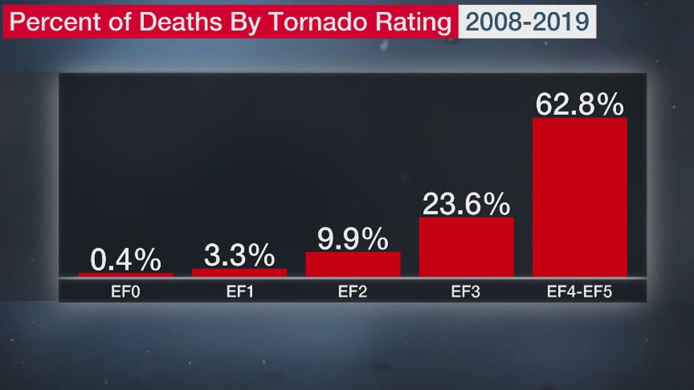
All tornadoes pose a threat, but intense twisters account for a higher number of fatalities and damage. About 86 percent of the deaths from 2008 through 2019 were from tornadoes rated EF3 or stronger, according to NOAA's Storm Prediction Center.

Article imageThe largest percentage of tornado deaths are caused by twisters rated EF3-EF5.

The Weather Company’s primary journalistic mission is to report on breaking weather news, the environment and the importance of science to our lives. This story does not necessarily represent the position of our parent company, IBM.

The Weather Company’s primary journalistic mission is to report on breaking weather news, the environment and the importance of science to our lives. This story does not necessarily represent the position of our parent company, IBM.

Man missing at sea for nearly 2 weeks found alive in life raft off Washington coast

  One of two men missing at sea for nearly two weeks was found alive on Thursday by a Canadian fishing boat in a life raft in Canadian water...