Jonathan Erdman
 Capital One Bank Tower is seen with its windows blown out in the downtown area of Lake Charles, Louisiana, after Hurricane Laura passed through on Aug. 27, 2020.
Each year we compile a list of America's most extreme weather cities of the past year by combing through temperature and precipitation data.
But in 2020, the data didn't necessarily tell the story of which cities were hit hardest by extreme weather.
Lake Charles, Louisiana, was devastated by Hurricane Laura's 100-plus mph winds, then hit a second time by Hurricane Delta six weeks later.
Several towns in California, Oregon and Washington were scorched by wildfires in 2020.
Nevertheless, with help from the Southeast Regional Climate Center (SERCC) and the National Weather Service, we culled through reporting stations with at least a 60-year period of record without significant missing data to find out which places were the warmest, coolest, wettest and driest in 2020, relative to average conditions.
A number of cities were record warm. Others were record wet or dry. No locations were record cold.
(MORE: 10 Broken Records That Blew Our Minds in 2020)
The Warmest
If we listed the warmest cities based on straight temperatures, it would be obvious. Puerto Rico, the U.S. Virgin Islands, Hawaii, South Florida, South Texas and the Desert Southwest would lead the pack every year. Boring, right?
Instead, we examined the anomalies, or departure from average temperatures. The more often temperatures were above average and the higher those departures were above average, the greater the anomaly over the year.
There were plenty of warm outliers to choose from in 2020.
At least 23 cities in the East, near the Gulf Coast and in parts of the West tied or set a record warm year in 2020.
Seven of those cities, Miami, Ocala and Sarasota, Florida; Savannah, Georgia; Hatteras, North Carolina; Norfolk, Virginia; and Kahului, Hawaii; sizzled through a record warm year for the second year in a row.
Miami's six warmest years and New Orleans' eight warmest years have all occurred since 2011.
Other cities with a record warm year in 2020 included Harrisburg and Scranton, Pennsylvania; Hagerstown, Maryland; Brownsville, Texas; and Hilo, Hawaii.
(MORE: Strangest Weather of 2020)
 Cities that tied or set new record warm years in 2020 are plotted in the map above. The contours show general areas of increasing temperature departures from average in the year, with the areas most above average shown in the peach and red contours.
Through November, NOAA found 2020 was the fourth warmest year-to-date in the U.S. in records dating to 1895, and was record warm in Delaware, Florida, Maryland and Virginia. NOAA's final 2020 U.S. report was due to be released on Jan. 7.
Top U.S. 2020 Warm Temperature Anomalies (Source: SERCC)
-Hatteras, North Carolina: +4.3 degrees
-Scranton, Pennsylvania: +4.3 degrees
-Sandberg, California: +4.2 degrees
-Baker City, Oregon: +4.0 degrees
-Elizabeth City, North Carolina: +3.9 degrees
The Coolest
In one of the nation's warmest years on record, it was a challenge to find any locations that were cooler than average, as the map below illustrates.
Virtually the entire Lower 48 was warmer than average. The only larger areas colder than average in North America were in central and southern Alaska eastward into northern Canada.
 Surface temperature departures from 1981-2010 average, in degrees Celsius, over North America and adjacent areas in 2020, through Dec. 27, the most recent day the year-to-date analysis was available at the time this article was published.
Besides Alaska, there were also some cooler pockets in parts of the nation's mid-section, where hot domes of high pressure were less prevalent in 2020 than along the West and East Coasts.
Oklahoma City was cooler than average for seven months in a row from April through October, which led to a strangely quiet spring for tornadoes and was punctuated by an unusual October ice storm, then another round of ice on New Year's Eve.
 A large tree lays broken in half on west Cherokee in Enid, Oklahoma, Wednesday, Oct. 28, 2020, following an ice storm.
Top U.S. 2020 Cool Temperature Anomalies (Source: SERCC)
-Bluefield, West Virginia: -1.8 degrees
-Kenai, Alaska: -1.3 degrees
-Bozeman, Montana: -1.2 degrees
-Talkeetna, Alaska: -1.1 degrees
-Oklahoma City: -1.0 degrees
The Wettest
The Southeast U.S. is typically one of the wettest regions of the country, with nearby reservoirs of moist air to tap from the Gulf of Mexico and Atlantic Ocean, not to mention visits from tropical cyclones and their remnants.
But 2020 easily cleared this high bar, with yearly precipitation at least 10 inches above average from parts of Ohio and the mid-Atlantic states to South Florida to Arkansas.
 2020 precipitation departures from average nicely illustrate the much wetter than average year through much of the Southeast U.S., with some departures over 20 inches.
We counted over 40 U.S. reporting stations with 2020 precipitation surpluses of at least 20 inches, almost entirely from Florida to Virginia.
Among some of these cities were Chattanooga, Tennessee (just over 20-inch surplus); Columbus, Georgia (over 22-inch surplus); and Greenville, South Carolina (over 26-inch surplus).
But we found five even larger wet anomalies.
Top U.S. 2019 Wet Anomalies (Source: SERCC)
-Brevard, North Carolina: +38.13 inches
-Hickory, North Carolina: +34.38 inches
-Ketchikan, Alaska: +33.85 inches
-Fort Lauderdale, Florida: +33.17 inches
-Lincolnton, North Carolina: +30.70 inches
At least 13 locations in Mississippi, North Carolina, Tennessee and Virginia had their record wettest year in 2020.
 Cities that set a record wet year in 2020 included Houston, Mississippi; Cleveland, Greeneville and Monteagle, Tennessee; and Lynchburg and Roanoke, Virginia.
Hickory, North Carolina, picked up over 80 inches of precipitation in 2020, which crushed its previous record wettest year set just seven years ago (66.87 inches), by over 13 inches. It was as if they picked up more than an extra summer's worth of rain. They average 12.61 inches of rain from June through August.
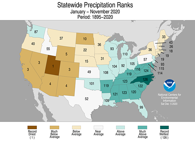
Through November, NOAA found 2020 to be the wettest year-to-date in North Carolina in records dating to 1895.
Lynchburg and Roanoke, Virginia, each also shattered their annual precipitation record, set just two years ago in 2018.
A mid-May storm dumped over 8 inches of rain in Roanoke, their heaviest three-day rain event since 1987, which pushed the Roanoke River almost 6 feet above flood stage.
The Driest
As 2020 kicked off, drought was relatively limited. But by year's end, drought was widespread from the Plains into the West, reaching exceptional levels from West Texas to Nevada.
So it's no wonder the largest precipitation deficits in 2020 were generally in the western half of the country.
San Francisco (7.79 inches) only picked up one-third of its average annual rain in 2020, its second driest year in records dating to 1850. Only 2013 (5.59 inches) was drier in the Bay Area.
The combination of parched ground, winds and some summer thunderstorms triggered a rash of destructive wildfires in California, Oregon and Washington in late summer.
Other parts of the West had their driest year on record in 2020.
Summer monsoon thunderstorms that largely didn't materialize - referred to colloquially as the "nonsoon" - allowed both Flagstaff and Tucson, Arizona, to each set new dry year records. It was the first year on record Tucson failed to pick up at least 5 inches of precipitation, a record that had stood for 96 years.
In Wyoming, Casper, Laramie and Rawlins each set new record dry years, with each city failing to pick up half their average annual precipitation in 2020.
Baker City, Oregon; Carlsbad, New Mexico; and Dillon, Montana; also set record dry years in 2020.
Through November, NOAA found 2020 to be the driest year-to-date in Utah in records dating to 1895.
 The cities that set new their new record dry year in 2020, and the Dec. 29, 2020, Drought Monitor analysis. Areas of more serious drought were indicated in darker red and brown contours.
Other notable dry anomalies in 2020 could be found in the Plains, including Omaha, Nebraska (over 12-inch deficit), and Sioux Falls, South Dakota (about a 10-inch deficit).
Sioux Falls had back-to-back record wet years in 2018 and 2019, each topping 39 inches. They picked up less than half that amount in 2020, with just over 16 inches, among their top 10 driest years.
The other locations that filled out our driest cities' top-five list below included a Northern California city recently plagued by wildfires, as well as three wet towns along the Alaskan coast that missed out a bit more than usual on their typical soaking rain and snow.
Top U.S. 2020 Dry Anomalies (Source: SERCC)
-Yakutat, Alaska: -50.66 inches
-Cordova, Alaska: -30.00 inches
-Red Bluff, California: -15.83 inches
-San Francisco, California: -15.71 inches
-Kodiak, Alaska: -15.60 inches
The Weather Company’s primary journalistic mission is to report on breaking weather news, the environment and the importance of science to our lives. This story does not necessarily represent the position of our parent company, IBM.
The Weather Company’s primary journalistic mission is to report on breaking weather news, the environment and the importance of science to our lives. This story does not necessarily represent the position of our parent company, IBM.


No comments:
Post a Comment