Sunday, May 31, 2020

Amanda makes landfall, threatens major flooding in Central America

Updated May. 31, 2020 11:07 PM


After making landfall as a tropical storm on Sunday, Amanda turned deadly, and will continue to threaten the region with widespread flooding and dangerous mudslides as it nears the Atlantic Basin into midweek.

Before making landfall Sunday morning, the system strengthened into a tropical storm and was given the name Amanda, making it the first named storm of the 2020 East Pacific hurricane season.

By Sunday afternoon, Amanda was downgraded to a tropical depression and has since weakened to a tropical rainstorm. But forecasters say dangers from the storm have just begun, with torrential, life-threatening rainfall forecast to persist early this week.

A new round of torrential rainfall arrived in El Salvador and southern Guatemala on Sunday as Amanda moved inland. Officials in El Salvador issued an "Red Alert" and extended the state of emergency due to this surge of heavier rain.

As of Sunday night, there are reports of at least 14 deaths in El Salvador due to impacts from Amanda. In Guatemala, nearly 1,500 shelters have been opened for those affected by the storm.

Amanda is forecast to continue tracking to the northwest across Guatemala early this week. The rugged terrain has helped to rip the storm apart, but the remaining tropical moisture will continue to fuel heavy rain and thunderstorms across Central America through the beginning of the week.

Reports of flooding were already emerging from Costa Rica to end the weekend.

"Heavy rainfall will be the greatest threat over Central America, particularly in the higher terrain or Guatemala and El Salvador where rainfall totals of 18-24 inches are possible," AccuWeather Senior Meteorologist Randy Adkins said.

The highest terrain could pick up an AccuWeather Local StormMax™ of 800 mm (30 inches).

CLICK HERE FOR THE FREE ACCUWEATHER APP

"Heavy rainfall from Amanda will likely trigger not only flooding threats, but serious mudslides as well for portions of Guatemala and El Salvador early this week'" stated AccuWeather Meteorologist Mary Gilbert. "These mudslides can be very destructive and even life-threatening in nature as heavy rain continues to pound the area."

While Amanda will continue to lose wind strength, any locally strong wind gusts can knock over trees or power lines due to the saturated ground.

"Amanda is forecast to be a 1 on the AccuWeather RealImpact™ Scale for Hurricanes due to the risks posed by very heavy rainfall," Adkins said.

Amanda is forecast to move into the Bay of Campeche before the middle of the week and depending on the strength of the storm, it could set records.

"If Amanda were to survive and make it into the Bay of Campeche as a named system, it would be unprecedented," stated AccuWeather Meteorologist Courtney Travis. "The only tropical system to cross from the Pacific Ocean to the Atlantic Ocean Basin since 1950 was Hermine in 2010."

"However, Hermine was named in the Gulf of Mexico, having only reached tropical depression status in the East Pacific," she added.

This satellite image shows Amanda tracking across Central America as a tropical storm on Sunday afternoon, local time. (Photo/RAMMB)

Although tropical systems are usually shredded by the rough terrain of Central America when traveling from the East Pacific Basin to the Atlantic Basin, several storms have made this trek and dissipated then redeveloped once in the Atlantic Basin, according to Travis.

AccuWeather forecasters will be monitoring Amanda into the middle of the week and will continue to watch for potential tropical development through the early part of June as the developing weather pattern may keep the region active.

The same gyre that generated Amanda could be powerful enough produce additional tropical activity in the coming weeks.

"A tropical gyre is just a large slowly spinning area of disturbed weather, that can be as wide as a 1,500 km (1,000 miles) in diameter. When they form over Central America, they can create extra moisture to spawn tropical development on the Atlantic side or the Pacific side or sometimes both," said AccuWeather Senior Meteorologist Alex Sosnowski.

Because of this, AccuWeather meteorologists will also be monitoring the waters of the southern Gulf of Mexico and the western Caribbean very closely for tropical development through the middle of June.

Keep checking back on AccuWeather.com and stay tuned to the AccuWeather Network on DirecTV, Frontier and Verizon Fios.

Meteorological summer to start off with sizzling temperatures across the center of the country

Updated May. 31, 2020 11:05 PM


The same dome of heat that resulted in record-breaking temperatures across the West last week will shift eastward, bringing along summerlike conditions just in time for the start of meteorological summer.

From the central Rockies eastward to the Mississippi River Valley, temperatures ranging from 5-15 degrees Fahrenheit above average are to be expected through a majority of the week. Although millions of Americans across the nation will experience this June warmth, the core of the heat will target the Plains.

During the day on Sunday, temperatures in the 90s F sizzled portions of the High Plains. The heat, combined with a disturbance swinging through the northern Plains, helped to spark localized severe thunderstorms.

Throughout the week, rounds of showers and thunderstorms will generally target areas along the fringes of the hot weather.

While these localized showers and storms could provide a brief reprieve from the heat, air conditioning units will be working overtime across the center of the country this week.

Dodge City, Kansas, will be one of many cities scorching across the Plains. The current forecast has afternoon high temperatures topping out above 90 degrees through the entire week. The city's average high through the same time frame is 82-83 degrees, suggesting that the city could experience temperatures 10-15 degrees above average.

CLICK HERE FOR THE FREE ACCUWEATHER APP

An extended stretch of above-average temperatures can be expected in places like Denver, Kansas City, St. Louis and even into the Chicago metro area into midweek as the heat slowly shifts eastward.

On top of the scorching heat, many cities from the Plains into the Midwest will deal with very humid conditions as moisture is funneled northward out of the Gulf of Mexico. Combining these factors, AccuWeather RealFeel® Temperatures will climb even higher than what the mercury actually reads.

People spending time outdoors will want to make sure they stay properly hydrated and protected from the sun by wearing hats, sunglasses and sunscreen. If you must work outside, taking frequent breaks in the shade and drinking plenty of water or electrolyte beverages will greatly lower the risk of heat-related illnesses.

Amid the heat, remember to never leave children or pets in a sealed vehicle for any length of time. The temperature inside the vehicle can rise to lethal levels in a matter of minutes.

RELATED:

For portions of the Plains and mid-Mississippi Valley, this stretch of hot weather could extend through the week. Large-scale atmospheric conditions show hints of slightly lower temperatures compared to the midweek highs, but the forecast outlook looks likely that above-average warmth could continue into next week.

Keep checking back on AccuWeather.com and stay tuned to the AccuWeather Network on DirecTV, Frontier and Verizon Fios.

Gulf of Mexico an Area to Watch for Possible Development of a Tropical Depression or Storm This Week

Jonathan Erdman and Chris Dolce
Published: May 31,2020


A tropical depression or storm could form in the western Gulf of Mexico this week as the Atlantic hurricane season officially begins.

We've already checked Arthur and Bertha off this season's list, making this the sixth Atlantic hurricane season in a row with at least one named storm before the official June 1 kickoff. The next storm to form in the Atlantic Basin will be given the name Cristobal.

(MORE: Is An Active Hurricane Season Guaranteed After Two Early Storms?)

The National Hurricane Center has highlighted an area for possible tropical development in the southwestern Gulf of Mexico, as noted by the circle below. Currently, there is a medium chance of development in this area during the next couple of days, but those odds could increase or decrease in the week ahead.

Area to Watch

It remains too soon to determine where this potential system might track if it does form. There is a chance that it could remain stuck in the vicinity of the southwestern Gulf of Mexico, or it could eventually track northward through the western Gulf toward the United States.

Check back to weather.com for the latest on this potential tropical system. If anything, this is a reminder to refresh or develop your hurricane plan now.

Incidentally, we could be flirting with the record-earliest third named Atlantic storm, which is currently held by Tropical Storm Colin on June 5, 2016.

Potential Development Triggers: Amanda's Remnants and Central American Gyre

This tropical development may be spawned from something called a Central American Gyre, or CAG. This "gyre" is a large, broad area of low pressure that often forms in late spring and early fall over Central America and the western Caribbean Sea.

One such CAG has developed and will park itself over far southeastern Mexico and Central America through the week ahead.

The key here is that these CAGs can spawn tropical storms in the Caribbean Sea, Gulf of Mexico or Eastern Pacific Ocean.

Tropical Storm Amanda formed from this CAG in the Eastern Pacific near the coast of Guatemala over the weekend. Amanda dissipated over Central America on Sunday afternoon, but its leftover energy and spin could play a role in triggering tropical development in the southwestern Gulf of Mexico this week.

Current Satellite

One thing we know for certain is that there is a serious threat of flooding rainfall and mudslides in Central America and southern Mexico from the CAG and Amanda's remnants.

Flooding from this setup was reported in El Salvador on Sunday morning.

That National Hurricane Center says that 10 to 15 inches of rain (locally, 20 to 25 inches) could fall through the middle of this week in El Salvador, southern Guatemala, western Honduras and the Mexican states of Tabasco and Veracruz. Areas from northwestern Nicaragua and Belize to the Mexican states of Quintana Roo, Campeche, Chiapas and Oaxaca could receive 5 to 10 inches of rain.

(MORE: Central America, Mexico Tropical Cyclones Have a Deadly History)

Rainfall Forecast

Gulf of Mexico a June Hot Spot

June isn't one of the more active months of the hurricane season.

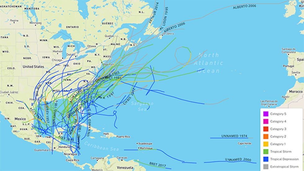
Since 1950, only 6% of all storms have formed in June, or an average of one storm every one to two years.

But many of those that do develop in June tend to do so in the Gulf of Mexico or western Caribbean Sea. They have also tended to move northward, meaning they eventually move ashore along the U.S. Gulf Coast.

Tracks of all June tropical depressions, storms and hurricanes from 1950 to 2019.

Most of these are either tropical depressions or tropical storms because they often don't have as much time to intensify before striking land, and they may be affected by wind shear early in the hurricane season.

Only a dozen of those June developing storms became hurricanes.

The last June hurricane in the Gulf of Mexico was Alex, which made landfall in northeastern Mexico on June 30, 2010, and brought flooding rain to Monterey, Mexico, and the lower Rio Grande Valley of Texas.

Warm water is another factor that may boost tropical development.

While not as warm as midsummer, Gulf of Mexico water temperatures are currently warmer than average for this time of year and warm enough to support tropical development. NOAA reported Gulf water temperatures shattered April records dating to 1910.

(MORE: Atlantic Hurricane Season Outlook)

Water Temperature Departures From Average

The Weather Company’s primary journalistic mission is to report on breaking weather news, the environment and the importance of science to our lives. This story does not necessarily represent the position of our parent company, IBM.

The Weather Company’s primary journalistic mission is to report on breaking weather news, the environment and the importance of science to our lives. This story does not necessarily represent the position of our parent company, IBM.


June Starts With Widespread Warmth, Pockets of Storms

Brian Donegan
Published: May 31,2020


The jet stream will shift northward to near the U.S.-Canada border this week.On Monday, high temperatures will be 10 to 20 degrees above average from the northern Rockies to the Northern Plains and upper Mississippi Valley. That translates to highs in the 80s and 90s for most areas.

The core of the above-average warmth will shift eastward toward the upper Midwest and Great Lakes on Tuesday, with many places running 15 to 25 degrees warmer than average. Widespread highs in the 80s and 90s are expected in those regions.

The hot temperatures will reach southern New England and the mid-Atlantic by Wednesday. Parts of those regions will be 5 to 15 degrees above average, translating to highs in the 80s and 90s. Washington, D.C., will make a run at 95 degrees Wednesday afternoon, which would be its hottest temperature so far this year. Philadelphia might reach 90 degrees for the first time in 2020.

Most of the Lower 48 will remain warmer than average through the end of the week as this weather pattern remains locked in place.

Forecast Highs Compared to Average

As mentioned earlier, pockets of thunderstorms will ride the jet stream along the northern tier of the nation.

On Monday, a few severe storms with damaging winds and large hail are possible in parts of the northern High Plains and the upper Mississippi Valley.

There's a better chance of scattered severe thunderstorms on Tuesday across the upper Midwest. Damaging wind gusts and large hail are the main threats there.

Tuesday-Tuesday Night Severe Thunderstorm Forecast

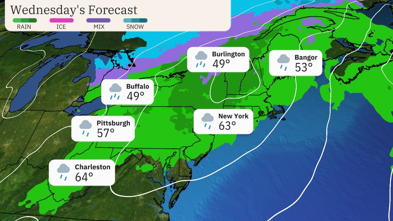
Additional strong to severe storms are possible on Wednesday from the mid-Mississippi and Ohio valleys to the mid-Atlantic.

The exact details on Wednesday's severe threat remain uncertain since it's a few days away, so check back to weather.com for updates.

Wednesday's Forecast

The Weather Company’s primary journalistic mission is to report on breaking weather news, the environment and the importance of science to our lives. This story does not necessarily represent the position of our parent company, IBM.

The Weather Company’s primary journalistic mission is to report on breaking weather news, the environment and the importance of science to our lives. This story does not necessarily represent the position of our parent company, IBM.

Man missing at sea for nearly 2 weeks found alive in life raft off Washington coast

  One of two men missing at sea for nearly two weeks was found alive on Thursday by a Canadian fishing boat in a life raft in Canadian water...