Neither El Niño nor La Niña is expected this winter but these so-called neutral conditions can still offer clues on what winter could look like in the United States.
The El Niño–Southern Oscillation, ENSO for short, is a climate pattern based on sea-surface temperatures in the central and eastern Pacific and their interaction with the atmosphere. It also determines whether or not El Niño or La Niña conditions are present.
ENSO-neutral conditions will likely be in place this winter (70% chance according to NOAA's Climate Prediction Center), meaning both El Niño and La Niña conditions are expected to be absent.
When ENSO is in a neutral phase, tropical Pacific sea-surface temperatures are usually close to average. Neutral conditions can also occur when ocean temperatures resemble either El Niño or La Niña but the atmosphere does not.
ENSO-neutral conditions do not mean that weather conditions will necessarily be average. In the neutral phase the equatorial Pacific water doesn't push the atmosphere toward El Niño or La Niña.
This makes it more difficult to predict weather patterns over the next several months. It also means other atmospheric forces, such as the Arctic Oscillation, will impact the weather, but these other factors typically are harder to predict weeks in advance.

What to Look For During a ENSO-Neutral Winter
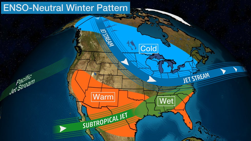
A southward shift in the polar jet stream often emerges during a neutral winter, bringing with it colder-than-average air into portions of the Midwest and Northeast.
Meanwhile, much of the southern tier of the U.S. may end up with a warmer-than-average winter overall.
The subtropical jet stream may also shift the track of storms, resulting in a wet winter in parts of the South. The Pacific storm track may also bring low pressure systems that move more into the Northwest versus California compared to a typical El Niño winter.
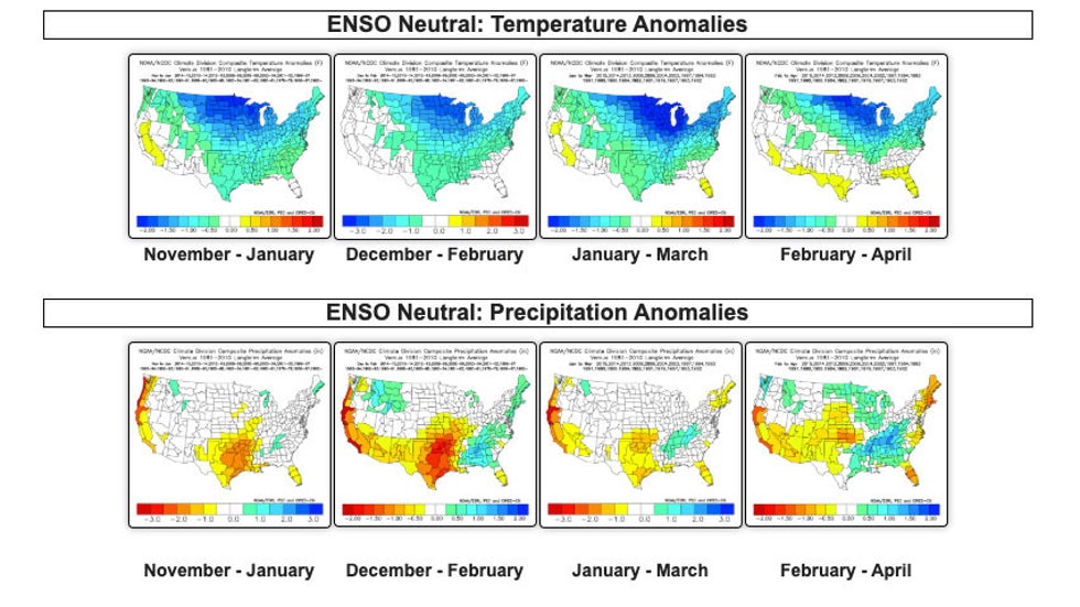
The maps below show the temperature and precipitation departures from average for three month periods during neutral winters since the early 1960s. The 30-year average is based on 1981-2010 data.

There is a strong signal of colder than average temperatures from the Northern Plains into the Great Lakes region from late fall into early spring. Wetter conditions are often experienced in parts of the South during the winter and early spring, while much of California has seen drier conditions during the wet season from November to April.
When looking at just meteorological winter, the December through February period, much of the U.S. has experienced chillier conditions compared to average. Areas form the West Coast into the Southern Plains are often drier, while parts of the Southeast and Northeast and northern Rockies are wetter than average.
It is important to note that this is just an overall trend of the season from December through February as a whole, based only on the influence of the neutral ENSO pattern. Individual cold fronts and low pressure systems will deviate from this at times.
The Weather Company’s primary journalistic mission is to report on breaking weather news, the environment and the importance of science to our lives. This story does not necessarily represent the position of our parent company, IBM.
The Weather Company’s primary journalistic mission is to report on breaking weather news, the environment and the importance of science to our lives. This story does not necessarily represent the position of our parent company, IBM.

No comments:
Post a Comment